Category:Dorfkirche Löwenbruch
Jump to navigation
Jump to search
| Object location | | View all coordinates using: OpenStreetMap |
|---|
church building in Teltow-Fläming district, Brandenburg state, Germany  | |||||
| Upload media | |||||
| Instance of | |||||
|---|---|---|---|---|---|
| Named after | |||||
| Location | Löwenbruch, Ludwigsfelde, Teltow-Fläming District, Brandenburg, Germany | ||||
| Street address |
| ||||
| Heritage designation | |||||
| Inception |
| ||||
| Width |
| ||||
| Length |
| ||||
| Area |
| ||||
| Religion or worldview | |||||
 | |||||
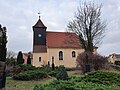
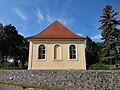
This is the category of the Brandenburger Baudenkmal (cultural heritage monument) with the ID 09105387 (Wikidata)
|
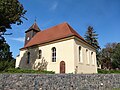
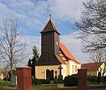
English: Pictures of the church "St. Anna" in Löwenbruch, Ludwigsfelde municipality, Teltow-Fläming district, Brandenburg state, Germany.
Deutsch: Ansichten der Kirche "St. Anna" in Löwenbruch, Stadt Ludwigsfelde , Landkreis Teltow-Fläming , Land Brandenburg , Deutschland.
Français : Photos de l'église "St. Anna" à Löwenbruch, ville de Ludwigsfelde, , arrondissement de Teltow-Fläming , état federé de Brandebourg , Allemagne.
Español: Vistas de la iglesia "St. Anna" en Löwenbruch, ciudad de Ludwigsfelde, distrito de Teltow-Fläming , estado federado de Brandeburgo , Alemania.
Address: Alt-Löwenbruch 22, 14974 Ludwigsfelde - Löwenbruch
Pages in category "Dorfkirche Löwenbruch"
This category contains only the following page.
Media in category "Dorfkirche Löwenbruch"
The following 17 files are in this category, out of 17 total.
-
 Dorfkirche Löwenbruch - Germany - panoramio.jpg 2,592 × 1,944; 2.06 MB
-
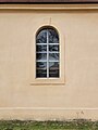 Dorfkirche Löwenbruch 2022 Fenster.jpg 3,014 × 4,024; 3.74 MB
-
 Dorfkirche Löwenbruch 2022 N.jpg 4,032 × 3,024; 2.98 MB
-
 Dorfkirche Löwenbruch 2022 NE.jpg 4,032 × 3,024; 3.69 MB
-
 Dorfkirche Löwenbruch 2022 NNE.jpg 4,032 × 3,024; 3.45 MB
-
 Dorfkirche Löwenbruch 2022 NW.jpg 3,024 × 4,032; 4.26 MB
-
 Dorfkirche Löwenbruch 2022 Panorama NW.jpg 3,712 × 2,304; 4.57 MB
-
 Dorfkirche Löwenbruch 2022 Panorama SW.jpg 4,032 × 3,024; 5.68 MB
-
 Dorfkirche Löwenbruch 2022 S.jpg 4,032 × 3,024; 4.67 MB
-
 Dorfkirche Löwenbruch 2022 SW.jpg 2,932 × 3,964; 6.87 MB
-
 Dorfkirche Löwenbruch 2022 Turm.jpg 2,932 × 3,964; 3.04 MB
-
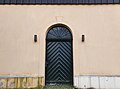 Dorfkirche Löwenbruch 2022 Westportal.jpg 4,002 × 2,982; 3.2 MB
-
 Dorfkirche Löwenbruch Ostansicht.jpg 4,608 × 3,456; 5.92 MB
-
 Dorfkirche Löwenbruch Südostansicht.jpg 4,608 × 3,456; 5.97 MB
-
 Dorfkirche Löwenbruch Westansicht.jpg 3,456 × 4,608; 4.09 MB
-
 Loewenbruch1 Kirche.JPG 626 × 531; 78 KB
-
 Loewenbruch2 Kirche.JPG 649 × 539; 60 KB


