Category:Dorfkirche Kemlitz (Baruth/Mark)
Jump to navigation
Jump to search
| Object location | | View all coordinates using: OpenStreetMap |
|---|
This is the category of the Brandenburger Baudenkmal (cultural heritage monument) with the ID 09105310 (Wikidata)
|
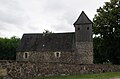
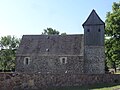
church building in Kemlitz, Germany  | |||||
| Upload media | |||||
| Instance of | |||||
|---|---|---|---|---|---|
| Location | Baruth/Mark, Teltow-Fläming District, Brandenburg, Germany | ||||
| Architectural style | |||||
| Heritage designation | |||||
 | |||||
Media in category "Dorfkirche Kemlitz (Baruth/Mark)"
The following 13 files are in this category, out of 13 total.
-
 Dorfkirche Kemlitz - Germany - panoramio.jpg 2,592 × 1,944; 2.07 MB
-
 Dorfkirche Kemlitz - panoramio.jpg 2,592 × 1,944; 2.59 MB
-
 Dorfkirche Kemlitz Baruth Mark.jpg 4,928 × 3,264; 8.69 MB
-
 Dorfkirche Kemlitz Innenraum.jpg 2,592 × 1,944; 1.69 MB
-
 Dorfkirche Kemlitz Kirchenschiff Südseite westliche Pforte.jpg 2,592 × 1,944; 3.75 MB
-
 Dorfkirche Kemlitz Kirchenschiff Südseite östliche Pforte.jpg 2,592 × 1,944; 3.4 MB
-
 Dorfkirche Kemlitz Kirchenschiff Südseite.jpg 2,592 × 1,944; 3.36 MB
-
 Dorfkirche Kemlitz Nordansicht.jpg 2,592 × 1,944; 2.6 MB
-
 Dorfkirche Kemlitz Ostansicht.jpg 1,944 × 2,592; 2.44 MB
-
 Dorfkirche Kemlitz Südansicht.jpg 2,592 × 1,944; 2.82 MB
-
 Dorfkirche Kemlitz Westansicht.jpg 2,592 × 1,944; 2.35 MB
-
 KemlitzKirkeSkakbrætsten.JPG 644 × 1,028; 88 KB
-
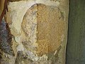 KemlitzKirkeSkakbrætstenNær.JPG 1,280 × 960; 76 KB


