Category:Dorfkirche Grüna
Jump to navigation
Jump to search
| Object location | | View all coordinates using: OpenStreetMap |
|---|
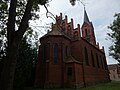
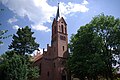
This is the category of the Brandenburger Baudenkmal (cultural heritage monument) with the ID 09105320 (Wikidata)
|
church building in Brandenburg state, Germany  | |||||
| Upload media | |||||
| Instance of | |||||
|---|---|---|---|---|---|
| Location | Grüna, Jüterbog, Teltow-Fläming District, Brandenburg, Germany | ||||
| Heritage designation | |||||
 | |||||
Media in category "Dorfkirche Grüna"
The following 12 files are in this category, out of 12 total.
-
 Dorfkirche Grüna - panoramio.jpg 2,448 × 3,264; 3.15 MB
-
 Dorfkirche Grüna Kirchenschiff Nordansicht.jpg 4,608 × 3,456; 5.55 MB
-
 Dorfkirche Grüna Kirchenschiff Südansicht.jpg 4,608 × 3,456; 6.29 MB
-
 Dorfkirche Grüna Nordostansicht.jpg 4,608 × 3,456; 5.12 MB
-
 Dorfkirche Grüna Nordwestansicht.jpg 3,456 × 4,608; 4.79 MB
-
 Dorfkirche Grüna Ostansicht.jpg 3,456 × 4,608; 5.03 MB
-
 Dorfkirche Grüna Westportal.jpg 4,608 × 3,456; 5.58 MB
-
 Dorfkirche Grüna Westturm Nordostansicht.jpg 3,456 × 4,608; 4.39 MB
-
 Dorfkirche Grüna Westturm Nordwestansicht.jpg 3,456 × 4,608; 3.56 MB
-
 Dorfkirche Grüna Westturm Südansicht.jpg 3,456 × 4,608; 5.1 MB
-
 Dorfkirche in Grüna - panoramio.jpg 3,264 × 2,448; 3.12 MB
-
 Grüna Kirche Jüterbog.jpg 3,872 × 2,592; 1.42 MB


