Category:Dorfkirche (Rauen)
Jump to navigation
Jump to search
| Object location | | View all coordinates using: OpenStreetMap |
|---|
church building in Oder-Spree district, Brandenburg state, Germany  | |||||
| Upload media | |||||
| Instance of | |||||
|---|---|---|---|---|---|
| Location | Rauen, Oder-Spree District, Brandenburg, Germany | ||||
 | |||||
This is the category of the Brandenburger Baudenkmal (cultural heritage monument) with the ID 09115328 (Wikidata)
|
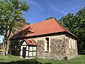
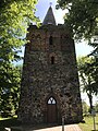
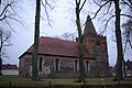
Deutsch: Die Dorfkirche in Rauen, Mark Brandenburg, gehört und dient einer lutherischen Gemeinde der unierten Evangelischen Kirche Berlin-Brandenburg-Schlesische Oberlausitz.
English: The Village Church in Rauen, March of Brandenburg, Germany, is owned and used by a Lutheran parish within the Evangelical Church of Berlin-Brandenburg-Silesian Upper Lusatia, a united Protestant church body of Calvinist, Lutheran and united congregations.
Media in category "Dorfkirche (Rauen)"
The following 24 files are in this category, out of 24 total.
-
 Dorfkirche Rauen 2021-04-04.jpg 1,600 × 900; 600 KB
-
 Dorfkirche Rauen Chor Nordseite Fundamentreste.jpg 4,032 × 3,024; 4.67 MB
-
 Dorfkirche Rauen Chor Nordseite.jpg 3,024 × 4,032; 4.34 MB
-
 Dorfkirche Rauen Kirchenschiff Nordansicht.jpg 4,032 × 3,024; 1.82 MB
-
 Dorfkirche Rauen Kirchenschiff Südansicht.jpg 4,032 × 3,024; 4.58 MB
-
 Dorfkirche Rauen Kirchenschiff Südseite Pforte.jpg 4,032 × 3,024; 4.25 MB
-
 Dorfkirche Rauen Nordostansicht.jpg 4,032 × 3,024; 3.62 MB
-
 Dorfkirche Rauen Ostansicht.jpg 4,032 × 3,024; 5.02 MB
-
 Dorfkirche Rauen Südostansicht.jpg 4,032 × 3,024; 4.35 MB
-
 Dorfkirche Rauen Westportal.jpg 3,024 × 4,032; 3.26 MB
-
 Dorfkirche Rauen Westturm Nordansicht.jpg 3,024 × 4,032; 2.54 MB
-
 Dorfkirche Rauen Westturm Südansicht.jpg 3,024 × 4,032; 4.44 MB
-
 Dorfkirche Rauen Westturm Westansicht.jpg 3,024 × 4,032; 4.27 MB
-
 Feldsteinkirche Rauen.JPG 2,247 × 1,719; 1.32 MB
-
 Rauen - Dorfkirche - panoramio.jpg 640 × 480; 75 KB
-
 Rauen Kirche Nordostseite.JPG 1,600 × 1,200; 945 KB
-
 Rauen Kirche Nordseite.jpg 2,860 × 1,833; 856 KB
-
 Rauen Kirche Ostseite.JPG 1,600 × 1,200; 1.07 MB
-
 Rauen Kirche Südseite.JPG 1,600 × 1,200; 913 KB
-
 Rauen Kirche Westturm.JPG 1,200 × 1,600; 1.05 MB
-
 Rauen Kirche.jpg 3,872 × 2,592; 1.15 MB
-
 Rauen, Brandenburg - Kirche (back) (Zeno Ansichtskarten).jpg 2,148 × 1,360; 89 KB
-
 Rauen, Brandenburg - Kirche (Zeno Ansichtskarten).jpg 2,144 × 1,372; 269 KB
-
 Rauen, die Dorfkirche.jpg 2,551 × 1,701; 1.72 MB


_(Zeno_Ansichtskarten).jpg)
.jpg)
