Category:Donkin Reserve
Jump to navigation
Jump to search
| Object location | | View all coordinates using: OpenStreetMap |
|---|
| This category shows a South African Protected Site with SAHRA file reference 9/2/073/0005. |
Subcategories
This category has the following 2 subcategories, out of 2 total.
T
- The Hill Lighthouse (25 F)
Media in category "Donkin Reserve"
The following 52 files are in this category, out of 52 total.
-
 9 2 073 0005-Donkin Reserve-Port Elizabeth-s.jpg 1,500 × 2,002; 962 KB
-
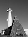
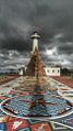
 Donkin Hill Lighthouse and Memorial Pyramid.jpg 3,135 × 2,060; 6.5 MB
-
 Donkin Lighthouse and Pyramid (8712774449).jpg 2,832 × 4,256; 8.21 MB
-
 Donkin Memorial and Lighthouse, Donkin Reserve, Port Elizabeth, South Africa.jpg 1,295 × 1,683; 518 KB
-
 Donkin Memorial-010.jpg 1,200 × 1,200; 136 KB
-
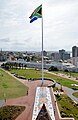 Donkin Reserve Giant Flagpole.jpg 3,150 × 4,852; 8.89 MB
-
 Donkin Reserve memorial.jpg 3,240 × 4,320; 5.16 MB
-
 Donkin Reserve Port Elizabeth-001.jpg 1,756 × 1,200; 789 KB
-
 Donkin Reserve Port Elizabeth-002.jpg 800 × 1,200; 562 KB
-
 Donkin Reserve Port Elizabeth-003.jpg 800 × 1,200; 628 KB
-
 Donkin Reserve Port Elizabeth-004.jpg 1,800 × 1,200; 837 KB
-
 Donkin Reserve Port Elizabeth-005.jpg 1,800 × 1,200; 743 KB
-
 Donkin Reserve Port Elizabeth-006.jpg 800 × 1,200; 566 KB
-
 Donkin Reserve Port Elizabeth-007.jpg 800 × 1,200; 185 KB
-
 Donkin Reserve Port Elizabeth-008.jpg 1,800 × 1,200; 1,020 KB
-
 Donkin Reserve Port Elizabeth-009.jpg 800 × 1,200; 566 KB
-
 Donkin Reserve Port Elizabeth-010.jpg 1,800 × 1,200; 1.07 MB
-
 Donkin Reserve Port Elizabeth-011.jpg 800 × 1,200; 575 KB
-
 Donkin Reserve Port Elizabeth-012.jpg 1,800 × 1,200; 662 KB
-
 Donkin Reserve Port Elizabeth-013.jpg 800 × 1,200; 297 KB
-
 Donkin Reserve Port Elizabeth-014.jpg 1,800 × 1,200; 1.17 MB
-
 Donkin Reserve Port Elizabeth-015.jpg 1,800 × 1,200; 1.3 MB
-
 Donkin Reserve Port Elizabeth-016.jpg 799 × 1,200; 465 KB
-
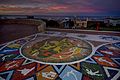
 Donkin Reserve Pyramid and Mosaic.JPG 3,000 × 4,000; 4.32 MB
-
 Donkin Reserve, PE.jpg 1,024 × 849; 315 KB
-
 Donkin Reserve, Port Elizabeth.JPG 3,993 × 2,911; 3.49 MB
-
 Mosaic walkway at the Donkin Reserve Port Elizabeth South Africa.jpg 2,248 × 4,000; 6.3 MB
-
 Palmerston Hotel, Port Elizabeth.jpg 1,000 × 730; 214 KB
-
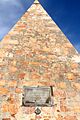
 Plaque on the pyramid at the Donkin Reserve, Port Elizabeth, South Africa.jpg 2,816 × 1,880; 4.24 MB
-
 Port Elizabeth Donkin and Grey institute very early photo.JPG 810 × 553; 431 KB
-
 Port Elizabeth Donkin Lighthouse and pyramid at sunrise.JPG 600 × 800; 293 KB
-
 Port Elizabeth Donkin Lighthouse and pyramid early photo.JPG 890 × 664; 514 KB
-
 Port Elizabeth Donkin Lighthouse and pyramid moonrise.JPG 1,280 × 815; 506 KB
-
 Port Elizabeth Donkin Lighthouse and pyramid with sunrise.JPG 1,280 × 853; 724 KB
-

-
 Port Elizabeth Donkin reserve from the top of the lighthouse.JPG 9,140 × 1,995; 11.4 MB
-
 Port Elizabeth Donkin reserve launch of route 67.JPG 1,280 × 719; 777 KB
-
 Port Elizabeth Donkin reserve pathway lights.JPG 942 × 1,280; 888 KB
-
 Port Elizabeth Donkin reserve the voting line path.JPG 1,280 × 719; 748 KB
-
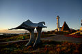
 Port Elizabeth Donkin reserve voting line freedom bird and donkin terrace.JPG 1,280 × 960; 883 KB
-
 Port Elizabeth Donkin reserve voting line.JPG 1,280 × 950; 744 KB
-
 Port Elizabeth Route 67 launch guided walk up voting path.JPG 1,280 × 960; 619 KB
-
 Port Elizabeth Route 67 looking down voting path 2.JPG 1,280 × 873; 618 KB
-
 Port Elizabeth route 67 voting line sunrise.JPG 1,280 × 960; 180 KB
-
 Port Elizabeth steps up to donkin reserve on Route 67.JPG 1,280 × 917; 455 KB
-
 PortElizabeth RouteMarker.jpg 3,456 × 5,184; 4.55 MB
-
 Pyramid on the Donkin Reserve, Port Elizabeth, South Africa.jpg 1,068 × 1,600; 1.59 MB
-
 Route67 1 copy.JPG 4,256 × 2,832; 1.19 MB
-
 Route67 3 copy.JPG 4,256 × 2,832; 1.28 MB
-
 Route67017 copy.JPG 4,256 × 2,832; 990 KB
-
 The Donkin Reserve, Port Elizabeth.jpg 540 × 960; 89 KB
-
 The steps for print.JPG 1,600 × 1,176; 1,018 KB


.jpg)


