Category:Distant views of Shalloch on Minnoch (mountain)
Jump to navigation
Jump to search
Media in category "Distant views of Shalloch on Minnoch (mountain)"
The following 13 files are in this category, out of 13 total.
-
 Across Tunskeen Lane - geograph.org.uk - 904273.jpg 640 × 480; 89 KB
-
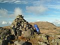
 Cairn on Meikle Millyea - geograph.org.uk - 1115636.jpg 640 × 480; 97 KB
-
 In Carrick Forest - geograph.org.uk - 904269.jpg 450 × 600; 67 KB
-
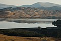 Loch Braden - geograph.org.uk - 696048.jpg 640 × 426; 186 KB
-
 Loch Macaterick View - geograph.org.uk - 904290.jpg 640 × 480; 86 KB
-

-
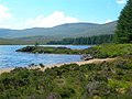
 Macaterick Shore Line - geograph.org.uk - 904303.jpg 640 × 480; 106 KB
-
 Rowantree Hill - geograph.org.uk - 419377.jpg 640 × 480; 104 KB
-
 Sheil Rig Burn enters the forest. - geograph.org.uk - 951169.jpg 640 × 480; 101 KB
-
 Tarfessock summit - geograph.org.uk - 1084148.jpg 640 × 480; 94 KB
-
 Tarfessock Summit. - geograph.org.uk - 27488.jpg 640 × 354; 41 KB
-
 Towards Shalloch On Minnoch - geograph.org.uk - 997073.jpg 640 × 369; 80 KB
-
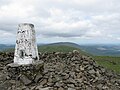 Trig Point on the Merrick - geograph.org.uk - 1392917.jpg 640 × 480; 72 KB


