Category:Dhone
Jump to navigation
Jump to search
| Object location | | View all coordinates using: OpenStreetMap |
|---|
town in Dhone mandal, Nandyal district, Andhra Pradesh, India  | |||||
| Upload media | |||||
| Instance of |
| ||||
|---|---|---|---|---|---|
| Location | Dhone mandal, Nandyal district, Andhra Pradesh, India | ||||
| Population |
| ||||
| Area |
| ||||
| Elevation above sea level |
| ||||
 | |||||
Media in category "Dhone"
The following 13 files are in this category, out of 13 total.
-
 17660 WDM-2 loco at (Dronachalam) Dhone Junction.jpg 3,072 × 2,304; 3.13 MB
-
 A lake near Dhone 01.jpg 640 × 445; 123 KB
-
 A lake near Dhone 02.jpg 619 × 390; 171 KB
-
 A Temple near Dhone 01.jpg 572 × 420; 226 KB
-
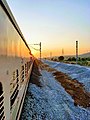 A train near Dhone Dronachalam.jpg 3,000 × 4,000; 3.37 MB
-
 A view near Dhone town 01.jpg 640 × 420; 147 KB
-
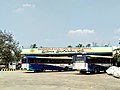 Dhone Bus Stand 1A.jpg 4,000 × 3,000; 1.95 MB
-
 Dhone Jn Railway station image.jpg 3,264 × 1,836; 2.03 MB
-
 Dhone Railway Station 1A.jpg 4,608 × 3,456; 5.78 MB
-
 Dhone Railway Station 1B.jpg 2,304 × 1,537; 1.73 MB
-
 DHONE STATION BOARD.jpg 1,200 × 900; 128 KB
-
 Hills near Dhone 01.jpg 640 × 480; 157 KB
-
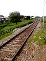 Train route to Nandyal at Dhone.jpg 480 × 640; 237 KB
_Dhone_Junction.jpg)


