Category:Den Alerdinck, Laag Zuthem
Jump to navigation
Jump to search
| Object location | | View all coordinates using: OpenStreetMap |
|---|
building in the Netherlands  | |||||
| Upload media | |||||
| Instance of | |||||
|---|---|---|---|---|---|
| Part of | |||||
| Location | Laag Zuthem, Raalte, Overijssel, Netherlands | ||||
| Street address |
| ||||
| Located on street |
| ||||
| Heritage designation |
| ||||
 | |||||
| Address |
|
| |||
| Hoofdgebouw: |
| ||
| Historische aanleg: |
| ||
| Bouwhuis: |
| ||
| Toegangshek: |
| ||
| Toegangshek: |
| ||
| Oranjerie: |
| ||
| Tuinmuur: |
| ||
| Siervazen: |
|
Nederlands: Havezate den Alerdinck te Laag Zuthem
Media in category "Den Alerdinck, Laag Zuthem"
The following 10 files are in this category, out of 10 total.
-
 Aledinck hek.jpg 2,040 × 1,476; 521 KB
-
 Alerdinck oranjerie.jpg 2,034 × 1,464; 417 KB
-
 Alerdinck siervaas..jpg 2,040 × 1,476; 426 KB
-
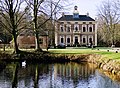 Alerdinck.jpg 2,012 × 1,473; 736 KB
-
 Exterieur OVERZICHT VOORGEVEL - Heino - 20311273 - RCE.jpg 1,200 × 944; 277 KB
-
 Exterieur VOORGEVEL, LINKER ZIJGEVEL - Heino - 20311272 - RCE.jpg 1,200 × 947; 347 KB
-

-
 Overzicht - Heino - 20107110 - RCE.jpg 1,200 × 806; 239 KB
-
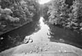 Vijver achter 't huis - Heino - 20107113 - RCE.jpg 1,200 × 820; 259 KB
-
 Voorgevel - Heino - 20107111 - RCE.jpg 1,200 × 816; 257 KB


_en_reg,_Bestanddeelnr_927-8049.jpg)


