Category:Demographic maps of Africa
Jump to navigation
Jump to search
Temperate regions: North America · South America · Africa · Europe · Asia · Oceania – Polar regions: – Other regions:
Countries of Africa: Algeria · Angola · Benin · Botswana · Burkina Faso · Burundi · Cameroon · Cape Verde · the Central African Republic ≈ Central African Republic · Chad · the Comoros ≈ Comoros · the Democratic Republic of the Congo ≈ Democratic Republic of the Congo · the Republic of the Congo ≈ Republic of the Congo · Djibouti · Egypt‡ · Equatorial Guinea · Eritrea · Eswatini · Ethiopia · Gabon · the Gambia ≈ Gambia · Ghana · Guinea · Guinea-Bissau · Ivory Coast · Kenya · Lesotho · Liberia · Libya · Madagascar · Malawi · Mali · Mauritania · Mauritius · Morocco · Mozambique · Namibia · Niger · Nigeria · Rwanda · São Tomé and Príncipe · Senegal · the Seychelles ≈ Seychelles · Sierra Leone · Somalia · South Africa · South Sudan · Sudan · Tanzania · Togo · Tunisia · Uganda · Zambia · Zimbabwe
Limited recognition: Ambazonia · Azawad · Puntland · the Sahrawi Arab Democratic Republic ≈ Sahrawi Arab Democratic Republic · Somaliland – Other areas: Bir Tawil · the Canary Islands ≈ Canary Islands · Ceuta · Madeira · Mayotte · Melilla · Réunion · Saint Helena, Ascension and Tristan da Cunha · the Scattered Islands in the Indian Ocean ≈ Scattered Islands in the Indian Ocean · Western Sahara
‡: partly located in Africa
| NO WIKIDATA ID FOUND! Search for Demographic maps of Africa on Wikidata | |
| Upload media |
Subcategories
This category has the following 41 subcategories, out of 41 total.
- HDI maps of Africa (17 F)
*
A
B
C
D
E
- Demographic maps of Egypt (3 F)
G
I
K
L
M
N
S
- Demographic maps of Somalia (7 F)
T
U
- Urban area maps of Africa (109 F)
Z
Media in category "Demographic maps of Africa"
The following 11 files are in this category, out of 11 total.
-
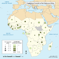
 Adolescent Fertility and Poverty in Africa.jpg 612 × 792; 104 KB
-
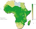
 African countries by population, 2018.png 4,245 × 4,602; 628 KB
-
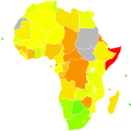
 Fertility Rates and Life Expectancy in Sub-Saharan Africa.png 2,243 × 2,248; 539 KB
-
 Fuzzy1.jpg 637 × 625; 57 KB
-
 Ibrahim-index-of-african-governance-economic.svg 1,000 × 1,000; 187 KB
-
 Ibrahim-index-of-african-governance-human-development.svg 1,000 × 1,000; 187 KB
-
 Ibrahim-index-of-african-governance-human-rights.svg 1,000 × 1,000; 187 KB
-
 Ibrahim-index-of-african-governance-rule-of-law.svg 1,000 × 1,000; 197 KB
-
 Ibrahim-index-of-african-governance.svg 1,000 × 1,000; 159 KB
-
 New africa map pop-under-15y.jpg 1,027 × 830; 173 KB
-
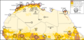 Sahara - Demografia.png 1,470 × 707; 369 KB


