Category:Deeping Gate
Jump to navigation
Jump to search
English: Deeping Gate is a village and civil parish, lying on the River Welland in Cambridgeshire. Traditionally, the area was part of the Soke of Peterborough, geographically considered a part of Northamptonshire; it now falls within the City of Peterborough unitary authority area. With a very small population, void of any major services, including a post office or even a chapel, the community depends on nearby Market Deeping, one and a quarter miles (2 km) north of the river in Lincolnshire, for economic and market services. Renaissance composer Robert Fayrfax was a native of the village.
village and civil parish in Cambridgeshire, England, UK  | |||||
| Upload media | |||||
| Instance of | |||||
|---|---|---|---|---|---|
| Location | City of Peterborough, Cambridgeshire, East of England, England | ||||
 | |||||
Media in category "Deeping Gate"
The following 119 files are in this category, out of 119 total.
-
 2016, a year on Geograph (Day 177) - geograph.org.uk - 5012188.jpg 640 × 480; 75 KB
-
 A15 roadbridge - geograph.org.uk - 5023195.jpg 640 × 480; 104 KB
-
 Along the River Welland - geograph.org.uk - 5023174.jpg 640 × 480; 89 KB
-
 Along the River Welland - geograph.org.uk - 5023179.jpg 640 × 480; 62 KB
-
 Along the River Welland - geograph.org.uk - 5023180.jpg 640 × 480; 57 KB
-
 Along the River Welland - geograph.org.uk - 5023190.jpg 640 × 480; 100 KB
-
 Along the River Welland - geograph.org.uk - 5023192.jpg 640 × 480; 56 KB
-
 Alongside Maxey House - geograph.org.uk - 5023183.jpg 640 × 480; 50 KB
-
 Alongside the Lincoln Road - geograph.org.uk - 5023187.jpg 640 × 480; 58 KB
-
 Bridge over River Welland - geograph.org.uk - 4614729.jpg 6,081 × 4,053; 4.65 MB
-
 Bridge over the River Welland, Market Deeping - geograph.org.uk - 3203576.jpg 1,024 × 607; 219 KB
-
 Bridgegate Lane (track) - geograph.org.uk - 5368032.jpg 640 × 480; 72 KB
-
 Bridgegate Lane (track) - geograph.org.uk - 5368036.jpg 640 × 480; 69 KB
-
 Cottages alongside the River Welland, Deeping Gate - geograph.org.uk - 5049281.jpg 4,608 × 3,456; 6.14 MB
-
 Cottages alongside the River Welland, Deeping Gate - geograph.org.uk - 5049341.jpg 3,456 × 4,608; 6.12 MB
-
 Deeping Gate - geograph.org.uk - 5072087.jpg 640 × 480; 61 KB
-
 Deeping Gate bridge - geograph.org.uk - 4664451.jpg 1,280 × 960; 380 KB
-
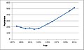 Deeping Gate population time series 1881-2011.jpg 481 × 289; 23 KB
-
 Deeping High Locks on the River Welland, Deeping St. James - geograph.org.uk - 5049360.jpg 4,608 × 3,456; 6.15 MB
-
 Deeping St James bridge - geograph.org.uk - 2366302.jpg 2,592 × 1,944; 1.25 MB
-
 Deeping St James Road, Northborough - geograph.org.uk - 3118837.jpg 640 × 480; 66 KB
-
 Disused barn off Lincoln Road, Deeping Gate - geograph.org.uk - 4974346.jpg 4,000 × 3,000; 5.05 MB
-
 Drain off Deeping St James Road - geograph.org.uk - 3118838.jpg 640 × 480; 122 KB
-
 Entering Market Deeping - geograph.org.uk - 3510573.jpg 1,024 × 768; 289 KB
-
 Fairfax Way - geograph.org.uk - 5367929.jpg 640 × 480; 61 KB
-
 Fairfax Way - geograph.org.uk - 6399709.jpg 480 × 640; 44 KB
-
 Farm buildings alongside the River Welland, Market Deeping - geograph.org.uk - 3716024.jpg 4,000 × 3,000; 2.58 MB
-
 Field Drain - geograph.org.uk - 5579222.jpg 640 × 480; 100 KB
-
 Footbridge over The River Welland, Deeping Gate - geograph.org.uk - 3827626.jpg 4,320 × 3,240; 6.02 MB
-
 Ford at Market Deeping - geograph.org.uk - 2126681.jpg 3,872 × 2,592; 2.37 MB
-
 Former road to Maxey - geograph.org.uk - 864864.jpg 640 × 480; 121 KB
-
 Frozen river Welland - geograph.org.uk - 2401567.jpg 1,600 × 1,200; 287 KB
-
 Frozen river Welland - geograph.org.uk - 2401587.jpg 1,600 × 1,200; 453 KB
-
 Gate across Lincoln Road, Northborough - geograph.org.uk - 5921114.jpg 1,632 × 920; 577 KB
-
 Gate across Lincoln Road, Northborough - geograph.org.uk - 6036169.jpg 1,632 × 920; 258 KB
-
 High hedge north of Rippons Drove - geograph.org.uk - 3793751.jpg 4,320 × 3,240; 5.58 MB
-
 High locks Deeping St James - geograph.org.uk - 1811128.jpg 2,560 × 1,920; 1.39 MB
-
 High Locks Deeping St James geograph 705171.jpg 640 × 427; 67 KB
-
 High Locks on River Welland, Deeping Gate - geograph.org.uk - 640980.jpg 634 × 467; 133 KB
-
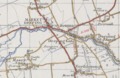 Historical map showing Deeping Gate.PNG 581 × 380; 455 KB
-
 House by the River Welland - geograph.org.uk - 3118828.jpg 640 × 480; 98 KB
-
 Houses alongside the River Welland at Market Deeping - geograph.org.uk - 3629311.jpg 4,000 × 3,000; 2.65 MB
-
 Houses alongside the River Welland at Market Deeping - geograph.org.uk - 3629340.jpg 4,000 × 3,000; 2.96 MB
-
 Houses alongside the River Welland, Deeping Gate - geograph.org.uk - 3971387.jpg 4,000 × 3,000; 2.63 MB
-
 Houses alongside the River Welland, Deeping Gate - geograph.org.uk - 3971399.jpg 4,000 × 3,000; 2.64 MB
-
 Housing and farmland, Northborough - geograph.org.uk - 4178561.jpg 4,320 × 3,240; 5.38 MB
-
 How to build a skew bridge - geograph.org.uk - 4614741.jpg 6,071 × 4,047; 3.86 MB
-
 Maxey House, Deeping Gate - geograph.org.uk - 3660471.jpg 4,000 × 3,000; 2.37 MB
-
 Maxey House, Deeping Gate - geograph.org.uk - 4057365.jpg 4,000 × 3,000; 2.93 MB
-
 Maxey House, Deeping Gate - geograph.org.uk - 4462374.jpg 4,000 × 3,000; 2.92 MB
-
 Maxey House, Deeping Gate - geograph.org.uk - 4462377.jpg 4,000 × 3,000; 2.62 MB
-
 New house, Northborough - geograph.org.uk - 3118834.jpg 640 × 480; 85 KB
-
 Old stone bridge at Deeping Gate - geograph.org.uk - 1811097.jpg 2,560 × 1,920; 1.41 MB
-
 Pack horse bridge over the River Welland, Deeping St. James - geograph.org.uk - 3971499.jpg 4,000 × 3,000; 2.68 MB
-
 Packhorse Bridge, Deeping St James - geograph.org.uk - 3109359.jpg 640 × 426; 90 KB
-
 Parish boundary sign, Northborough - geograph.org.uk - 4418401.jpg 3,000 × 4,000; 2.93 MB
-
 Peakirk Road - geograph.org.uk - 6399708.jpg 480 × 640; 50 KB
-

-
 Race at the High Locks - geograph.org.uk - 693504.jpg 427 × 640; 103 KB
-
 River Welland - geograph.org.uk - 2364129.jpg 2,592 × 1,944; 1.27 MB
-
 River Welland - geograph.org.uk - 4615414.jpg 5,500 × 3,667; 5.03 MB
-
 River Welland - geograph.org.uk - 6399702.jpg 480 × 640; 79 KB
-
 River Welland at Deeping Gate - geograph.org.uk - 4664463.jpg 1,280 × 960; 392 KB
-
 River Welland at Deeping Gate - geograph.org.uk - 5049292.jpg 4,608 × 3,456; 4.21 MB
-
 River Welland at Deeping Gate - geograph.org.uk - 5049298.jpg 3,456 × 4,608; 6.22 MB
-
 River Welland at Deeping St. James - geograph.org.uk - 3971203.jpg 4,000 × 3,000; 2.93 MB
-
 River Welland at Deeping St. James - geograph.org.uk - 5049316.jpg 4,608 × 3,456; 5.65 MB
-
 River Welland at Deeping St. James - geograph.org.uk - 5049326.jpg 4,608 × 3,456; 5.9 MB
-
 River Welland at Market Deeping - geograph.org.uk - 4057335.jpg 4,000 × 3,000; 2.55 MB
-
 River Welland at Market Deeping - geograph.org.uk - 4057338.jpg 4,000 × 3,000; 2.62 MB
-
 River Welland Deeping St James - geograph.org.uk - 2361918.jpg 2,592 × 1,944; 1.33 MB
-
 River Welland Deeping St James - geograph.org.uk - 2366558.jpg 2,592 × 1,944; 1.29 MB
-
 River Welland Deeping St James - geograph.org.uk - 2372363.jpg 2,592 × 1,944; 1.3 MB
-
 River Welland looking east, Market Deeping - geograph.org.uk - 3203608.jpg 1,024 × 669; 316 KB
-
 River Welland looking west, Market Deeping - geograph.org.uk - 3203596.jpg 1,024 × 683; 199 KB
-
 River Welland viewed from Market Deeping Bridge - geograph.org.uk - 4462389.jpg 4,000 × 3,000; 2.57 MB
-
 River Welland viewed from Welland Walk, Market Deeping - geograph.org.uk - 5094515.jpg 4,000 × 3,000; 5.03 MB
-
 River Welland viewed from Welland Walk, Market Deeping - geograph.org.uk - 5094538.jpg 4,000 × 3,000; 3.49 MB
-
 River Welland viewed from Welland Walk, Market Deeping - geograph.org.uk - 5094542.jpg 4,000 × 3,000; 5.21 MB
-
 River Welland, Deeping St James - geograph.org.uk - 3101968.jpg 640 × 426; 77 KB
-
 River Welland, Deeping St James - geograph.org.uk - 3101991.jpg 640 × 426; 92 KB
-
 River Welland, Deeping St James - geograph.org.uk - 3102174.jpg 640 × 426; 86 KB
-
 River Welland, Deeping St James - geograph.org.uk - 3102297.jpg 640 × 426; 87 KB
-
 River Welland, Deeping St James - geograph.org.uk - 3105880.jpg 640 × 426; 76 KB
-
 River Welland, Deeping St James - geograph.org.uk - 3105892.jpg 640 × 426; 80 KB
-
 River Welland, Deeping St James - geograph.org.uk - 3107013.jpg 640 × 426; 90 KB
-
 River Welland, Deeping St James - geograph.org.uk - 3108200.jpg 640 × 426; 88 KB
-
 River Welland, Deeping St James - geograph.org.uk - 3109171.jpg 640 × 426; 88 KB
-
 River Welland, Deeping St James - geograph.org.uk - 3109189.jpg 640 × 426; 90 KB
-
 River Welland, Deeping St James - geograph.org.uk - 3118812.jpg 640 × 480; 92 KB
-
 River Welland, swans - geograph.org.uk - 5367923.jpg 640 × 480; 55 KB
-
 River welland.jpg 9,248 × 6,936; 14.19 MB
-
 Riverside - geograph.org.uk - 5367927.jpg 640 × 480; 94 KB
-
 Rural track, Deeping Gate - geograph.org.uk - 864853.jpg 640 × 480; 83 KB
-
 Sutton's Lane, Deeping Gate - geograph.org.uk - 442564.jpg 640 × 427; 104 KB
-
 Sutton's Lane, Deeping Gate - geograph.org.uk - 442575.jpg 640 × 427; 120 KB
-
 The Bell, Deeping St. James - geograph.org.uk - 3971417.jpg 4,000 × 3,000; 2.7 MB
-
 The Bell, Deeping St. James - geograph.org.uk - 3971427.jpg 4,000 × 3,000; 2.87 MB
-
 The Bell, Deeping St. James - geograph.org.uk - 3971445.jpg 4,000 × 3,000; 2.97 MB
-
 The Bell, Deeping St. James - geograph.org.uk - 3971464.jpg 4,000 × 3,000; 2.47 MB
-
 The bridge at Market Deeping, near Bourne, Lincolnshire - geograph.org.uk - 4437621.jpg 2,848 × 2,134; 1.76 MB
-
 The former Black Bull public house, Deeping Gate - geograph.org.uk - 3971679.jpg 4,000 × 3,000; 2.63 MB
-
 The former Black Bull public house, Deeping Gate - geograph.org.uk - 3971693.jpg 4,000 × 3,000; 2.64 MB
-

-

-
 The Old Coach House - geograph.org.uk - 5579233.jpg 640 × 480; 103 KB
-
 The Old Coach House, Market Deeping (with duck) - geograph.org.uk - 4462404.jpg 3,000 × 4,000; 2.64 MB
-
 The Old Coach House, Market Deeping - geograph.org.uk - 4057324.jpg 4,000 × 3,000; 2.59 MB
-
 The Pack Horse Bridge in Deeping St James - geograph.org.uk - 3793785.jpg 4,320 × 3,240; 5.77 MB
-
 The River Welland - geograph.org.uk - 3118818.jpg 640 × 480; 117 KB
-
 The River Welland at the old lock, Deeping Gate - geograph.org.uk - 3827618.jpg 4,320 × 3,240; 5.53 MB
-
 Towards Lincoln Road - geograph.org.uk - 5023184.jpg 640 × 480; 55 KB
-
 Towards Market Deeping Bridge - geograph.org.uk - 5023197.jpg 640 × 480; 67 KB
-
 Towards the A15 - geograph.org.uk - 5023194.jpg 640 × 480; 98 KB
-
 Town Bridge, Market Deeping - geograph.org.uk - 6218831.jpg 1,632 × 920; 365 KB
-
 Wade Park Avenue - geograph.org.uk - 961447.jpg 640 × 428; 74 KB
-
 Weirs and footbridge - geograph.org.uk - 6399698.jpg 480 × 640; 102 KB
-
 Welcome to Peterborough - geograph.org.uk - 4974419.jpg 3,000 × 4,000; 5.32 MB
-
 Willow on the bank of the River Welland - geograph.org.uk - 3827586.jpg 4,320 × 3,240; 5.79 MB
_-_geograph.org.uk_-_5012188.jpg)


_-_geograph.org.uk_-_5368032.jpg)
_-_geograph.org.uk_-_5368036.jpg)


,_Bridge_Foot,_Market_Deeping_-_geograph.org.uk_-_3204786.jpg)

_-_geograph.org.uk_-_4462404.jpg)


