Category:De Tempel estate
Jump to navigation
Jump to search
| Object location | | View all coordinates using: OpenStreetMap |
|---|
 | |||||
| Upload media | |||||
| Instance of | |||||
|---|---|---|---|---|---|
| Location | Rotterdam, South Holland, Netherlands | ||||
| Street address |
| ||||
| Has part(s) | |||||
| Heritage designation |
| ||||
 | |||||
| Address |
|
Subcategories
This category has the following 2 subcategories, out of 2 total.
N
- Nature at De Tempel estate (11 F)
S
- Sculptures at De Tempel estate (11 F)
Media in category "De Tempel estate"
The following 31 files are in this category, out of 31 total.
-
 "De Tempel", park en huis - Overschie - 20181287 - RCE.jpg 1,200 × 812; 346 KB
-
 Achtergevel en linkerzijgevel - Overschie - 20326728 - RCE.jpg 687 × 1,200; 190 KB
-
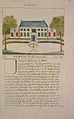 Atlas Schoemaker-ZUIDHOLLAND-DEEL5-2373-Zuid-Holland, Tempel.jpeg 1,023 × 1,648; 338 KB
-
 Badhuis - Overschie - 20327135 - RCE.jpg 1,200 × 857; 229 KB
-
 Bouwhuis - Overschie - 20181289 - RCE.jpg 1,200 × 809; 296 KB
-
 Buitenplaats de Tempel Rotterdam Natuurmonumenten.jpg 6,240 × 4,160; 6.35 MB
-
 Dolfijn - Overschie - 20181296 - RCE.jpg 1,200 × 810; 334 KB
-
 Gezicht vanaf de Delftweg links - Overschie - 20327134 - RCE.jpg 1,200 × 864; 281 KB
-

-
 Interieur schoorsteenmantel zaal - Overschie - 20327131 - RCE.jpg 860 × 1,200; 162 KB
-
 Interieur schoorsteenmantel zaal - Overschie - 20327132 - RCE.jpg 861 × 1,200; 147 KB
-
 Interieur trap - Overschie - 20327102 - RCE.jpg 853 × 1,200; 113 KB
-

-
 Midden van park - Overschie - 20181291 - RCE.jpg 1,200 × 808; 324 KB
-
 Overzicht voorgevel landhuis met gedeelte van park - Overschie - 20377864 - RCE.jpg 1,200 × 1,200; 439 KB
-

-

-

-

-
 Rotterdam delftweg186 bollen.jpg 2,200 × 937; 373 KB
-
 Rotterdam delftweg186 koetshuis.jpg 2,207 × 1,800; 738 KB
-
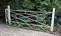 Rotterdam delftweg186 moestuinhekhek.jpg 2,400 × 1,417; 513 KB
-
 Rotterdam delftweg186 rustieke brug.jpg 2,400 × 1,325; 439 KB
-
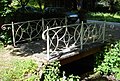 Rotterdam delftweg186 smeedijzeren brug.jpg 2,200 × 1,491; 549 KB
-
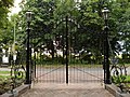 Rotterdam delftweg186 toegangshek.jpg 2,400 × 1,800; 801 KB
-
 Rotterdam delftweg186 tuinhuisje.jpg 1,341 × 1,800; 405 KB
-
 Rotterdam delftweg186 tuinmanswoning.jpg 2,200 × 1,650; 672 KB
-
 Rotterdam delftweg186 voetstuk.jpg 1,495 × 1,567; 447 KB
-
 Theekoepel - Overschie - 20181290 - RCE.jpg 1,200 × 811; 390 KB
-
 Toegangshek - Overschie - 20181288 - RCE.jpg 1,200 × 810; 345 KB
-
 Vooraanzicht vanaf de Delftweg - Overschie - 20327133 - RCE.jpg 1,200 × 862; 281 KB


