Category:De Hoop (Rozenburg)
Jump to navigation
Jump to search
| Object location | | View all coordinates using: OpenStreetMap |
|---|
windmill in Rozenburg, Netherlands  | |||||
| Upload media | |||||
| Instance of | |||||
|---|---|---|---|---|---|
| Part of | |||||
| Location | Rozenburg, South Holland, Netherlands | ||||
| Street address |
| ||||
| Located on street |
| ||||
| Has use | |||||
| Heritage designation |
| ||||
| Source of energy | |||||
 | |||||
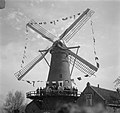
Nederlands: Molen de Hoop aan de Molenweg 30 in Rozenburg (Rotterdam).
|
This is a category about rijksmonument number 364793
|
| Address |
|
Media in category "De Hoop (Rozenburg)"
The following 7 files are in this category, out of 7 total.
-
-
 Ronde stenen molen, bebouwing op de voorgrond - Rotterdam - 20400802 - RCE.jpg 1,200 × 1,174; 212 KB
-
 Rozenburg - molen De Hoop bij nacht.jpg 1,351 × 1,800; 1.12 MB
-
 Rozenburg - molen De Hoop.jpg 1,000 × 1,500; 809 KB
-
 Rozenburg molen.jpg 2,248 × 4,000; 1.58 MB
-
 Rozenburg, molen 2009-08-23 14.10.JPG 1,944 × 2,592; 3.04 MB
-
 Wieken en romp van ronde stenen molen - Rotterdam - 20400801 - RCE.jpg 1,200 × 1,181; 205 KB


