Category:Dąb Bartek
Jump to navigation
Jump to search
| Object location | | View all coordinates using: OpenStreetMap |
|---|
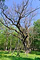
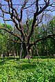
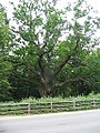
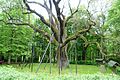
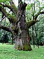
ancient oak tree in Poland  | |||||
| Upload media | |||||
| Instance of | |||||
|---|---|---|---|---|---|
| Location | Zagnańsk, Gmina Zagnańsk, Kielce County, Świętokrzyskie Voivodeship, Poland | ||||
| Heritage designation | |||||
 | |||||
Media in category "Dąb Bartek"
The following 30 files are in this category, out of 30 total.
-
 20180430 Dąb Bartek w Zagnańsku 2550 DxO.jpg 3,717 × 5,590; 31.86 MB
-
 20180430 Dąb Bartek w Zagnańsku 2551 DxO.jpg 4,000 × 6,016; 35.17 MB
-
 20180430 Dąb Bartek w Zagnańsku 2562 DxO.jpg 4,000 × 6,016; 35.93 MB
-
 Bartek 010.jpg 1,200 × 1,600; 634 KB
-
 Bartek 011.jpg 1,600 × 1,200; 572 KB
-
 Bartek-ulica.jpg 768 × 1,024; 617 KB
-
 Dab bartek (1).jpg 3,648 × 2,432; 2.23 MB
-
 Dab bartek (2).jpg 3,648 × 2,432; 2.23 MB
-
 Dab Bartek.jpg 1,024 × 768; 694 KB
-
 Dab bartek.JPG 533 × 600; 104 KB
-
 Dab bartek.jpg 2,432 × 3,648; 2.3 MB
-
 Dab bartek2.JPG 1,152 × 864; 296 KB
-
 Dąb Bartek - Tablica informacyjna.jpg 4,320 × 2,880; 3.98 MB
-
 Dąb Bartek 1.jpg 4,320 × 2,880; 3.85 MB
-
 Dąb Bartek 2.jpg 2,880 × 4,320; 4.09 MB
-
 Dąb Bartek 3.jpg 2,880 × 4,320; 3.97 MB
-
 Dąb Bartek i sygnalizacja świetlna - panoramio.jpg 1,200 × 798; 689 KB
-
 DĄB BARTEK w Bartkowie zdjęcie z 26.VII.1955r.jpg 650 × 950; 187 KB
-
 Dąb Bartek Wojciech Gerson 1873.jpg 1,500 × 1,929; 811 KB
-
 Dąb Bartek.JPG 2,304 × 3,072; 2.75 MB
-
 S6301123.JPG 2,816 × 2,112; 2.59 MB
-
 Zagnańsk. Dąb Bartek 1.jpg 1,187 × 878; 511 KB
-
 Zagnańsk. Dąb Bartek 2.jpg 581 × 821; 240 KB
-
 Zagnańsk. Dąb Bartek 3.jpg 1,130 × 806; 393 KB
-
 Zagnańsk. Dąb Bartek 4.jpg 900 × 1,200; 513 KB
-
 Zagnańsk. Dąb Bartek 5.jpg 857 × 1,168; 538 KB
-
 Zagnańsk. Dąb Bartek 6.jpg 866 × 1,174; 430 KB
-
 Zagnańsk. Dąb Bartek 7.jpg 1,200 × 900; 547 KB
-
 Zagnańsk. Dąb Bartek 8.jpg 900 × 1,192; 572 KB
-
 Zagnańsk. Dąb Bartek. Kapliczka przy dębie.jpg 1,185 × 869; 427 KB


.jpg)
.jpg)


