Category:Crosby Town Hall
Jump to navigation
Jump to search
| Object location | | View all coordinates using: OpenStreetMap |
|---|
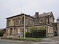
town hall in Waterloo, Merseyside, England, UK  | |||||
| Upload media | |||||
| Instance of | |||||
|---|---|---|---|---|---|
| Location | Waterloo, Sefton, Merseyside, North West England, England | ||||
| Heritage designation |
| ||||
 | |||||
Media in category "Crosby Town Hall"
The following 4 files are in this category, out of 4 total.
-
 Crosby Town Hall 1.jpg 4,944 × 3,338; 23.6 MB
-
 Crosby Town Hall 2.jpg 4,870 × 2,906; 19.48 MB
-
 Crosby Town Hall, Waterloo, Merseyside.jpg 4,320 × 3,240; 3.17 MB
-
 Waterloo Town Hall.jpg 578 × 431; 207 KB


