Category:Creu del Rosselló
Jump to navigation
Jump to search
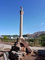
Català: Creu del Rosselló (Súria)
This is a category about a building listed in the Catalan heritage register as Bé Cultural d'Interès Local (BCIL) under the reference IPA-30726. |
| Object location | | View all coordinates using: OpenStreetMap |
|---|
 | |||||
| Upload media | |||||
| Instance of | |||||
|---|---|---|---|---|---|
| Location | Súria, Bages, Barcelona Province, Catalonia | ||||
| Street address |
| ||||
| Heritage designation |
| ||||
| Inception |
| ||||
| Elevation above sea level |
| ||||
 | |||||
Media in category "Creu del Rosselló"
The following 4 files are in this category, out of 4 total.
-
 CREU DEL ROSSELLÓ - SÚRIA - IB-894.jpg 1,536 × 2,048; 956 KB
-
 CREU DEL ROSSELLÓ - SÚRIA - IB-895.jpg 1,536 × 2,048; 965 KB
-
 CREU DEL ROSSELLÓ - SÚRIA - IB-897.jpg 1,536 × 2,048; 940 KB
-
 CREU DEL ROSSELLÓ - SÚRIA - IB-898.jpg 1,536 × 2,048; 953 KB


