Category:Covehithe
Jump to navigation
Jump to search
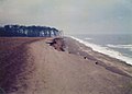
English: Covehithe is a village in Suffolk, England. Lying on the coast around North of Southwold,also a few miles South from the town of Lowestoft it is located within the Suffolk Coast and Heaths AONB.
village in Suffolk, England, UK | |||||
| Upload media | |||||
| Instance of | |||||
|---|---|---|---|---|---|
| Location |
| ||||
 | |||||
Subcategories
This category has the following 3 subcategories, out of 3 total.
Media in category "Covehithe"
The following 200 files are in this category, out of 326 total.
(previous page) (next page)-
 1GL Bolt Covehithe St Andrew's Church - geograph.org.uk - 5390890.jpg 2,231 × 2,231; 3.79 MB
-
 5 barred gate from the beach - geograph.org.uk - 2131551.jpg 640 × 480; 179 KB
-
 A balancing act, Benacre - geograph.org.uk - 2137544.jpg 564 × 640; 165 KB
-

-
 A disappearing track, Covehithe - geograph.org.uk - 2137382.jpg 527 × 640; 112 KB
-
 A disappearing track, Covehithe - geograph.org.uk - 2137389.jpg 589 × 600; 127 KB
-
 A giant tortoise or log Ness monster - geograph.org.uk - 2142056.jpg 640 × 480; 183 KB
-
 A pig meet in the street - geograph.org.uk - 2142039.jpg 640 × 476; 113 KB
-
 A stubble field in Covehithe - geograph.org.uk - 2077413.jpg 640 × 480; 127 KB
-

-
-
 Ancient clay beds, Covehithe Cliffs - geograph.org.uk - 2137307.jpg 640 × 464; 102 KB
-
 Ancient clay, Covehithe Cliffs - geograph.org.uk - 2137503.jpg 640 × 480; 129 KB
-

-
 Ancient Ripples - geograph.org.uk - 2304991.jpg 800 × 531; 155 KB
-
 Approaching Long Covert, Benacre - geograph.org.uk - 2137522.jpg 640 × 472; 118 KB
-
 Arable Land, Covehithe - geograph.org.uk - 5812723.jpg 3,648 × 2,255; 4.69 MB
-
 Autumn colours in Easton Wood - geograph.org.uk - 2143626.jpg 640 × 480; 202 KB
-

-
 Barns across the stubble field - geograph.org.uk - 2077073.jpg 640 × 480; 76 KB
-
 Baventian Clay Beds - geograph.org.uk - 1776748.jpg 800 × 531; 81 KB
-
 Baventian Clay Beds - geograph.org.uk - 2305017.jpg 800 × 531; 102 KB
-
 Beach and Cliffs near Easton Wood, Covehithe - geograph.org.uk - 5812720.jpg 3,648 × 2,255; 6.06 MB
-

-
 Beach below Easton Woods - geograph.org.uk - 6357563.jpg 1,600 × 1,064; 244 KB
-
 Beach near Easton Wood, Covehithe - geograph.org.uk - 5812718.jpg 3,648 × 2,255; 5.96 MB
-
 Beach near the Covehithe Broad - geograph.org.uk - 6059534.jpg 800 × 537; 142 KB
-
 Beached below Easton Wood - geograph.org.uk - 2144815.jpg 640 × 480; 138 KB
-
 Benacre Broad - geograph.org.uk - 2304734.jpg 800 × 525; 56 KB
-
 Benacre Broad - geograph.org.uk - 2304743.jpg 800 × 531; 81 KB
-
 Benacre Broad Hide - geograph.org.uk - 2304722.jpg 800 × 531; 110 KB
-
 Benacre Cliffs - Bioturbation - geograph.org.uk - 2304774.jpg 800 × 531; 128 KB
-
 Benacre Cliffs - Bioturbation - geograph.org.uk - 2304780.jpg 800 × 532; 103 KB
-
 Benacre Cliffs - geograph.org.uk - 2304815.jpg 800 × 531; 116 KB
-

-

-
 Bird hide at Benacre Broad - geograph.org.uk - 2137559.jpg 640 × 480; 159 KB
-
 Bird hide at Benacre Broad - geograph.org.uk - 2137562.jpg 640 × 480; 142 KB
-
 Birdwatching hide at Benacre Broad - geograph.org.uk - 6061913.jpg 800 × 515; 127 KB
-
 Bivalve Beds - geograph.org.uk - 2305009.jpg 800 × 531; 167 KB
-

-
 Boiling sky - geograph.org.uk - 2155608.jpg 640 × 480; 79 KB
-

-
 Building fallen from the cliffs, Covehithe - geograph.org.uk - 5966234.jpg 4,032 × 2,268; 4.11 MB
-
 Cars parked on Mill Lane - geograph.org.uk - 5966239.jpg 4,032 × 2,268; 4.55 MB
-
 Church Farm at Covehithe - geograph.org.uk - 6057486.jpg 800 × 529; 115 KB
-
 Church Farm Cottages, Covehithe - geograph.org.uk - 5812713.jpg 3,648 × 2,736; 6.22 MB
-
 Church Farm house - geograph.org.uk - 2136461.jpg 640 × 480; 134 KB
-
 Church Farm, Covehithe - geograph.org.uk - 2136356.jpg 640 × 480; 155 KB
-

-
 Clay beds at Covehithe Cliffs - geograph.org.uk - 2137291.jpg 640 × 480; 115 KB
-

-
 Clay beds below Covehithe - geograph.org.uk - 2137320.jpg 480 × 640; 101 KB
-
 Cliff Erosion - geograph.org.uk - 4669010.jpg 1,024 × 768; 228 KB
-
 Cliff Erosion at Covehithe - geograph.org.uk - 2304653.jpg 800 × 531; 70 KB
-
 Cliff fall east of Covehithe Broad - geograph.org.uk - 2136346.jpg 640 × 480; 92 KB
-
 Cliffs - geograph.org.uk - 4669001.jpg 768 × 1,024; 211 KB
-

-
 Cliffs at Covehithe - geograph.org.uk - 2304671.jpg 800 × 531; 73 KB
-
 Cliffs at Covehithe - geograph.org.uk - 2304687.jpg 800 × 531; 97 KB
-
 Cliffs at Covehithe - geograph.org.uk - 2305033.jpg 800 × 531; 95 KB
-
 Cliffs at Covehithe - geograph.org.uk - 5812716.jpg 3,648 × 2,255; 6.2 MB
-
 Cliffs near Easton Wood, Covehithe - geograph.org.uk - 5812717.jpg 3,648 × 2,255; 5.22 MB
-
 Clifftop path to Long Covert, Covehithe - geograph.org.uk - 2137394.jpg 480 × 640; 109 KB
-
 Clifftop path to Long Covert, Covehithe - geograph.org.uk - 2137433.jpg 640 × 480; 129 KB
-
 Close up of Shell beds - geograph.org.uk - 1387729.jpg 640 × 480; 102 KB
-
 Close up, Elizabeth II postbox, Covehithe - geograph.org.uk - 5156230.jpg 1,252 × 1,859; 514 KB
-
 Closed road, Covehithe - geograph.org.uk - 2137437.jpg 640 × 480; 133 KB
-
 Coastline at the Covehithe Cliffs - geograph.org.uk - 6061877.jpg 800 × 574; 148 KB
-
 Corner Cottages, Covehithe - geograph.org.uk - 5155348.jpg 640 × 480; 64 KB
-
 Cottage at Covehithe - geograph.org.uk - 2077571.jpg 640 × 480; 65 KB
-
 Cottage in Covehithe - geograph.org.uk - 2077415.jpg 640 × 480; 114 KB
-
 Cottage in Covehithe - geograph.org.uk - 2137211.jpg 640 × 480; 138 KB
-
 Covehithe - Cross Bedding - geograph.org.uk - 2304982.jpg 800 × 533; 137 KB
-

-
 Covehithe beach - geograph.org.uk - 5638785.jpg 3,024 × 2,268; 1.75 MB
-
 Covehithe beach and broad - geograph.org.uk - 1121175.jpg 640 × 480; 21 KB
-
 Covehithe Broad - geograph.org.uk - 2305044.jpg 800 × 531; 60 KB
-
 Covehithe Broad - geograph.org.uk - 5638783.jpg 3,024 × 2,268; 1.47 MB
-
 Covehithe Broad from the beach - geograph.org.uk - 1121107.jpg 640 × 480; 32 KB
-
 Covehithe Broad from the beach - geograph.org.uk - 1121133.jpg 640 × 480; 49 KB
-
 Covehithe broad from the path - geograph.org.uk - 1121097.jpg 640 × 480; 35 KB
-
 Covehithe Broad from the path - geograph.org.uk - 1121152.jpg 640 × 480; 23 KB
-
 Covehithe Broad with a lonely swan. - geograph.org.uk - 1121141.jpg 640 × 480; 48 KB
-
 Covehithe Broad, Covehithe - geograph.org.uk - 2144747.jpg 640 × 480; 91 KB
-
 Covehithe cliffs and the rising tide - geograph.org.uk - 4149817.jpg 640 × 480; 133 KB
-
 Covehithe Cliffs, Covehithe - geograph.org.uk - 2137276.jpg 640 × 476; 105 KB
-
 Covehithe to South Cove road - geograph.org.uk - 2077083.jpg 640 × 480; 57 KB
-
 Covehithe, An isolated patch of snowdrops 1 - geograph.org.uk - 6070035.jpg 6,349 × 4,232; 7.23 MB
-
 Covehithe, An isolated patch of snowdrops 2 - geograph.org.uk - 6073315.jpg 4,049 × 2,699; 2.37 MB
-
 Covehithe, Church Farm, pig farm - geograph.org.uk - 6070076.jpg 6,630 × 4,419; 6.07 MB
-
 Covehithe, Church Farm, pig farm - geograph.org.uk - 6073309.jpg 5,986 × 3,990; 4.14 MB
-
 Covehithe, Fields at Church Farm - geograph.org.uk - 6070030.jpg 5,770 × 3,847; 5.9 MB
-

-
 Covehithe, St. Andrew's Church - geograph.org.uk - 6073190.jpg 6,036 × 4,025; 5 MB
-

-
 Covehithe, St. Andrew's Church, Blocked north doorway - geograph.org.uk - 6073257.jpg 4,074 × 6,116; 7.31 MB
-

-

-

-

-
 Covehithe, St. Andrew's Church, Snowdrops in the churchyard - geograph.org.uk - 6073262.jpg 5,685 × 3,790; 4.37 MB
-

-

-
 Covehithe, St. Andrew's Church, South porch detail 1 - geograph.org.uk - 6070064.jpg 6,071 × 4,048; 6.99 MB
-
 Covehithe, St. Andrew's Church, South porch detail 2 - geograph.org.uk - 6070068.jpg 5,970 × 3,981; 7.24 MB
-
 Covehithe, St. Andrew's Church, South porch detail 3 - geograph.org.uk - 6070071.jpg 5,818 × 3,879; 6.29 MB
-

-

-

-

-

-

-

-

-

-
 Covehithe, St. Andrew's Church, The nave - geograph.org.uk - 6070045.jpg 7,145 × 4,764; 3.93 MB
-
 Covehithe, St. Andrew's Church, The pulpit - geograph.org.uk - 6073219.jpg 6,690 × 4,460; 4.79 MB
-
 Covehithe, St. Andrew's Church, The tower - geograph.org.uk - 6073243.jpg 5,362 × 3,573; 4.14 MB
-

-
 Covehithe, St. Andrew's Church, Tower and south porch - geograph.org.uk - 6073296.jpg 5,996 × 3,997; 6.05 MB
-

-
 Covehithe, St. Andrew's Church, Window of the ruined church - geograph.org.uk - 6073241.jpg 6,731 × 4,487; 6.75 MB
-
 Covehithe, Woodland bordering Covehithe Broad - geograph.org.uk - 6070056.jpg 5,979 × 3,986; 3.19 MB
-
 Crumbling cliffs below Easton Wood - geograph.org.uk - 2144821.jpg 480 × 640; 135 KB
-
 Crumbling Covehithe cliffs - geograph.org.uk - 2902466.jpg 2,448 × 3,264; 2.05 MB
-

-
 Daffodils at Covehithe - geograph.org.uk - 1776714.jpg 800 × 531; 162 KB
-
 Dead Tree - geograph.org.uk - 4669020.jpg 1,024 × 768; 154 KB
-
 Dead tree in Long Covert, Benacre - geograph.org.uk - 2137542.jpg 600 × 603; 156 KB
-
 Dead tree on the beach at Benacre Broad - geograph.org.uk - 6061924.jpg 800 × 560; 140 KB
-
 Dead tree on the beach, Covehithe - geograph.org.uk - 2144804.jpg 640 × 480; 96 KB
-
 Dead trees along the shoreline - geograph.org.uk - 2142075.jpg 640 × 480; 138 KB
-
 Dead trees at Easton Wood - geograph.org.uk - 2132949.jpg 640 × 506; 115 KB
-
 Dead trees at Easton Wood - geograph.org.uk - 2132952.jpg 640 × 477; 76 KB
-
 Dead trees below Boathouse Covert - geograph.org.uk - 2137647.jpg 640 × 497; 119 KB
-
 Dead trees of Easton Wood - geograph.org.uk - 2132944.jpg 640 × 517; 93 KB
-
 Dead trees of Easton Wood - geograph.org.uk - 2132953.jpg 640 × 480; 97 KB
-

-

-
 Debris on the beach - geograph.org.uk - 2144787.jpg 640 × 480; 105 KB
-

-
 Disused road at Covehithe - geograph.org.uk - 6058792.jpg 800 × 573; 218 KB
-
 Eastern end of Long Covert 1979 - geograph.org.uk - 2135630.jpg 800 × 573; 85 KB
-
 Easton Wood - a wood of dead trees - geograph.org.uk - 2132951.jpg 640 × 480; 98 KB
-
 Easton Wood - geograph.org.uk - 5059619.jpg 1,024 × 768; 255 KB
-
 Easton Wood cliffs, Covehithe, Suffolk.jpg 2,000 × 1,465; 851 KB
-
 Easton Wood near Covehithe, Suffolk - geograph.org.uk - 1089104.jpg 640 × 480; 62 KB
-
 Easton Wood near Covehithe, Suffolk - geograph.org.uk - 1089710.jpg 640 × 480; 59 KB
-
 Elizabeth II postbox, Covehithe - geograph.org.uk - 5156227.jpg 640 × 476; 78 KB
-
 End of the footpath, Covehithe - geograph.org.uk - 2137373.jpg 480 × 640; 155 KB
-
 End of the road at Covehithe - geograph.org.uk - 6058762.jpg 800 × 600; 196 KB
-
 Eroding cliff face at Covehithe - geograph.org.uk - 2137500.jpg 480 × 640; 141 KB
-
 Eroding cliffs at Covehithe - geograph.org.uk - 6058793.jpg 800 × 576; 156 KB
-
 Eroding cliffs at Easton Wood - geograph.org.uk - 6059545.jpg 800 × 564; 158 KB
-
 Eroding cliffs below Covehithe - geograph.org.uk - 2137244.jpg 640 × 468; 108 KB
-
 Eroding cliffs below Easton Wood - geograph.org.uk - 2132961.jpg 640 × 477; 91 KB
-
 Eroding Coast - geograph.org.uk - 5059633.jpg 768 × 1,024; 233 KB
-
 Erosion of the Covehithe Cliffs - geograph.org.uk - 6058781.jpg 800 × 600; 133 KB
-
 Farmland at Covehithe - geograph.org.uk - 6057467.jpg 800 × 622; 169 KB
-

-
 Farmland, Covehithe - geograph.org.uk - 5155353.jpg 640 × 480; 54 KB
-

-
 Field margin west of Covehithe - geograph.org.uk - 5155363.jpg 640 × 480; 70 KB
-
 Field near Holly Grove - geograph.org.uk - 5155336.jpg 640 × 480; 54 KB
-
 Fields above Covehithe Cliffs - geograph.org.uk - 2137402.jpg 640 × 480; 109 KB
-
 Footpath beside a sugarbeet field - geograph.org.uk - 2077565.jpg 640 × 480; 80 KB
-
 Footpath from Green Heath to Covehithe - geograph.org.uk - 2144651.jpg 640 × 480; 120 KB
-
 Footpath meets beach - geograph.org.uk - 2144664.jpg 640 × 480; 126 KB
-
 Footpath Off Minor Road - geograph.org.uk - 4668980.jpg 1,024 × 768; 186 KB
-
 Footpath on the edge, Long Covert - geograph.org.uk - 2137540.jpg 480 × 640; 120 KB
-
 Footpath Sign And Track - geograph.org.uk - 4761549.jpg 1,024 × 768; 221 KB
-

-
 Footpath to Covehithe - geograph.org.uk - 2137223.jpg 640 × 480; 143 KB
-
 Foreshore and cliffs below Easton Wood - geograph.org.uk - 6352758.jpg 1,600 × 1,064; 343 KB
-
 Foreshore below Covehithe Cliffs - geograph.org.uk - 6352754.jpg 1,600 × 1,064; 243 KB
-
 Four little piglets - geograph.org.uk - 2143587.jpg 640 × 480; 140 KB
-

-

-

-
 Free range pigs west of Covehithe - geograph.org.uk - 2077418.jpg 640 × 480; 138 KB
-
 Gate to the left and gate to the right - geograph.org.uk - 2155604.jpg 640 × 480; 191 KB
-
 Gated farm track, Covehithe - geograph.org.uk - 2137448.jpg 640 × 480; 126 KB
-
 Green Heath along the Suffolk coast - geograph.org.uk - 6059528.jpg 800 × 493; 135 KB
-
 Green Lane - geograph.org.uk - 4669250.jpg 1,024 × 768; 294 KB
-
 Heading west from Covehithe - geograph.org.uk - 5155366.jpg 640 × 480; 54 KB
-
 Holly Grove - geograph.org.uk - 5155281.jpg 640 × 480; 74 KB
-
 Holly in the hedge at Covehithe - geograph.org.uk - 2136482.jpg 640 × 480; 241 KB
-

-
 Inverted manhole on the beach - geograph.org.uk - 4149842.jpg 640 × 480; 163 KB
-

-
 Lane towards Covehithe - geograph.org.uk - 5155340.jpg 640 × 480; 80 KB
-
 Log Ness monster - geograph.org.uk - 2131822.jpg 640 × 476; 49 KB
-
 Log on the sand - geograph.org.uk - 4149808.jpg 640 × 480; 97 KB
-
 Long Covert, Benacre - geograph.org.uk - 2137527.jpg 640 × 480; 118 KB
-
 Long Road - geograph.org.uk - 4668995.jpg 768 × 1,024; 343 KB
-
 Looking across pasture to North Common Wood - geograph.org.uk - 5966229.jpg 4,032 × 2,268; 2.04 MB
-
 Looking over to Covehithe - geograph.org.uk - 1120272.jpg 640 × 480; 54 KB
-
 Looking South from Benacre broad - geograph.org.uk - 1241317.jpg 640 × 480; 64 KB
-


