Category:Colney
Jump to navigation
Jump to search
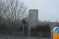
English: Colney is a village and parish on the western outskirts of Norwich in Norfolk, England. It is situated in the administrative district of South Norfolk. It covers an area of 917 acres (William White's History, Gazetteer, and Directory of Norfolk 1845) and had a population of 124 in 35 households at the 2001 census.
Norsk bokmål: Colney er en landsby som ligger i den vestre utkanten av Norwich i Norfolk i England. Landsbyen ligger under det administrative distriktet South Norfolk. Elven Yare renner gjennom Colney.
village in the western outskirts of Norwich in Norfolk, England  | |||||
| Upload media | |||||
| Instance of | |||||
|---|---|---|---|---|---|
| Location | South Norfolk, Norfolk, East of England, England | ||||
| Area |
| ||||
| Said to be the same as | Colney (Wikimedia duplicated page, civil parish) | ||||
 | |||||
Subcategories
This category has the following 7 subcategories, out of 7 total.
A
C
- Colney Hall, Colney, Norfolk (3 F)
- Colney Village Hall (6 F)
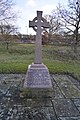
- Colney War Memorial (4 F)
E
- Environs of Colney (1 F)
N
S
- Structures in Colney (1 F)
Media in category "Colney"
The following 200 files are in this category, out of 464 total.
(previous page) (next page)-
 A boathouse once stood here - geograph.org.uk - 4858671.jpg 640 × 414; 439 KB
-

-
 A deserted B1108 - geograph.org.uk - 3183595.jpg 640 × 430; 60 KB
-
 A flooded River Yare - geograph.org.uk - 4858632.jpg 640 × 360; 302 KB
-
 A grave marker with a difference - geograph.org.uk - 4861828.jpg 640 × 565; 537 KB
-

-
 A path at GreenAcres - geograph.org.uk - 4858588.jpg 360 × 640; 390 KB
-
 A ^ E Department ^ Car Park - geograph.org.uk - 3869641.jpg 2,989 × 2,240; 1.9 MB
-
 A47, Heathersett Lane Bridge - geograph.org.uk - 2704338.jpg 640 × 376; 50 KB
-
 A47, Norwich bypass - geograph.org.uk - 4391550.jpg 640 × 426; 38 KB
-
 A47, Norwich bypass - geograph.org.uk - 4391554.jpg 640 × 426; 59 KB
-
 Accident ^ Emergency entrance - geograph.org.uk - 3416705.jpg 3,072 × 2,304; 1.29 MB
-
 Along the northern edge of Colney Wood - geograph.org.uk - 4861714.jpg 640 × 360; 273 KB
-
 Ancient oak tree beside the River Yare - geograph.org.uk - 4858626.jpg 640 × 360; 400 KB
-
 Andrew Street - geograph.org.uk - 4861808.jpg 625 × 640; 673 KB
-
 Anglia Water - geograph.org.uk - 3805318.jpg 640 × 430; 121 KB
-
 Anonymous entrance - geograph.org.uk - 4896449.jpg 640 × 455; 231 KB
-
 Approaching the B1108 - geograph.org.uk - 1973430.jpg 640 × 430; 116 KB
-
 Approaching the Colney Lane roundabout - geograph.org.uk - 3869714.jpg 2,952 × 2,212; 859 KB
-
 Arable land by B1108 - geograph.org.uk - 3824507.jpg 640 × 430; 51 KB
-
 Avenue of trees - geograph.org.uk - 2699814.jpg 640 × 430; 83 KB
-
 B1108 (Watton Road), Colney - geograph.org.uk - 4890443.jpg 640 × 480; 302 KB
-
 B1108 Watton Road - geograph.org.uk - 1995458.jpg 3,072 × 2,304; 1.34 MB
-
 B1108 Watton Road ^ Colney Village Sign - geograph.org.uk - 1995444.jpg 3,072 × 2,304; 1.28 MB
-
 B1108 Watton Road, Colney - geograph.org.uk - 4161659.jpg 3,072 × 2,304; 1.73 MB
-
 B1108, Colney - geograph.org.uk - 3183586.jpg 640 × 430; 47 KB
-
 B1108, Watton Rd - geograph.org.uk - 3368440.jpg 640 × 430; 86 KB
-
 B1108, Watton Rd - geograph.org.uk - 3368447.jpg 640 × 469; 80 KB
-
 B1108, Watton Rd - geograph.org.uk - 4335057.jpg 640 × 430; 45 KB
-
 B1108, Watton Rd - geograph.org.uk - 4335060.jpg 640 × 430; 45 KB
-
 B1108, Watton Rd - geograph.org.uk - 4335069.jpg 640 × 430; 48 KB
-
 B1108, westward - geograph.org.uk - 3183592.jpg 640 × 430; 53 KB
-
 Barn, Hall Farm - geograph.org.uk - 3183589.jpg 640 × 430; 51 KB
-
 Beech trees at GreenAcres - geograph.org.uk - 4858564.jpg 360 × 640; 405 KB
-
 Between the River Yare and Colney Wood - geograph.org.uk - 4861705.jpg 640 × 360; 274 KB
-
 Bob Champion Research ^ Education Building - geograph.org.uk - 4411000.jpg 3,072 × 2,304; 1.79 MB
-
 Bob Champion Research ^ Education Building sign - geograph.org.uk - 4411006.jpg 3,072 × 2,304; 2.47 MB
-
 Bowthorpe Southern Park - geograph.org.uk - 27709.jpg 640 × 480; 97 KB
-
 Brambles and lichen-covered shrubs - geograph.org.uk - 4858672.jpg 360 × 640; 403 KB
-
 Braymeadow Lane - geograph.org.uk - 1995153.jpg 3,072 × 2,304; 1.46 MB
-
 Brick-built tank in the floodwater - geograph.org.uk - 4858663.jpg 640 × 528; 526 KB
-
 Building Work at the Norfolk ^ Norwich University Hospitals - geograph.org.uk - 3869659.jpg 3,072 × 2,304; 1.13 MB
-
 By the River Yare at Colney - geograph.org.uk - 4861707.jpg 640 × 360; 257 KB
-
 Car Park - geograph.org.uk - 3922441.jpg 640 × 480; 65 KB
-
 Car Park entrance - geograph.org.uk - 3755971.jpg 3,072 × 2,304; 1.9 MB
-
 Carved into an old brick - geograph.org.uk - 4861776.jpg 640 × 483; 513 KB
-
 Chancellors Drive - geograph.org.uk - 673645.jpg 640 × 480; 65 KB
-
 Church Farm - geograph.org.uk - 2699983.jpg 640 × 430; 56 KB
-
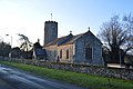
 Church of St Andrew - geograph.org.uk - 3299588.jpg 640 × 430; 60 KB
-
 Church of St Andrew - geograph.org.uk - 3321519.jpg 640 × 430; 62 KB
-
 Church of St Andrew - geograph.org.uk - 3321522.jpg 430 × 640; 61 KB
-
 Church of St Andrew - geograph.org.uk - 3321631.jpg 640 × 430; 98 KB
-
 Church of St Andrew - geograph.org.uk - 3803069.jpg 430 × 640; 66 KB
-
 Church of St Andrew - geograph.org.uk - 3805299.jpg 640 × 418; 73 KB
-
 Church of St Andrew - geograph.org.uk - 3805300.jpg 640 × 430; 90 KB
-
 Church of St Andrew - geograph.org.uk - 4373768.jpg 640 × 426; 67 KB
-
 Church of St Andrew - geograph.org.uk - 4399419.jpg 640 × 426; 72 KB
-
 Church of St Andrew - geograph.org.uk - 4399425.jpg 640 × 426; 79 KB
-
 Church of St Andrew - geograph.org.uk - 4399427.jpg 426 × 640; 79 KB
-
 Church of St Andrew - geograph.org.uk - 4399432.jpg 426 × 640; 77 KB
-
 Church of St Andrew - geograph.org.uk - 4399435.jpg 640 × 426; 88 KB
-

-
 Church of St Andrew graveyard - geograph.org.uk - 3803073.jpg 640 × 430; 100 KB
-
 Circus Berlin poster - geograph.org.uk - 4890449.jpg 628 × 640; 457 KB
-
 Circus Berlin poster - geograph.org.uk - 4890452.jpg 596 × 640; 571 KB
-
 Colney Hall - geograph.org.uk - 3416759.jpg 2,914 × 2,189; 883 KB
-
 Colney Hall - geograph.org.uk - 3416761.jpg 2,914 × 2,189; 1.08 MB
-
 Colney Hall sign - geograph.org.uk - 3413244.jpg 2,304 × 3,072; 1.49 MB
-
 Colney Lane - geograph.org.uk - 1400405.jpg 640 × 430; 105 KB
-
 Colney Lane - geograph.org.uk - 2704321.jpg 640 × 503; 91 KB
-
 Colney Lane - geograph.org.uk - 3321636.jpg 640 × 430; 87 KB
-
 Colney Lane - geograph.org.uk - 3803033.jpg 640 × 430; 92 KB
-
 Colney Lane - geograph.org.uk - 3803034.jpg 640 × 430; 60 KB
-
 Colney Lane - geograph.org.uk - 3803048.jpg 640 × 430; 77 KB
-
 Colney Lane Playing Fields - geograph.org.uk - 4268205.jpg 3,072 × 2,304; 1.82 MB
-
 Colney Lane Playing Fields Car Park - geograph.org.uk - 4268208.jpg 3,072 × 2,304; 1.92 MB
-
 Colney Lane Playing Fields Pavilion - geograph.org.uk - 4268199.jpg 3,072 × 2,304; 1.94 MB
-
 Colney Lane, Colney - geograph.org.uk - 3869663.jpg 3,072 × 2,304; 1.24 MB
-
 Colney Lane, Colney - geograph.org.uk - 3869687.jpg 3,072 × 2,304; 1.06 MB
-
 Colney Lane, Colney - geograph.org.uk - 4161644.jpg 3,072 × 2,304; 1.69 MB
-
 Colney Lane, Colney - geograph.org.uk - 4161652.jpg 3,072 × 2,304; 2.05 MB
-
 Colney Lane, Colney - geograph.org.uk - 4203242.jpg 3,072 × 2,304; 1.78 MB
-
 Colney Lane, Colney - geograph.org.uk - 4411015.jpg 3,072 × 2,304; 1.71 MB
-
 Colney Parish Hall - geograph.org.uk - 3207151.jpg 640 × 430; 54 KB
-
 Colney Parish Room - geograph.org.uk - 2703131.jpg 640 × 430; 83 KB
-
 Colney Village Sign - geograph.org.uk - 1995445.jpg 2,304 × 3,072; 1.23 MB
-
 Colney Village Sign - geograph.org.uk - 1995449.jpg 3,072 × 2,304; 1.13 MB
-
 Colney Village sign - geograph.org.uk - 2703105.jpg 640 × 430; 79 KB
-
 Colney Village Sign - geograph.org.uk - 3299582.jpg 640 × 430; 91 KB
-
 Colney Village sign - geograph.org.uk - 4391563.jpg 640 × 426; 87 KB
-
 Colney War Memorial - geograph.org.uk - 2699950.jpg 640 × 430; 101 KB
-
 Colney War Memorial - geograph.org.uk - 2700026.jpg 640 × 430; 94 KB
-
 Colney War Memorial - geograph.org.uk - 3321516.jpg 430 × 640; 86 KB
-
 Colney War Memorial - geograph.org.uk - 3805305.jpg 430 × 640; 89 KB
-
 Colney War Memorial - geograph.org.uk - 4391566.jpg 426 × 640; 106 KB
-
 Colney Woodland Burial Ground - geograph.org.uk - 3299595.jpg 640 × 430; 87 KB
-
 Colney Woodland Burial Park - geograph.org.uk - 2595469.jpg 640 × 430; 118 KB
-
 Colney Woodland Burial Park sign - geograph.org.uk - 3412555.jpg 2,304 × 3,072; 1.58 MB
-
 Concrete block beside boathouse remains - geograph.org.uk - 4861763.jpg 360 × 640; 347 KB
-
 Conifers at GreenAcres - geograph.org.uk - 4858556.jpg 640 × 360; 382 KB
-
 Conservation area north of Colney Wood - geograph.org.uk - 4858628.jpg 640 × 360; 277 KB
-
 Conservation area north of Colney Wood - geograph.org.uk - 4858634.jpg 640 × 360; 292 KB
-
 Conservation area north of Colney Wood - geograph.org.uk - 4861675.jpg 640 × 360; 293 KB
-
 Cotman Centre - geograph.org.uk - 3321640.jpg 640 × 430; 51 KB
-
 Cotman Centre - geograph.org.uk - 3321645.jpg 640 × 430; 91 KB
-
 Cotman Centre - geograph.org.uk - 3803043.jpg 640 × 399; 82 KB
-
 Cotman Centre, Norwich Research Park - geograph.org.uk - 2699851.jpg 640 × 430; 75 KB
-
 Cotman Centre, Norwich Research Park - geograph.org.uk - 2699854.jpg 640 × 347; 55 KB
-
 Cottages, Old Watton Rd - geograph.org.uk - 1390824.jpg 640 × 430; 79 KB
-

-

-

-
 Cricket scoreboard - geograph.org.uk - 4857441.jpg 1,600 × 1,200; 476 KB
-
 Damselfly by the River Yare - geograph.org.uk - 2433534.jpg 694 × 521; 140 KB
-
 Damselfly by the River Yare - geograph.org.uk - 2433719.jpg 1,115 × 831; 251 KB
-
 Damselfly on the R. Yare - geograph.org.uk - 2418327.jpg 930 × 606; 185 KB
-
 Disused electricity substation - geograph.org.uk - 4896600.jpg 640 × 480; 375 KB
-
 Driveway to Colney Hall - geograph.org.uk - 3299593.jpg 640 × 430; 91 KB
-
 Earlham Rd - geograph.org.uk - 3207155.jpg 640 × 430; 76 KB
-
 Electricity Sub-Station - geograph.org.uk - 4399444.jpg 640 × 426; 66 KB
-
 Electricity Sub-Station - geograph.org.uk - 4399445.jpg 640 × 426; 54 KB
-
 Electricity Sub-Station and pylons - geograph.org.uk - 4399448.jpg 640 × 426; 60 KB
-
 Electricity substation - geograph.org.uk - 4896603.jpg 640 × 480; 411 KB
-
 Entering Colney - geograph.org.uk - 1390717.jpg 640 × 430; 98 KB
-
 Entering Colney - geograph.org.uk - 1973402.jpg 640 × 430; 150 KB
-
 Entering Colney - geograph.org.uk - 3207147.jpg 640 × 430; 81 KB
-
 Entering Colney, B1108 - geograph.org.uk - 4331469.jpg 640 × 430; 74 KB
-
 Entering Colney, B1108 - geograph.org.uk - 4373414.jpg 640 × 426; 50 KB
-
 Entrance drive to Colney Hall - geograph.org.uk - 6001768.jpg 4,608 × 3,456; 6.2 MB
-
 Entrance of W H Smith shop - geograph.org.uk - 5895842.jpg 870 × 1,527; 738 KB
-
 Entrance path to Colney Lane Playing Fields - geograph.org.uk - 4268204.jpg 3,072 × 2,304; 1.96 MB
-
 Entrance porch, Church of St Andrew - geograph.org.uk - 4399430.jpg 426 × 640; 108 KB
-
 Entrance to Colney Hall - geograph.org.uk - 3413247.jpg 3,072 × 2,304; 1.64 MB
-
 Entrance to Colney Old Hall - geograph.org.uk - 2595474.jpg 640 × 317; 70 KB
-
 Entrance to Colney Woodland Burial Park - geograph.org.uk - 3412554.jpg 3,072 × 2,023; 2.09 MB
-
 Entrance to electricity substation - geograph.org.uk - 4896608.jpg 640 × 511; 486 KB
-
 Entrance to Old Hall Mews - geograph.org.uk - 4890466.jpg 640 × 480; 399 KB
-
 Entrance to Spire - geograph.org.uk - 1973422.jpg 640 × 430; 155 KB
-
 Entrance to West Outpatients - geograph.org.uk - 5895845.jpg 912 × 1,600; 529 KB
-
 Farm buildings at Colney - geograph.org.uk - 4896587.jpg 640 × 581; 481 KB
-
 Farm buildings by Watton Rd - geograph.org.uk - 2595472.jpg 640 × 430; 71 KB
-
 Farmland by School Lane - geograph.org.uk - 3185069.jpg 640 × 430; 58 KB
-
 Farmland by School Lane - geograph.org.uk - 3185077.jpg 640 × 430; 50 KB
-
 Field of vegetables by the B1108 - geograph.org.uk - 2704325.jpg 640 × 388; 89 KB
-
 Flood on the River Yare - geograph.org.uk - 4858650.jpg 640 × 360; 270 KB
-
 Flood plain of the River Yare - geograph.org.uk - 2703153.jpg 640 × 430; 82 KB
-
 Flood plain of the River Yare - geograph.org.uk - 2703161.jpg 640 × 430; 74 KB
-
 Flooded conservation area at Colney - geograph.org.uk - 4858639.jpg 640 × 360; 287 KB
-
 Flooded meadow in Colney - geograph.org.uk - 4858647.jpg 640 × 440; 375 KB
-
 Flooding by Colney Hall - geograph.org.uk - 4858655.jpg 640 × 360; 249 KB
-
 Flooding by Colney Hall - geograph.org.uk - 4858659.jpg 640 × 360; 272 KB
-
 Flooding by Summer House Plantation - geograph.org.uk - 4858657.jpg 640 × 360; 286 KB
-
 Flooding north of Colney Hall - geograph.org.uk - 4858658.jpg 640 × 360; 280 KB
-
 Flooding on the River Yare - geograph.org.uk - 4858654.jpg 640 × 360; 277 KB
-
 Football pitch by UEA - geograph.org.uk - 4857426.jpg 1,600 × 1,200; 476 KB
-
 Forge Cottage - geograph.org.uk - 3321502.jpg 640 × 430; 92 KB
-
 Forge Cottage - geograph.org.uk - 4391565.jpg 640 × 426; 86 KB
-
 Gate into GreenAcres - geograph.org.uk - 4858560.jpg 640 × 360; 365 KB
-
 Gated road, Colney - geograph.org.uk - 3321508.jpg 640 × 430; 69 KB
-

-
 Gnarled old oak by the River Yare - geograph.org.uk - 4858627.jpg 640 × 360; 342 KB
-
 Grassland - geograph.org.uk - 3803014.jpg 640 × 430; 53 KB
-
 Grassland by UEA - geograph.org.uk - 4857433.jpg 1,600 × 1,200; 371 KB
-
 Grassy meadow by the River Yare - geograph.org.uk - 3323276.jpg 640 × 430; 73 KB
-
 Grave marker at GreenAcres - geograph.org.uk - 4858579.jpg 640 × 408; 393 KB
-
 Grave marker at GreenAcres - geograph.org.uk - 4861815.jpg 628 × 640; 666 KB
-
 Grave markers at GreenAcres - geograph.org.uk - 4858585.jpg 640 × 573; 579 KB
-
 Grave of Joseph Scott, Colney - geograph.org.uk - 3805302.jpg 640 × 430; 100 KB
-

-

-
 Graves with a view - geograph.org.uk - 4858563.jpg 640 × 360; 277 KB
-
 Gravestones, Church of St Andrew - geograph.org.uk - 3321625.jpg 640 × 430; 92 KB
-
 Gravestones, Church of St Andrew - geograph.org.uk - 3321628.jpg 640 × 430; 102 KB
-
 Green hillside with trees at GreenAcres - geograph.org.uk - 4858571.jpg 640 × 360; 396 KB
-
 GreenAcres woodland burial ground - geograph.org.uk - 4856080.jpg 640 × 480; 303 KB
-
 GreenAcres woodland burial ground - geograph.org.uk - 4856087.jpg 640 × 480; 292 KB
-
 GreenAcres woodland burial ground - geograph.org.uk - 4858572.jpg 640 × 360; 391 KB
-
 Hall Farm - geograph.org.uk - 3183590.jpg 640 × 430; 52 KB
-
 Hall Farm, Colney - geograph.org.uk - 4890467.jpg 640 × 480; 331 KB
-
 He travelled, educated and loved - geograph.org.uk - 4861801.jpg 573 × 640; 560 KB
-
 Heathersett Lane - geograph.org.uk - 3183588.jpg 640 × 430; 54 KB
-
 Heathersett Lane Bridge, A47 - geograph.org.uk - 2595462.jpg 640 × 430; 61 KB
-
 Heathersett Lane Bridge, A47 - geograph.org.uk - 3368427.jpg 640 × 430; 62 KB
-
 Heathersett Lane Bridge, A47 - geograph.org.uk - 3371996.jpg 640 × 555; 73 KB
-
 Heathersett Lane Bridge, A47 - geograph.org.uk - 3803184.jpg 640 × 430; 54 KB
-
 Hethersett Lane - geograph.org.uk - 1995119.jpg 3,072 × 2,304; 1.25 MB
-
 Hethersett Lane - geograph.org.uk - 1995131.jpg 3,072 × 2,304; 1.35 MB
-
 Hethersett Lane - geograph.org.uk - 1995133.jpg 3,072 × 2,304; 1.39 MB
-
 Hethersett Lane - geograph.org.uk - 1995385.jpg 3,072 × 2,304; 1.22 MB
-
 Hethersett Lane - geograph.org.uk - 1995386.jpg 3,072 × 2,304; 1.3 MB
-
 Hethersett Lane Bridge, A47 - geograph.org.uk - 4391553.jpg 640 × 426; 50 KB
-
 Hiding in dense vegetation - geograph.org.uk - 4896591.jpg 640 × 480; 442 KB
-

-
 House on Old Watton Rd - geograph.org.uk - 2703116.jpg 640 × 430; 65 KB
-
 House on Old Watton Rd - geograph.org.uk - 3805331.jpg 640 × 430; 101 KB
-
 Houses, Old Watton Rd - geograph.org.uk - 3805325.jpg 640 × 430; 91 KB
-
 Initials carved into bricks - geograph.org.uk - 4861780.jpg 640 × 360; 389 KB
-
 Institute of Food Research - geograph.org.uk - 3323274.jpg 640 × 430; 62 KB
-

-


,_Colney_-_geograph.org.uk_-_4890443.jpg)


