Category:Claybrooke Parva
Jump to navigation
Jump to search
village in the United Kingdom | |||||
| Upload media | |||||
| Instance of | |||||
|---|---|---|---|---|---|
| Location | Harborough, Leicestershire, East Midlands, England | ||||
| Population |
| ||||
| Area |
| ||||
 | |||||
English: Claybrooke Parva is a village in South West Leicestershire, England close to Claybrooke Magna. The village is the site of a church which is thought to originally be part Anglo Saxon with Norman and Medieval additions.
Subcategories
This category has only the following subcategory.
P
Media in category "Claybrooke Parva"
The following 61 files are in this category, out of 61 total.
-
 A5 near Wibtoft - geograph.org.uk - 4708691.jpg 640 × 426; 47 KB
-
 A5 northbound at Woodway Lane - geograph.org.uk - 4876070.jpg 640 × 480; 49 KB
-

-
 A5, southbound - geograph.org.uk - 4708687.jpg 640 × 426; 43 KB
-
 A5, southbound - geograph.org.uk - 4708694.jpg 640 × 426; 61 KB
-
 Alma House near Wiboft - geograph.org.uk - 2040074.jpg 1,024 × 768; 121 KB
-
 Avenue Villas, Claybrooke Parva - geograph.org.uk - 888100.jpg 480 × 640; 99 KB
-
 Bench mark, St Peter's Church, Claybrooke Parva - geograph.org.uk - 4956195.jpg 853 × 1,280; 492 KB
-
 Benchmark on St Peter's Church - geograph.org.uk - 4501583.jpg 2,560 × 1,920; 1.04 MB
-
 Church of St Peter, Claybrooke Parva - geograph.org.uk - 4956196.jpg 1,280 × 876; 429 KB
-
 Church of St Peter, Claybrooke Parva - geograph.org.uk - 4956203.jpg 1,280 × 801; 336 KB
-
 Church of St Peter, Claybrooke Parva - geograph.org.uk - 4956204.jpg 841 × 1,280; 380 KB
-
 Church of St Peter, Claybrooke Parva - geograph.org.uk - 4956217.jpg 1,280 × 903; 281 KB
-
 Church of St Peter, Claybrooke Parva - geograph.org.uk - 4956219.jpg 1,280 × 906; 367 KB
-
 Church of St Peter, Claybrooke Parva - geograph.org.uk - 4956220.jpg 863 × 1,280; 270 KB
-
 Church of St Peter, Claybrooke Parva - geograph.org.uk - 4956221.jpg 963 × 1,280; 226 KB
-
 Church of St Peter, Claybrooke Parva - geograph.org.uk - 4956222.jpg 1,280 × 1,021; 299 KB
-
 Church of St Peter, Claybrooke Parva - geograph.org.uk - 4956223.jpg 1,280 × 897; 230 KB
-
 Church of St Peter, Claybrooke Parva - geograph.org.uk - 4956396.jpg 1,280 × 919; 257 KB
-
 Church of St Peter, Claybrooke Parva - geograph.org.uk - 4956397.jpg 850 × 1,280; 273 KB
-
 Church of St Peter, Claybrooke Parva - geograph.org.uk - 4956399.jpg 853 × 1,280; 371 KB
-
 Church of St Peter, Claybrooke Parva - geograph.org.uk - 4956401.jpg 853 × 1,280; 276 KB
-
 Church of St Peter, Claybrooke Parva - geograph.org.uk - 4956402.jpg 813 × 1,280; 248 KB
-
 Church of St Peter, Claybrooke Parva - geograph.org.uk - 4956403.jpg 853 × 1,280; 478 KB
-
 Church of St Peter, Claybrooke Parva - geograph.org.uk - 4956405.jpg 879 × 1,280; 475 KB
-
 Church of St Peter, Claybrooke Parva - geograph.org.uk - 4956408.jpg 1,280 × 853; 406 KB
-
 Church of St Peter, Claybrooke Parva - geograph.org.uk - 4956410.jpg 1,280 × 1,280; 638 KB
-
 Church of St Peter, Claybrooke Parva - geograph.org.uk - 4956412.jpg 931 × 1,280; 500 KB
-
 Church of St Peter, Claybrooke Parva - geograph.org.uk - 4956413.jpg 853 × 1,280; 457 KB
-
 Church of St Peter, Claybrooke Parva - geograph.org.uk - 4956415.jpg 1,280 × 870; 548 KB
-
 Church of St Peter, Claybrooke Parva - geograph.org.uk - 4956416.jpg 1,280 × 853; 467 KB
-
 Church of St Peter, Claybrooke Parva - geograph.org.uk - 4956420.jpg 1,280 × 1,280; 494 KB
-
 Church of St Peter, Claybrooke Parva - geograph.org.uk - 4956421.jpg 1,280 × 1,280; 746 KB
-
 Church of St Peter, Claybrooke Parva - geograph.org.uk - 4956422.jpg 836 × 1,280; 358 KB
-
 Church of St Peter, Claybrooke Parva - geograph.org.uk - 4956424.jpg 1,280 × 891; 294 KB
-
 Claybrooke Hall - geograph.org.uk - 4956449.jpg 1,280 × 853; 449 KB
-
 Claybrooke Hall - geograph.org.uk - 626755.jpg 640 × 396; 108 KB
-
 Entrance to Claybrooke Parva - geograph.org.uk - 3568736.jpg 640 × 480; 85 KB
-
 Former B577, Claybrooke Parva - geograph.org.uk - 4956193.jpg 1,280 × 853; 422 KB
-
 High Cross (Venonis) - geograph.org.uk - 2598213.jpg 4,000 × 3,000; 2.87 MB
-
 High Cross - geograph.org.uk - 2040106.jpg 1,024 × 768; 185 KB
-
 High Cross Road - geograph.org.uk - 3155861.jpg 640 × 480; 73 KB
-
 Horse and Church - geograph.org.uk - 626751.jpg 640 × 520; 99 KB
-
 Large house, High Cross - geograph.org.uk - 3155846.jpg 640 × 345; 44 KB
-
 Milepost and Church - geograph.org.uk - 626749.jpg 640 × 489; 113 KB
-
 Milepost, Claybrooke Parva - geograph.org.uk - 4956192.jpg 853 × 1,280; 593 KB
-
 Roman roads meet at High Cross - geograph.org.uk - 6238203.jpg 1,024 × 500; 248 KB
-
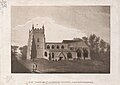 S. W. View of Claybrook Church, Leicestershire.jpg 976 × 693; 190 KB
-
 Shady sheep - geograph.org.uk - 184011.jpg 640 × 480; 298 KB
-
 The A5 at High Cross - geograph.org.uk - 3155854.jpg 640 × 480; 67 KB
-
 The A5 at High Cross - geograph.org.uk - 4171324.jpg 1,600 × 1,258; 568 KB
-
 The A5 at High Cross - geograph.org.uk - 5300543.jpg 4,128 × 2,322; 3.99 MB
-
 The approach to Claybrooke Parva - geograph.org.uk - 5300647.jpg 2,322 × 4,128; 2.2 MB
-
 View towards Magna Park - geograph.org.uk - 619274.jpg 640 × 428; 83 KB
-
 Woodway Lane - geograph.org.uk - 5371180.jpg 4,128 × 2,322; 4.35 MB
-
 A5 Watling Street - geograph.org.uk - 619279.jpg 640 × 433; 79 KB
-
 Ashby Parva - geograph.org.uk - 156073.jpg 640 × 480; 142 KB
-
 Claybrooke Magna - geograph.org.uk - 134510.jpg 640 × 480; 118 KB
-
 Claybrooke Parva - geograph.org.uk - 626727.jpg 640 × 454; 119 KB
-
 Northwest along the A5 Watling Street - geograph.org.uk - 619547.jpg 640 × 480; 67 KB
-
 Public Bridleway to Claybrooke Parva - geograph.org.uk - 619553.jpg 476 × 640; 91 KB


_-_geograph.org.uk_-_2598213.jpg)


