Category:Claridenhütte
Jump to navigation
Jump to search
| Object location | | View all coordinates using: OpenStreetMap |
|---|
  | |||||
| Upload media | |||||
| Instance of | |||||
|---|---|---|---|---|---|
| Location | Glarus, Switzerland | ||||
| Owned by | |||||
| Inception |
| ||||
| Mountain range | |||||
| Elevation above sea level |
| ||||
| official website | |||||
 | |||||
English: Claridenhütte, an alpine hut of the Swiss Alpine Club (SAC) in the canton of Glarus, Switzerland
Media in category "Claridenhütte"
The following 12 files are in this category, out of 12 total.
-
 0x-claridenh.jpg 1,600 × 1,200; 299 KB
-
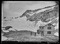 CH-NB Photoglob-Wehrli EAD-WEHR-8975-B.tif 7,494 × 5,584, 2 pages; 79.88 MB
-
 Claridenhütte as seen from Gemsalpeli.jpg 5,184 × 3,176; 4.25 MB
-
 Claridenhütte as seen from Northeast.jpg 2,262 × 2,184; 1.05 MB
-
 Claridenhütte from West.jpg 4,032 × 3,024; 4.89 MB
-
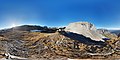 Claridenhütte Spherical Panorama.jpg 10,240 × 5,120; 13.63 MB
-
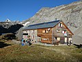 Claridenhütte.jpg 5,184 × 3,888; 8.39 MB
-
 Claridenhütte1.jpg 748 × 525; 48 KB
-
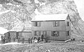
 ETH-BIB-Claridenhütte 1898-Ans 15809-000-P02-AL.tif 2,608 × 1,908; 14.25 MB
-
 Gemsfairenstock as seen from Claridenhütte.jpg 5,167 × 3,289; 6.37 MB
-
 View on the sea of fog below Claridenhütte.jpg 4,032 × 3,024; 2.87 MB
-
 Zweite Claridenhütte.jpg 679 × 422; 164 KB


