Category:Church in Zaschendorf
Jump to navigation
Jump to search
| Object location | | View all coordinates using: OpenStreetMap |
|---|
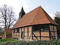
church building in Kuhlen-Wendorf, Germany  | |||||
| Upload media | |||||
| Instance of | |||||
|---|---|---|---|---|---|
| Location | Kuhlen-Wendorf, Ludwigslust-Parchim District, Mecklenburg-Western Pomerania, Germany | ||||
 | |||||
Media in category "Church in Zaschendorf"
The following 10 files are in this category, out of 10 total.
-
 Zaschendorf Kirche 2009-04-16 080.jpg 1,536 × 2,048; 1.9 MB
-
 Zaschendorf Kirche 2013-04-25 367.JPG 1,944 × 2,592; 2.98 MB
-
 Zaschendorf Kirche 2013-04-25 368.JPG 1,944 × 2,592; 2.83 MB
-
 Zaschendorf Kirche 2013-04-25 369.JPG 1,944 × 2,592; 2.86 MB
-
 Zaschendorf Kirche 2013-04-25 370.JPG 1,944 × 2,592; 2.74 MB
-
 Zaschendorf Kirche 2013-04-25 375.JPG 2,592 × 1,944; 3.01 MB
-
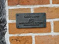 Zaschendorf Kirche Plakette Deutsche Stiftung Denkmalschutz 2013-04-25 374.JPG 2,592 × 1,944; 3.02 MB
-
 Zaschendorf Kirche Trockenmauer 2013-04-25 371.JPG 1,944 × 2,592; 3.03 MB
-
 Zaschendorf Kirche Turm 2013-04-25 372.JPG 1,944 × 2,592; 2.64 MB
-
 Zaschendorf Kirche Tür 2013-04-25 373.JPG 1,944 × 2,592; 3.01 MB


Categories:
- Churches in Kuhlen-Wendorf
- Churches in Propstei Wismar
- Timber framed brick churches in Landkreis Ludwigslust-Parchim
- 17th-century timber framed brick churches in Mecklenburg-Vorpommern
- Zaschendorf (Kuhlen-Wendorf)
- Cultural heritage monuments in Kuhlen-Wendorf
- Lutheran churches in Landkreis Ludwigslust-Parchim