Category:Church in Kotelow
Jump to navigation
Jump to search
| Object location | | View all coordinates using: OpenStreetMap |
|---|
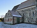
church in Kotelow, Germany  | |||||
| Upload media | |||||
| Instance of | |||||
|---|---|---|---|---|---|
| Location | Galenbeck, Mecklenburgische Seenplatte District, Mecklenburg-Western Pomerania, Germany | ||||
| Heritage designation | |||||
 | |||||
Media in category "Church in Kotelow"
The following 6 files are in this category, out of 6 total.
-
 Kotelow Kirche eingeruestet 2011-01-28 239.JPG 1,944 × 2,592; 2.29 MB
-
 Kotelow Kirche eingeruestet 2011-01-28 240.JPG 1,944 × 2,592; 2.21 MB
-
 Kotelow Kirche eingeruestet 2011-01-28 241.JPG 2,592 × 1,944; 2.19 MB
-
 Kotelow Kirche eingeruestet 2011-01-28 242.JPG 2,592 × 1,944; 2.08 MB
-
 Kotelow Kirche eingeruestet 2011-01-28 247.JPG 1,944 × 2,592; 2.22 MB
-
 Kotelow Kirche Kreuz 2011-01-28 248.JPG 1,944 × 2,592; 2.28 MB


