Category:Cherwell Valley Line
Jump to navigation
Jump to search
The Cherwell Valley Line is a railway line in Oxfordshire and Northamptonshire, England. It links Didcot Parkway - Radley - Oxford - Banbury.
railway line in Oxfordshire   | |||||
| Upload media | |||||
| Instance of | |||||
|---|---|---|---|---|---|
| Part of |
| ||||
| Location | Oxfordshire, South East England, England | ||||
| Owned by | |||||
| Operator | |||||
| |||||
Subcategories
This category has the following 21 subcategories, out of 21 total.
A
- Appleford Railway Bridge (19 F)
- Appleford railway station (7 F)
- Aynho Junction (11 F)
B
C
- Culham railway station (43 F)
D
- Duke's Cut railway bridge (9 F)
H
- Heyford railway station (13 F)
- Hinksey Yard (37 F)
K
- Kidlington railway station (3 F)
- Kings Sutton railway station (28 F)
N
- Nuneham Railway Bridge (18 F)
O
- Oxford Canal Bridge 226A (2 F)
R
- Radley railway station (10 F)
- River Isis Bridge (rail) (15 F)
T
- Tackley railway station (11 F)
W
- Wolvercote Junction (7 F)
Media in category "Cherwell Valley Line"
The following 68 files are in this category, out of 68 total.
-
 2023-05-13 from NW cropped.jpg 1,600 × 812; 1.17 MB
-

-
-
 Appleford Sidings - geograph.org.uk - 1653930.jpg 640 × 414; 33 KB
-
 Snow covered rails on the Cherwell Valley Line.jpg 640 × 414; 28 KB
-
 Wagons on the Cripple Road - geograph.org.uk - 1654000.jpg 640 × 427; 61 KB
-
 Appleford level crossing.jpg 640 × 481; 44 KB
-
 Approaching Oxford Station - geograph.org.uk - 1500491.jpg 640 × 427; 84 KB
-
 B&ojr.png 903 × 1,437; 94 KB
-
 Hennef Way bridge in Banbury - geograph.org.uk - 1327724.jpg 640 × 409; 79 KB
-
 Banbury to Oxford railway line - geograph.org.uk - 464115.jpg 640 × 480; 126 KB
-

-
 Bridge over the railway at Enslow - geograph.org.uk - 1323696.jpg 640 × 413; 84 KB
-
 Castle Mill from Walton Well Road railway bridge, Oxford.jpg 4,288 × 3,216; 3.64 MB
-
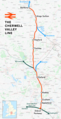 Cherwell Valley line.png 1,508 × 2,945; 2.4 MB
-
 Bridge over the line at Cropredy - geograph.org.uk - 1334841.jpg 640 × 427; 83 KB
-
 Crossovers at Tackley - geograph.org.uk - 1324818.jpg 640 × 427; 90 KB
-
 Didcot MMB 01 Foxhall Junction.jpg 4,365 × 2,439; 5.48 MB
-

-

-

-
 Wolvercote Viaduct - geograph.org.uk - 1321942.jpg 640 × 419; 72 KB
-

-
 Graduate housing from Walton Well Road Bridge, Oxford.JPG 4,288 × 3,216; 3.5 MB
-
 Graffiti covered bridge in Aristotle Lane - geograph.org.uk - 1758148.jpg 1,500 × 1,000; 156 KB
-
 Heading up to Oxford station - geograph.org.uk - 1085376.jpg 640 × 480; 97 KB
-

-
 Sandford Lane - geograph.org.uk - 1085531.jpg 640 × 480; 116 KB
-
 Railway Line to Birmingham - geograph.org.uk - 966660.jpg 640 × 480; 71 KB
-

-
 Sparrowgap Bridge over the railway - geograph.org.uk - 1322015.jpg 640 × 413; 72 KB
-
 Looking down the line to Aristotle Lane bridge - geograph.org.uk - 1760225.jpg 1,500 × 1,000; 323 KB
-
 Looking south from Godstow Road - geograph.org.uk - 4711565.jpg 1,280 × 960; 661 KB
-

-
 Freshly ballasted track at Oxford North - geograph.org.uk - 1758126.jpg 1,500 × 978; 203 KB
-
 Looking towards Oxford North Junction - geograph.org.uk - 1758186.jpg 1,500 × 980; 333 KB
-
 Looking up the line to Walton Well Road Bridge - geograph.org.uk - 1758169.jpg 1,500 × 969; 353 KB
-
 Oxford Canal - geograph.org.uk - 1598662.jpg 640 × 480; 107 KB
-
 Oxford Cemetry Footbridge eastern steps.JPG 1,366 × 910; 479 KB
-
 Oxford North Jnc.JPG 1,246 × 899; 472 KB
-
 Oxford to Banbury railway line - geograph.org.uk - 464112.jpg 480 × 640; 112 KB
-
 Pillbox by the railway at Appleford - geograph.org.uk - 1353205.jpg 640 × 414; 103 KB
-

-
 Railway line from Godstow Road, Wolvercote 01.jpg 4,128 × 3,096; 6.42 MB
-
 Railway line from Godstow Road, Wolvercote 02.jpg 4,128 × 3,096; 6.39 MB
-
 Railway lines near Radley - geograph.org.uk - 110377.jpg 640 × 480; 253 KB
-
 Roundham level crossing - geograph.org.uk - 813347.jpg 640 × 471; 121 KB
-
 Sandy Lane Crossing - geograph.org.uk - 1321984.jpg 640 × 414; 82 KB
-
 Sandy Lane Crossing near Kidlington - geograph.org.uk - 1321988.jpg 640 × 406; 86 KB
-
 The disused Kirtlington Cement Works - geograph.org.uk - 1323685.jpg 640 × 460; 61 KB
-
 The disused Kirtlington Cement Works - geograph.org.uk - 1345692.jpg 640 × 427; 78 KB
-
 Shipton1.jpg 1,090 × 739; 170 KB
-
 Snow covered railway lines - geograph.org.uk - 1653854.jpg 640 × 415; 49 KB
-
 Wharf Farm Bridge - geograph.org.uk - 1325031.jpg 640 × 413; 65 KB
-

-
 The container crane in Appleford - geograph.org.uk - 1653950.jpg 640 × 409; 57 KB
-
 The flooded railway at Hinksey - geograph.org.uk - 1268170.jpg 640 × 427; 69 KB
-
 The railway flooded under Redbridge - geograph.org.uk - 1268183.jpg 640 × 427; 80 KB
-

-
 The ring road crosses the railway - geograph.org.uk - 1345736.jpg 640 × 419; 86 KB
-

-
 Tuckwell's crossing at Grandpont - geograph.org.uk - 1345733.jpg 640 × 416; 109 KB
-
 Bridge at Wolvercote - geograph.org.uk - 1345708.jpg 640 × 422; 82 KB
-
 Wolvercote Junction - geograph.org.uk - 1321949.jpg 640 × 412; 88 KB
-
-
 Woodstock Road bridge at Yarnton - geograph.org.uk - 1321960.jpg 640 × 412; 87 KB
-
 Yarnton Lane Crossing - geograph.org.uk - 1321961.jpg 640 × 420; 92 KB
-
 Yarnton Lane Crossing - geograph.org.uk - 1598494.jpg 640 × 480; 93 KB


