Category:Charlemont
Jump to navigation
Jump to search
Wikimedia disambiguation page | |||||
| Instance of | |||||
|---|---|---|---|---|---|
| Different from | |||||
| |||||
English: Charlemont (originally known in Irish as Achadh an Dá Chora) is a small village in County Armagh, Northern Ireland. It had a population of 150 people in the 2001 Census. It is situated within the Armagh City and District Council area. Charlemont Bridge joins the villages of Charlemont on the east bank of the River Blackwater and Moy on the west.
Subcategories
This category has only the following subcategory.
Media in category "Charlemont"
The following 21 files are in this category, out of 21 total.
-

-
 Brass Plate - geograph.org.uk - 197141.jpg 640 × 480; 162 KB
-

-
 Canary Orange Hall - geograph.org.uk - 600477.jpg 640 × 279; 23 KB
-
 Canary Road - geograph.org.uk - 600476.jpg 640 × 479; 59 KB
-
 Charlemont fort.jpg 600 × 385; 69 KB
-
 Charlemont, Co. Armagh.jpg 640 × 480; 50 KB
-
 Charlemont, MA, USA - panoramio.jpg 2,448 × 2,867; 2.39 MB
-
 College Lands Road, Charlemont - geograph.org.uk - 2452469.jpg 640 × 480; 59 KB
-
 Disused Church - geograph.org.uk - 197140.jpg 640 × 480; 153 KB
-
 Main Armagh to Dungannon Road - geograph.org.uk - 531620.jpg 640 × 480; 103 KB
-
 Millar's Hill Orange Hall - geograph.org.uk - 205170.jpg 640 × 480; 84 KB
-
 River Blackwater - geograph.org.uk - 511195.jpg 640 × 480; 96 KB
-
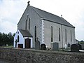 St Peter's Parish Church - geograph.org.uk - 196940.jpg 640 × 480; 99 KB
-
 Grange old Quaker Meeting house - geograph.org.uk - 600448.jpg 640 × 479; 91 KB
-
 Grange Quaker Meeting house - geograph.org.uk - 600446.jpg 640 × 479; 107 KB
-
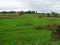
 Land south of Laghy Corner - geograph.org.uk - 600443.jpg 640 × 479; 47 KB
-
 Lisarnlet Townland - geograph.org.uk - 600452.jpg 640 × 479; 55 KB
-
 Lisloan Townland - geograph.org.uk - 600431.jpg 640 × 479; 75 KB
-
 Plaque, Religious Society of Friends - geograph.org.uk - 601398.jpg 640 × 479; 67 KB
-
 Shanmullagh Townland - geograph.org.uk - 600415.jpg 640 × 479; 67 KB
,_ff.38v-39_-_BL_Add_MS_24200.jpg)


