Category:Chapelle Notre Dame du Roure
Jump to navigation
Jump to search
| Object location | | View all coordinates using: OpenStreetMap |
|---|
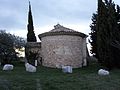
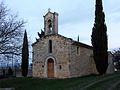
chapel located in Drôme, in France  | |||||
| Upload media | |||||
| Instance of | |||||
|---|---|---|---|---|---|
| Location | Tulette, canton of Saint-Paul-Trois-Châteaux, arrondissement of Montélimar, Drôme, Auvergne-Rhône-Alpes, Metropolitan France, France | ||||
 | |||||
Media in category "Chapelle Notre Dame du Roure"
The following 7 files are in this category, out of 7 total.
-
 Chapelle Notre Dame du Roure 1.JPG 4,608 × 3,456; 2.21 MB
-
 Chapelle Notre Dame du Roure 2.JPG 3,456 × 4,608; 2.4 MB
-
 Chapelle Notre Dame du Roure 3.JPG 3,456 × 4,608; 1.87 MB
-
 Chapelle Notre Dame du Roure 4.JPG 4,608 × 3,456; 2.22 MB
-
 Chapelle Notre Dame du Roure 5.JPG 3,456 × 4,608; 2.7 MB
-
 Chapelle Notre Dame du Roure 6.JPG 3,456 × 4,608; 1.99 MB
-
 Tulette (Drôme). - Vue Sud - Notre Dame du Roure (33760171323).jpg 3,450 × 2,253; 780 KB


._-_Vue_Sud_-_Notre_Dame_du_Roure_(33760171323).jpg)