Category:Chapel in Sławęcice
Jump to navigation
Jump to search
| Object location | | View all coordinates using: OpenStreetMap |
|---|
_ID_591049.jpg) | |||||
| Upload media | |||||
| Instance of | |||||
|---|---|---|---|---|---|
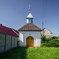
| Location | Sławęcice, Lower Silesian Voivodeship, Gmina Góra, Góra County, Lower Silesian Voivodeship, Poland | ||||
| Heritage designation |
| ||||
| Inception |
| ||||
 | |||||
Polski: Sławęcice, kapliczka, kon. XVIII w.
Media in category "Chapel in Sławęcice"
The following 2 files are in this category, out of 2 total.
-
 H.16.0642 - Sławęcice, kaplica.jpg 3,920 × 3,920; 4.24 MB
-
 SM Sławęcice kapliczka (1) ID 591049.jpg 2,996 × 2,996; 6.13 MB
