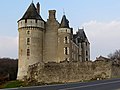
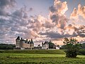
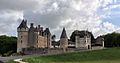
Category:Château de Montpoupon
Jump to navigation
Jump to search
| Object location | | View all coordinates using: OpenStreetMap |
|---|
|
This building is en partie classé, en partie inscrit au titre des monuments historiques de la France. It is indexed in the base Mérimée, a database of architectural heritage maintained by the French Ministry of Culture, under the reference PA00097620
|
castle  | |||||
| Upload media | |||||
| Instance of | |||||
|---|---|---|---|---|---|
| Location | |||||
| Owned by |
| ||||
| Founded by | |||||
| Heritage designation |
| ||||
| Inception |
| ||||
| official website | |||||
 | |||||
Subcategories
This category has only the following subcategory.
M
- Models of Château de Montpoupon (16 F)
Media in category "Château de Montpoupon"
The following 67 files are in this category, out of 67 total.
-
 7 Montpoupon (2) (13008744895).jpg 4,000 × 3,000; 2.41 MB
-
 7 Montpoupon (3) (13008739935).jpg 4,000 × 3,000; 1.68 MB
-
 7 Montpoupon (4) (13009120694).jpg 4,000 × 3,000; 2.59 MB
-
 7 Montpoupon (5) (13009115524).jpg 4,000 × 3,000; 2.43 MB
-
 7 Montpoupon (6) (13008875603).jpg 4,000 × 3,000; 2.66 MB
-
 7 Montpoupon (7) (13008869873).jpg 4,000 × 3,000; 1.6 MB
-
 Castle of Montpoupon 01.jpg 3,004 × 4,600; 8.6 MB
-
 Castle of Montpoupon 02.jpg 2,929 × 4,393; 7.87 MB
-
 Castle of Montpoupon 03.jpg 2,693 × 4,727; 7.05 MB
-
 Castle of Montpoupon 04.jpg 4,857 × 2,722; 9.34 MB
-
 Castle of Montpoupon 05.jpg 2,663 × 4,753; 7.62 MB
-
 Castle of Montpoupon 06.jpg 1,773 × 4,543; 5.99 MB
-
 Castle of Montpoupon 07.jpg 2,073 × 2,780; 3.52 MB
-
 Castle of Montpoupon 08.jpg 12,085 × 3,167; 19.08 MB
-
 Castle of Montpoupon 09.jpg 4,650 × 2,372; 8.58 MB
-
 Castle of Montpoupon 10.jpg 4,468 × 3,251; 7.27 MB
-
 Castle of Montpoupon 11.jpg 3,849 × 2,566; 5.88 MB
-
 Castle of Montpoupon 12.jpg 4,474 × 3,178; 9.02 MB
-
 Castle of Montpoupon 13.jpg 5,259 × 3,760; 11.35 MB
-
 Castle of Montpoupon 14.jpg 5,123 × 3,309; 11.3 MB
-
 Castle of Montpoupon 15.jpg 5,360 × 2,671; 7.45 MB
-
 Castle of Montpoupon 16.jpg 6,481 × 1,790; 7.09 MB
-
 Castle of Montpoupon 17.jpg 3,897 × 5,470; 11.98 MB
-
 Castle of Montpoupon 18.jpg 4,031 × 1,525; 4.66 MB
-
 Castle of Montpoupon 19.jpg 6,252 × 2,379; 7.24 MB
-
 Castle of Montpoupon 20.jpg 2,838 × 2,160; 4.11 MB
-
 Castle of Montpoupon 21.jpg 4,412 × 2,941; 6.06 MB
-
 Castle of Montpoupon 22.jpg 6,642 × 1,952; 11.56 MB
-
 Chambre de Madame.jpg 922 × 692; 151 KB
-
 Chambre du roi, château de Montpoupon.jpg 6,000 × 4,000; 11 MB
-
 Chateau de Monpoupon Southeast.jpg 3,008 × 2,000; 2.14 MB
-
 Chateau-de-montpoupon-chapelle.jpg 1,707 × 2,560; 707 KB
-
 Chateau-de-montpoupon-cuisine.jpg 2,560 × 1,920; 918 KB
-
 Chateau-de-montpoupon-ensoleille.jpg 2,763 × 1,843; 2.04 MB
-
 Chateau-de-montpoupon-venerie.jpg 1,707 × 2,560; 834 KB
-
 Château de Montpoupon (8859397760).jpg 3,220 × 1,696; 2.12 MB
-
 Château de Montpoupon - panoramio.jpg 700 × 432; 97 KB
-
 Château de Montpoupon - Vue Extérieure.JPG 1,024 × 501; 257 KB
-
 Château de Montpoupon.jpg 1,600 × 1,200; 683 KB
-
 Château-Montpoupon.jpg 1,701 × 1,061; 538 KB
-
 Cuisine du château de Montpoupon.jpg 6,000 × 4,000; 6.26 MB
-
 Céré la Ronde (37) Le château..jpg 3,888 × 2,592; 2.18 MB
-
 Céré la Ronde (37) Montpoupon.jpg 2,592 × 3,888; 1.62 MB
-
 Céré-la-Ronde, Château de Montpoupon PM 31739.jpg 850 × 567; 402 KB
-
 Céré-la-Ronde, Château de Montpoupon PM 31741.jpg 850 × 567; 388 KB
-
 Céré-la-Ronde, Château de Montpoupon PM 31742.jpg 850 × 1,181; 858 KB
-
 Céré-la-Ronde, Château de Montpoupon PM 31743.jpg 850 × 567; 326 KB
-
 Céré-la-Ronde, Château de Montpoupon PM 31744.jpg 850 × 567; 475 KB
-
 Céré-la-Ronde, Château de Montpoupon PM 31745.jpg 850 × 567; 479 KB
-
 Céré-la-Ronde, Château de Montpoupon PM 31747.jpg 850 × 1,323; 1,005 KB
-
 Céré-la-Ronde, Château de Montpoupon PM 31748.jpg 850 × 567; 455 KB
-
 En coin.jpg 4,272 × 2,848; 2.04 MB
-
 Fourneau et cheminée de la cuisine de Montpoupon.jpg 2,304 × 1,536; 833 KB
-
 Kasteel Montpoupon, Frankrijk 2014.jpg 2,362 × 1,732; 8.35 MB
-
 Montpoupon castle, aerial view.jpg 3,276 × 1,953; 1.13 MB
-
 Montpoupon vu de derriere.jpg 2,673 × 1,405; 776 KB
-
 Montpoupon vu de devant.jpg 3,264 × 2,448; 3.4 MB
-
 Montpoupon-Chateau.JPG 800 × 600; 42 KB
-
 Montpoupon01.jpg 3,084 × 2,149; 3.54 MB
-
 Montpoupon02.jpg 3,660 × 2,440; 4.46 MB
-
 Montpoupon03.jpg 3,660 × 2,397; 5.34 MB
-
 Montpoupon06.jpg 4,014 × 2,848; 5.75 MB
-
 PM 031749 F Montpoupon.jpg 600 × 294; 124 KB
-
 Salle Amboise, château de Montpoupon.jpg 6,000 × 4,000; 12.14 MB
-
 Salle de bain, château de Montpoupon.jpg 6,000 × 4,000; 9.07 MB
-
 Salle à manger du Château de Montpoupon.jpg 6,000 × 4,000; 10.72 MB
-
 Table+chem..jpg 2,304 × 1,536; 841 KB
_(13008744895).jpg)
_(13008739935).jpg)
_(13009120694).jpg)
_(13009115524).jpg)
_(13008875603).jpg)
_(13008869873).jpg)


.jpg)


_Le_ch%C3%A2teau..jpg)
_Montpoupon.jpg)


