Category:Central westwork tower of Sint-Servaasbasiliek
Jump to navigation
Jump to search
| Object location | | View all coordinates using: OpenStreetMap |
|---|
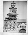
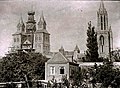
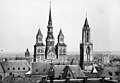
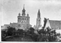
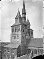
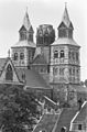
Nederlands: In september 1955 werd de middentoren van de Sint Servaasbasiliek van architect Cuypers door brand verwoest
Media in category "Central westwork tower of Sint-Servaasbasiliek"
The following 33 files are in this category, out of 33 total.
-
 Deel van de kerk vanuit het zuidoosten gezien - Maastricht - 20145563 - RCE.jpg 879 × 1,200; 225 KB
-
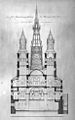 Doorsnede - Maastricht - 20145547 - RCE.jpg 609 × 974; 235 KB
-
 Exterieur OVERZICHT TORENS - Maastricht - 20265879 - RCE.jpg 1,146 × 744; 274 KB
-
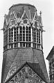 Gedeelte onbekroonde toren - Maastricht - 20146338 - RCE.jpg 778 × 1,200; 224 KB
-

-
 Kerk vanuit het noord-westen - Maastricht - 20145635 - RCE.jpg 887 × 1,200; 140 KB
-

-
 Maastricht, klokkenluiders Grameer, 1965.jpg 440 × 596; 104 KB
-
 Maastricht, klokkenluiders Grameer, 1970.jpg 598 × 535; 138 KB
-

-
 Noord helft west front - Maastricht - 20145692 - RCE.jpg 874 × 1,200; 253 KB
-
-

-

-
 Sint Servaaskerk - Maastricht - 20146207 - RCE-cropped.jpg 735 × 754; 208 KB
-
 Sint Servaaskerk - Maastricht - 20146207 - RCE.jpg 1,113 × 827; 320 KB
-
-

-
 St-Servaaskerk, tekening westwerk.jpg 877 × 1,080; 425 KB
-
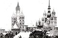
 Torens van Sint-Servaaskerk en Sint-Janskerk - Maastricht - 20410047 - RCE.jpg 1,186 × 819; 275 KB
-

-
-
 Voorbouw vanuit het zuid-oosten - Maastricht - 20145695 - RCE.jpg 883 × 1,200; 222 KB
-
 Voormalige Westtorens - Maastricht - 20146032 - RCE.jpg 801 × 1,200; 180 KB
-
 West bouw naar het noord-oosten - Maastricht - 20145691 - RCE.jpg 924 × 1,200; 249 KB
-
 West bouw vanuit het zuid-oosten - Maastricht - 20145612 - RCE.jpg 897 × 1,200; 215 KB
-
 Westbouw - Maastricht - 20146293 - RCE.jpg 788 × 1,200; 217 KB
-

-
 Westbouw noord-oost gevel - Maastricht - 20146291 - RCE.jpg 788 × 1,200; 231 KB
-

-

-
 Zuidoostzijde van de Sint-Servaasbasiliek te Maastricht, RP-F-00-5148.jpg 6,124 × 4,480; 2.2 MB
-
 Zuidoostzijde van de Sint-Servaasbasiliek te Maastricht, RP-F-00-5149.jpg 6,152 × 4,464; 1.97 MB


.jpg)


.jpg)


