Category:Catharinastraat 7, Breda
Jump to navigation
Jump to search
| Object location | | View all coordinates using: OpenStreetMap |
|---|
 | |||||
| Upload media | |||||
| Instance of |
| ||||
|---|---|---|---|---|---|
| Location | Breda, North Brabant, Netherlands | ||||
| Street address |
| ||||
| Located on street | |||||
| Heritage designation |
| ||||
 | |||||
|
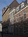
This is a category about rijksmonument number 10113
|
| Address |
|
Media in category "Catharinastraat 7, Breda"
The following 3 files are in this category, out of 3 total.
-
 Breda Catharinastraat7.jpg 2,736 × 3,648; 5.48 MB
-
 Exterieur, 9 - Breda - 20040920 - RCE.jpg 954 × 1,200; 292 KB
-
 Overzicht van de voorgevel met ingangspartij - Breda - 20040915 - RCE.jpg 889 × 1,200; 270 KB

