Category:Carte ou plan nouveau du lac Ontario
Jump to navigation
Jump to search
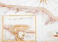
Français : CARTE, ou plan Nouveau du Lac Ontario, avec touttes les isles et bayes qui y Sont rénfermées; : Et les forts qui Sont Scitués Sur les bords du dit Lac
English: Author: Laforce, René-Hippolyte
Date: 1757
Location: Fort Frontenac (Ont. : Fort), Fort Ontario (N.Y.), Fort Oswego (Oswego, N.Y.), Old Fort Niagara (N.Y.), Ontario, Lake (N.Y. and Ont.)
Dimensions: 39 x 71 cm
Scale: approximately 1:1,030,000
Reference: Titled 'Carte ou plan nouveau du lac Ontario ... par Hypolitte laforce le 4e fevrier 1757'. 1:1029000 approx. 'Echelle de 20 lieues maerines' (= 108 mm.). French. Amherst no. A 66. R.U.S.I. no. A 27.32. 390 x 705 mm in The British Library catalogue of additions to the manuscripts, new series 1971-1975.
Media in category "Carte ou plan nouveau du lac Ontario"
The following 5 files are in this category, out of 5 total.
-
 Carte ou plan nouveau du lac Ontario - Chouayguin.jpg 1,998 × 2,015; 1,016 KB
-
 Carte ou plan nouveau du lac Ontario - Fort de Niagara.jpg 2,647 × 1,928; 1.23 MB
-
 Carte ou plan nouveau du lac Ontario - Fort de Toronto.jpg 2,254 × 2,414; 1.37 MB
-
 Carte ou plan nouveau du lac Ontario - Fort Frontenac.jpg 2,734 × 2,446; 1.87 MB
-
 Carte ou plan nouveau du lac Ontario.jpg 8,532 × 4,715; 10.51 MB


