Category:Carmanah Point light
Jump to navigation
Jump to search
| Object location | | View all coordinates using: OpenStreetMap |
|---|
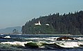
English: Carmanah Point Light Station
lighthouse on Vancouver Island in British Columbia, Canada  | |||||
| Upload media | |||||
| Instance of | |||||
|---|---|---|---|---|---|
| Made from material | |||||
| Located in protected area | |||||
| Location | Cowichan Valley Regional District, British Columbia, Canada | ||||
| Located in or next to body of water | |||||
| Heritage designation | |||||
| Service entry |
| ||||
| Inception |
| ||||
| Height |
| ||||
 | |||||
Media in category "Carmanah Point light"
The following 4 files are in this category, out of 4 total.
-
 Carmanah Lighthouse (10566711234).jpg 1,256 × 771; 417 KB
-
 Carmanah Lighthouse.jpeg 338 × 450; 98 KB
-
 Carmanah Point Lighthouse - BC Canada.jpg 1,024 × 1,544; 459 KB
-
 Vancouver Island lighthouse.jpg 962 × 1,499; 712 KB
.jpg)


Categories:
- Lighthouses in Canada by name
- Lighthouses in British Columbia
- Pacific Rim National Park
- Buildings on Vancouver Island
- Carmanah Walbran Provincial Park
- Concrete lighthouses in Canada
- Lighthouses built in 1920
- Lighthouses by height, 11 to 20 meters
- Lighthouses of the Pacific Ocean
- Lighthouses by range, 20 to 24 nm
- Landfall lights