Category:Cape Alava
Jump to navigation
Jump to search
cape  | |||||
| Upload media | |||||
| Instance of | |||||
|---|---|---|---|---|---|
| Located in protected area | |||||
| Location | Clallam County, Washington, Pacific Northwest, Washington, Pacific States Region | ||||
| Located in or next to body of water | |||||
 | |||||
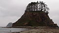
English: Cape Alava – westernmost point in the contiguous United States
Media in category "Cape Alava"
The following 14 files are in this category, out of 14 total.
-
 Alava in fog.jpg 928 × 512; 190 KB
-
 Cape Alava (7857550328).jpg 5,611 × 4,316; 12.86 MB
-
 Cape Alava - Flickr - GregTheBusker.jpg 2,048 × 294; 105 KB
-
 Cape Alava Ozette Island.jpg 1,200 × 800; 390 KB
-
 Cape Alava, Ozette Island.jpg 1,122 × 696; 577 KB
-
 CapeAlaveDaytime.JPG 2,944 × 1,656; 846 KB
-
 Gulls (7988543711).jpg 2,129 × 900; 1.38 MB
-
 NPS olympic-cape-alava-camping-map.jpg 977 × 1,265; 117 KB
-
 Ozette Island from Cape Alava.jpg 16,420 × 1,556; 3.34 MB
-
 OzetteIslandDaytime1.JPG 2,944 × 1,656; 741 KB
-
 OzetteIslandSunset.JPG 2,944 × 1,656; 701 KB
-
 Point of Arches from the South.jpg 7,360 × 4,912; 22.69 MB
-
 The western terminus of the PNT at Cape Alava in Olympic National Park (27331385534).jpg 2,048 × 1,456; 230 KB
-
 Tskawahyah Island.jpg 1,599 × 1,066; 246 KB
.jpg)


.jpg)


.jpg)
