Category:Can Pau (Sant Jaume dels Domenys)
Jump to navigation
Jump to search
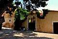
This is a category about a building indexed in the Catalan heritage register as Bé Cultural d'Interès Local (BCIL) under the reference IPA-5429. |
| Object location | | View all coordinates using: OpenStreetMap |
|---|
masia in Sant Jaume dels Domenys (Baix Penedès, Catalonia) _-_1.jpg) | |||||
| Upload media | |||||
| Instance of | |||||
|---|---|---|---|---|---|
| Location | Sant Jaume dels Domenys, Baix Penedès, Tarragona Province, Catalonia | ||||
| Architectural style | |||||
| Heritage designation |
| ||||
 | |||||
Media in category "Can Pau (Sant Jaume dels Domenys)"
The following 3 files are in this category, out of 3 total.
-
 Can Pau (Sant Jaume dels Domenys) - 1.jpg 4,608 × 3,072; 6.4 MB
-
 Can Pau (Sant Jaume dels Domenys) - 2.jpg 4,608 × 3,072; 6.32 MB
-
 Masia Can Pau, Sant Jaume dels Domenys.jpg 3,132 × 3,072; 4.24 MB
_-_2.jpg)
