Category:California State Route 185
Jump to navigation
Jump to search
highway in California   | |||||
| Upload media | |||||
| Instance of | |||||
|---|---|---|---|---|---|
| Location | Alameda County, California, Pacific States Region | ||||
| Transport network |
| ||||
| Owned by | |||||
| Maintained by | |||||
| Inception |
| ||||
| Length |
| ||||
| Terminus | |||||
 | |||||
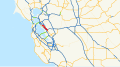
- California State Route 185 — in the East San Francisco Bay Area.
- It runs along sections of Mission Boulevard in Hayward, East 14th Street in San Leandro, and International Boulevard in Oakland.
Subcategories
This category has the following 2 subcategories, out of 2 total.
C
- California State Route 77 (4 F)
T
Media in category "California State Route 185"
The following 10 files are in this category, out of 10 total.
-
 Ashland California close up.jpg 3,276 × 1,664; 2.36 MB
-
 Ashland California extra close.jpg 2,057 × 986; 947 KB
-
 Ashland California wide view.jpg 4,592 × 1,599; 3.91 MB
-
 California 185.svg 449 × 401; 14 KB
-
 California State Route 185 Map.svg 1,028 × 609; 6.18 MB
-
 California State Route 185.svg 1,152 × 640; 394 KB
-
 California State Routes 185 and 77.svg 1,152 × 640; 396 KB
-
 CherrylandCropped1.jpg 4,592 × 1,570; 2.48 MB
-
 CherrylandCropped2.jpg 4,592 × 1,075; 1.98 MB
-
 CherrylandCropped3.jpg 4,592 × 360; 807 KB


