Category:CIA maps of Iran
Jump to navigation
Jump to search
Subcategories
This category has the following 2 subcategories, out of 2 total.
C
- CIA World Factbook maps of Iran (23 F)
Media in category "CIA maps of Iran"
The following 33 files are in this category, out of 33 total.
-
 2009 CIA Iran country profile.png 15,561 × 10,184; 263.48 MB
-
 2009 Iran and eastern United States size comparison by the CIA.png 1,000 × 1,000; 1.73 MB
-
 2009 Iran key petroleum sector facilities by the CIA (map key).png 596 × 701; 600 KB
-
 2009 Iran key petroleum sector facilities by the CIA.png 2,636 × 2,635; 11.59 MB
-
 2009 Iran location map by the CIA.png 1,275 × 1,235; 2.63 MB
-
 2009 Iran population density by the CIA (map key).png 474 × 545; 394 KB
-
 2009 Iran regional physiography by the CIA.png 2,788 × 1,829; 7.93 MB
-
-
 2009 Iran southern Caspian energy prospects by the CIA (map key).png 794 × 483; 573 KB
-
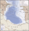 2009 Iran southern Caspian energy prospects by the CIA.png 2,640 × 2,842; 13.05 MB
-
 2009 Iran Strait of Hormuz by the CIA (map key – bathymetry).png 470 × 816; 584 KB
-
 2009 Iran Strait of Hormuz by the CIA.png 2,640 × 2,842; 12.81 MB
-
 British Agencies in Iran - DPLA - 99de26f85dbaae473fc632e5a30e7304.jpg 4,712 × 4,770; 2.52 MB
-
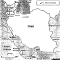
 CIA assessment of USSR activity in Iran, 1947 (marked map).jpg 5,800 × 5,830; 3.43 MB
-
 CIA map, The Persian Telephone System, undated.pdf 1,275 × 1,650, 4 pages; 9.81 MB
-
 CIA, Map of Major Iranian Dissident Combat Operations.jpg 1,481 × 1,467; 110 KB
-
 Full-Scale Invasion of Iran.png 727 × 721; 103 KB
-
 Invasion of the Persian Gulf Littorial.png 728 × 724; 86 KB
-
 Iran - DPLA - 0b841f02f6809e208ed95f9d46a02222.jpg 10,076 × 8,829; 5.33 MB
-
 Iran - DPLA - 24aad0c2ad0a4eeda6d423a478165e67.jpg 10,056 × 8,852; 7.62 MB
-
 Iran - DPLA - c525e01bf83f4fc6691d1785768a4bdc.jpg 3,669 × 4,556; 1.63 MB
-
 Iran - DPLA - d110b980639f712706fd13b89ca2c07b.jpg 10,240 × 8,820; 6.6 MB
-
 Iran - DPLA - da3570e3660038bc2437ff34e67b1fe8.jpg 10,217 × 8,833; 5.84 MB
-
 Iran - DPLA - ec01d9fe40b8c44c44d9eefed9e97ae6 (page 1).jpg 10,026 × 8,813; 8.05 MB
-
 Iran - DPLA - ec01d9fe40b8c44c44d9eefed9e97ae6 (page 2).jpg 10,021 × 8,897; 8.77 MB
-
 Iran - DPLA - f1660b296d1d04124c8ff5bea9a6cb6b.jpg 3,967 × 5,375; 2.42 MB
-
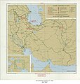
 Iran Current Situation October 1949 - DPLA - f05791ef508bf6c3e214d003a5738895.jpg 3,543 × 3,308; 1.68 MB
-
 Jordan - DPLA - f506356ad26e22be1901b94262db8bdd (page 1).jpg 10,066 × 8,836; 9.1 MB
-
 Limited Invasion to Seize The Port of Bandar Beheshti in Baluchistan.png 726 × 732; 149 KB
-
 Limited Invasion to Seize Āžarbāyjān.png 732 × 732; 146 KB
-

-
 Soviet Agencies In Iran - DPLA - 75a8bc61c98e9fb3b2feb94dbddfd026.jpg 5,784 × 6,111; 3.98 MB
-


.png)


.png)

.png)
.png)

.png)


.jpg)


.jpg)
.jpg)


.jpg)


