Category:Câmara Municipal de Soure
Jump to navigation
Jump to search
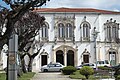
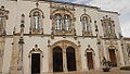
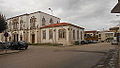
| This building is classified as Sem proteção legal .It is indexed in the SIPA database (Sistema de Informação para o Património Arquitetónico) under the reference 23468. |
| Object location | | View all coordinates using: OpenStreetMap |
|---|
 | |||||
| Upload media | |||||
| Instance of | |||||
|---|---|---|---|---|---|
| Location | Soure, Coimbra, Portugal | ||||
| Heritage designation | |||||
 | |||||
Media in category "Câmara Municipal de Soure"
The following 19 files are in this category, out of 19 total.
-
 Câmara Municipal de Soure - Portugal (53495587386).jpg 1,365 × 2,048; 2.02 MB
-
 Câmara Municipal, Soure 01.jpg 4,608 × 2,592; 2.46 MB
-
 Câmara Municipal, Soure 02.jpg 4,608 × 2,592; 2.72 MB
-
 Pacos do Concelho de Soure.jpg 1,280 × 959; 435 KB
-
 Paços do Concelho de Soure - Portugal (154777479).jpg 1,280 × 960; 246 KB
-
 Soure Câmara Municipal 328.jpg 4,730 × 3,153; 9.15 MB
-
 Soure Câmara Municipal 329.jpg 4,850 × 3,233; 10.58 MB
-
 Soure Câmara Municipal 330.jpg 4,896 × 3,264; 13.14 MB
-
 Soure DSC 0879 (53648889570).jpg 3,696 × 2,448; 2.57 MB
-
 Soure DSC 0880 (53648868848).jpg 3,696 × 2,448; 2.74 MB
-
 SoureCâmaraMunicipal 01.JPG 4,608 × 2,592; 2.58 MB
-
 SoureCâmaraMunicipal 02.JPG 4,608 × 2,592; 2.69 MB
-
 SoureCâmaraMunicipal 03.JPG 4,608 × 2,592; 2.5 MB
-
 SoureCâmaraMunicipal 04.JPG 4,608 × 2,592; 2.67 MB
-
 SoureCâmaraMunicipal 05.JPG 4,608 × 2,592; 2.52 MB
-
 SoureCâmaraMunicipal 06.JPG 4,608 × 2,592; 2.51 MB
-
 SoureCâmaraMunicipal 07.JPG 4,608 × 2,592; 2.56 MB
-
 SoureCâmaraMunicipal 08.JPG 4,608 × 2,592; 2.62 MB
-
 SoureCâmaraMunicipal 09.JPG 4,608 × 2,592; 2.57 MB
.jpg)


.jpg)


.jpg)
.jpg)


