Category:Butterwick, Lincolnshire
Jump to navigation
Jump to search
English: Butterwick is a village in Lincolnshire, England, about 3 miles north-east of Boston town centre.
village and civil parish in the Borough of Boston, Lincolnshire, England  | |||||
| Upload media | |||||
| Instance of | |||||
|---|---|---|---|---|---|
| Location | Boston, Lincolnshire, East Midlands, England | ||||
| Population |
| ||||
 | |||||
Subcategories
This category has the following 4 subcategories, out of 4 total.
A
P
S
Media in category "Butterwick, Lincolnshire"
The following 93 files are in this category, out of 93 total.
-
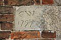 18th century graffiti - geograph.org.uk - 1550148.jpg 640 × 426; 108 KB
-
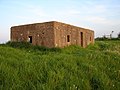
 3-bay Pill Box near Butterwick - geograph.org.uk - 558666.jpg 640 × 480; 94 KB
-
 A couple geocashing - geograph.org.uk - 4358608.jpg 640 × 480; 64 KB
-
 A very short road - geograph.org.uk - 3718569.jpg 1,600 × 1,200; 768 KB
-

-

-

-
 Benington, aerial 2017 - geograph.org.uk - 5392894.jpg 800 × 534; 62 KB
-

-
 Butterwick Common - geograph.org.uk - 181590.jpg 640 × 427; 97 KB
-

-
 Butterwick old Roman sea bank - geograph.org.uk - 1133665.jpg 640 × 480; 151 KB
-
 Butterwick old school - geograph.org.uk - 1236772.jpg 640 × 426; 62 KB
-
 Butterwick Village Hall - geograph.org.uk - 4437521.jpg 640 × 427; 57 KB
-
 Butterwick, aerial 2016 - geograph.org.uk - 5012960.jpg 640 × 427; 44 KB
-
 Cabbage field - geograph.org.uk - 3897443.jpg 640 × 480; 116 KB
-

-
 Close to The Wash - geograph.org.uk - 5134654.jpg 4,608 × 3,456; 2.32 MB
-

-
 Creek formation on mudflat - geograph.org.uk - 389098.jpg 640 × 480; 69 KB
-
 Cross the A52 towards Butterwick - geograph.org.uk - 4437510.jpg 640 × 427; 77 KB
-
 Derelict farm buildings - geograph.org.uk - 405320.jpg 640 × 427; 57 KB
-
 Disused mill - geograph.org.uk - 6342651.jpg 640 × 480; 69 KB
-
 Double Bank facing south - geograph.org.uk - 2789885.jpg 1,280 × 853; 383 KB
-

-

-
 Drainage channel and sea bank at Butterwick Low - geograph.org.uk - 2648262.jpg 3,072 × 2,304; 2.51 MB
-
 Edge of Butterwick - geograph.org.uk - 4171673.jpg 1,600 × 1,200; 535 KB
-
 Edge of Butterwick - geograph.org.uk - 4171674.jpg 1,600 × 1,200; 602 KB
-
 Electricity Pylons near High Ferry - geograph.org.uk - 2790537.jpg 1,280 × 853; 217 KB
-
 Entrance to Butterwick - geograph.org.uk - 4138896.jpg 640 × 480; 56 KB
-

-
 Farmland behind the sea bank - geograph.org.uk - 3704253.jpg 1,600 × 1,566; 778 KB
-
 Farmland east of Hobbhole Bank - geograph.org.uk - 3897452.jpg 640 × 480; 62 KB
-
 Farmland off Hobbhole Bank - geograph.org.uk - 3897451.jpg 640 × 480; 53 KB
-
 Farmland south of Butterwick, aerial 2016 - geograph.org.uk - 5012982.jpg 1,024 × 683; 102 KB
-
 Fendyke End Lane - geograph.org.uk - 2789893.jpg 1,280 × 853; 253 KB
-
 Flat lands - geograph.org.uk - 4358595.jpg 640 × 465; 57 KB
-

-
 Gate leading to the sea bank - geograph.org.uk - 3718668.jpg 1,600 × 1,133; 553 KB
-
 Grassland between the sea banks - geograph.org.uk - 3684030.jpg 640 × 427; 40 KB
-
 Green side of the old sea wall - geograph.org.uk - 3683972.jpg 640 × 427; 60 KB
-
 Harvesting Brussels Sprouts - geograph.org.uk - 2789890.jpg 640 × 427; 82 KB
-
 Heading north along the sea bank - geograph.org.uk - 3704256.jpg 1,600 × 1,194; 533 KB
-
 High Tide - geograph.org.uk - 797791.jpg 640 × 480; 36 KB
-
 Hobbhole Bank - geograph.org.uk - 3897444.jpg 640 × 480; 57 KB
-
 Hobbhole Bank - geograph.org.uk - 3897449.jpg 640 × 480; 61 KB
-
 Hobbhole Drain - geograph.org.uk - 3897446.jpg 640 × 480; 84 KB
-
 Ings Drove towards Ivy House farm - geograph.org.uk - 2790533.jpg 1,280 × 853; 284 KB
-
 Interesting features ahead - geograph.org.uk - 5134633.jpg 4,608 × 3,456; 2.57 MB
-
 Ireland Farm from Hob Hole Bank - geograph.org.uk - 2788878.jpg 1,280 × 853; 406 KB
-
 Jail Lane - geograph.org.uk - 498121.jpg 640 × 427; 62 KB
-
 Jail Lane and Sea Lane - geograph.org.uk - 1933747.jpg 640 × 480; 74 KB
-
 Jail Lane, Freiston Shore - geograph.org.uk - 5573036.jpg 640 × 427; 68 KB
-
 Lowfields Lane and Hobhole Farm - geograph.org.uk - 2789882.jpg 1,280 × 853; 271 KB
-
 Lunch break - geograph.org.uk - 5134567.jpg 4,608 × 3,456; 3.06 MB
-
 Mill Lane - geograph.org.uk - 6342647.jpg 640 × 480; 59 KB
-
 Old Milepost - geograph.org.uk - 2731846.jpg 768 × 1,024; 399 KB
-
 One field closer to the edge. - geograph.org.uk - 3683987.jpg 640 × 427; 57 KB
-
 Ordnance Survey benchmark - geograph.org.uk - 4138901.jpg 640 × 480; 115 KB
-
 Pill Box Near Sea Bank - geograph.org.uk - 797761.jpg 640 × 480; 87 KB
-
 Pillbox on sea bank - geograph.org.uk - 4358605.jpg 640 × 480; 54 KB
-
 Pillbox on the sea bank - geograph.org.uk - 3718671.jpg 1,600 × 1,068; 477 KB
-
 Pinchbeck's School - geograph.org.uk - 1236714.jpg 640 × 426; 70 KB
-
 Pinchbeck's School - geograph.org.uk - 1236719.jpg 640 × 426; 70 KB
-
 Potato crop along Sea Lane - geograph.org.uk - 3718610.jpg 1,600 × 1,137; 545 KB
-
 Rivulets in the sand - geograph.org.uk - 5134642.jpg 4,608 × 3,456; 2.3 MB
-
 Road to car park - geograph.org.uk - 4358599.jpg 640 × 480; 67 KB
-
 Scout Hut - geograph.org.uk - 1236778.jpg 640 × 426; 76 KB
-
 Sea bank - geograph.org.uk - 4358631.jpg 640 × 480; 55 KB
-
 Sea Lane, Butterwick - geograph.org.uk - 5573029.jpg 640 × 427; 87 KB
-

-
 Sea marshes - geograph.org.uk - 4358623.jpg 640 × 480; 56 KB
-
 Shells on the seashore - geograph.org.uk - 5134670.jpg 4,608 × 3,456; 4.67 MB
-
 Small car park at the end of Sea Lane - geograph.org.uk - 3718627.jpg 1,600 × 1,078; 524 KB
-

-
 Sunset Moo - geograph.org.uk - 797753.jpg 640 × 480; 32 KB
-
 The Five Bells - geograph.org.uk - 4358647.jpg 640 × 480; 89 KB
-

-

-
 Three in a Row - geograph.org.uk - 797720.jpg 640 × 480; 61 KB
-
 Tide's out - geograph.org.uk - 1521612.jpg 640 × 480; 53 KB
-
 Track to the sea banks - geograph.org.uk - 3682701.jpg 640 × 427; 90 KB
-
 Unusual object - geograph.org.uk - 5134665.jpg 4,608 × 3,456; 3.98 MB
-
 Wainfleet 14 - geograph.org.uk - 2731844.jpg 1,024 × 768; 305 KB
-
 Watery Lane towards Butterwick - geograph.org.uk - 3718590.jpg 1,600 × 1,171; 507 KB
-
 Watery Lane, Butterwick Sea End - geograph.org.uk - 3682718.jpg 640 × 427; 95 KB
-
 West Common South Drain - geograph.org.uk - 457991.jpg 640 × 427; 95 KB
-
 Westering Home - geograph.org.uk - 797783.jpg 640 × 480; 39 KB
-
 Wooden pallet on the sea bank - geograph.org.uk - 3704260.jpg 1,600 × 1,184; 506 KB
-
 Freiston farmland - geograph.org.uk - 405225.jpg 640 × 427; 59 KB
-
 Hob Hole Drain - geograph.org.uk - 147457.jpg 640 × 427; 73 KB
-
 Oak Lodge - geograph.org.uk - 405261.jpg 640 × 427; 77 KB


_-_geograph.org.uk_-_4962286.jpg)


_-_geograph.org.uk_-_4962275.jpg)


