Category:Burpham
Jump to navigation
Jump to search
English: Burpham is a village and civil parish in the Arun District of West Sussex, England. The village is located two miles (3.2km) north from Arundel, on an arm of the River Arun. Burpham parish church of St Mary is of Saxon origin. The civil parish includes the hamlet of Wepham, which is almost conjoined to Burpham village.

village in United Kingdom  | |||||
| Upload media | |||||
| Instance of | |||||
|---|---|---|---|---|---|
| Location | Arun, West Sussex, South East England, England | ||||
| Area |
| ||||
| Different from | |||||
| Said to be the same as | Burpham (Wikimedia duplicated page, civil parish) | ||||
 | |||||
Subcategories
This category has the following 3 subcategories, out of 3 total.
Media in category "Burpham"
The following 200 files are in this category, out of 675 total.
(previous page) (next page)-
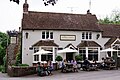 'The George', Burpham - geograph.org.uk - 5805920.jpg 3,720 × 2,480; 7.68 MB
-

-
 102-103 The Splash, Wepham - geograph.org.uk - 3581274.jpg 640 × 480; 108 KB
-
 104, The Splash, Wepham - geograph.org.uk - 3581280.jpg 640 × 480; 103 KB
-
 105, Burpham Road, Wepham - geograph.org.uk - 3618671.jpg 640 × 480; 82 KB
-
 72-73, Peppering High Barn - geograph.org.uk - 3586090.jpg 640 × 480; 76 KB
-
 74-75, Peppering High Barn - geograph.org.uk - 3620294.jpg 640 × 480; 93 KB
-
 82-83, The Street, Burpham - geograph.org.uk - 3581219.jpg 480 × 640; 133 KB
-
 84, The Street, Burpham - geograph.org.uk - 3625754.jpg 640 × 480; 109 KB
-
 87, The Street, Burpham - geograph.org.uk - 3592039.jpg 640 × 480; 59 KB
-
 88-89, The Street, Burpham - geograph.org.uk - 3602807.jpg 640 × 480; 92 KB
-
 95-96 Wepham Green, Wepham - geograph.org.uk - 3590611.jpg 640 × 474; 100 KB
-
 A foggy day on the Downs (1) - geograph.org.uk - 2710486.jpg 1,024 × 768; 101 KB
-
 A foggy day on the Downs (2) - geograph.org.uk - 2713779.jpg 1,024 × 768; 92 KB
-
 A foggy day on the Downs (3) - geograph.org.uk - 2713808.jpg 1,024 × 768; 115 KB
-
 A lingering chicory flower - geograph.org.uk - 4689327.jpg 758 × 1,024; 177 KB
-
-
 Abandoned Boat, The Outer Hail - geograph.org.uk - 3612461.jpg 640 × 480; 84 KB
-
 Access road to Burpham High Barn, West Sussex - geograph.org.uk - 2747663.jpg 755 × 1,024; 170 KB
-
 After the harvest - geograph.org.uk - 3123372.jpg 1,024 × 788; 249 KB
-
 Agricultural machinery, Home Farm - geograph.org.uk - 1889540.jpg 640 × 428; 109 KB
-
 Along the Bridleway - geograph.org.uk - 5805847.jpg 3,300 × 2,200; 7.64 MB
-
 Along the Bridleway - geograph.org.uk - 5805850.jpg 3,240 × 2,160; 7.57 MB
-
 Angmering Park Cottages - geograph.org.uk - 5707865.jpg 640 × 428; 155 KB
-

-
 Approaching St Mary's Church - geograph.org.uk - 3676478.jpg 4,000 × 3,000; 4.52 MB
-
 Approaching The Conyers from the south - geograph.org.uk - 2724597.jpg 1,024 × 768; 186 KB
-
 Arun Valley - geograph.org.uk - 3618643.jpg 640 × 480; 64 KB
-
 Arun Valley Railway - geograph.org.uk - 3612439.jpg 640 × 480; 86 KB
-
 Arun Valley Railway - geograph.org.uk - 3618922.jpg 640 × 480; 59 KB
-
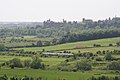
 Arundel Castle - geograph.org.uk - 3612331.jpg 640 × 480; 41 KB
-
 Arundel Castle from Burpham - geograph.org.uk - 4865133.jpg 1,333 × 1,000; 938 KB
-
 Backwoods, The Splash, Wepham - geograph.org.uk - 3618749.jpg 640 × 480; 92 KB
-
 Bare Shins - geograph.org.uk - 3614450.jpg 640 × 480; 70 KB
-
 Barn at Peppering Farm - geograph.org.uk - 5805868.jpg 3,600 × 2,400; 7.76 MB
-
 Barn at Peppering Farm - geograph.org.uk - 5805876.jpg 3,600 × 2,400; 7.62 MB
-
 Barn, Peppering Farm - geograph.org.uk - 3594485.jpg 640 × 489; 66 KB
-
 Barns, Home Farm - geograph.org.uk - 3614440.jpg 640 × 480; 104 KB
-
 Barns, Peppering Farm - geograph.org.uk - 3618893.jpg 640 × 480; 65 KB
-

-
 Bend in the River Arun near Foxes Oven - geograph.org.uk - 2523909.jpg 1,024 × 768; 236 KB
-
 Birds of Prey above The Burgh - geograph.org.uk - 3620213.jpg 572 × 640; 61 KB
-
 Black Rabbit Pub, Arundel - geograph.org.uk - 4572080.jpg 1,600 × 1,200; 400 KB
-
 Blackstone's Mead (1) - geograph.org.uk - 3612430.jpg 640 × 480; 82 KB
-
 Blackstone's Mead (2) - geograph.org.uk - 3617105.jpg 640 × 480; 76 KB
-
 Bluebells at Angmering estate - geograph.org.uk - 1277660.jpg 640 × 426; 130 KB
-
 Boundary Brook - geograph.org.uk - 3605629.jpg 480 × 640; 136 KB
-
 Boundary Brook - geograph.org.uk - 3612380.jpg 480 × 640; 85 KB
-
 Boundary Brook - geograph.org.uk - 3614548.jpg 640 × 480; 103 KB
-
 Boundary Mead - geograph.org.uk - 3612367.jpg 640 × 480; 65 KB
-
 Boundary Slipe - geograph.org.uk - 3612400.jpg 640 × 480; 72 KB
-
 Bridge, Arun Valley Railway - geograph.org.uk - 3586266.jpg 640 × 480; 74 KB
-
 Bridleway 2212 - geograph.org.uk - 4215443.jpg 640 × 428; 265 KB
-
 Bridleway 2221 - geograph.org.uk - 4215592.jpg 640 × 428; 269 KB
-
 Bridleway 2279 to North Stoke - geograph.org.uk - 3644789.jpg 4,000 × 3,000; 5.36 MB
-
 Bridleway changes direction - geograph.org.uk - 3647002.jpg 4,000 × 3,000; 5.55 MB
-
 Bridleway crosses Angmering Estate track - geograph.org.uk - 2724540.jpg 1,024 × 768; 240 KB
-
 Bridleway goes through woodland on Barpham Hill - geograph.org.uk - 2724084.jpg 1,024 × 768; 279 KB
-
 Bridleway in Tenantry Copse (1) - geograph.org.uk - 2724557.jpg 600 × 800; 240 KB
-
 Bridleway in Tenantry Copse (2) - geograph.org.uk - 2724559.jpg 1,024 × 768; 369 KB
-
 Bridleway junction at The Burgh - geograph.org.uk - 2486081.jpg 800 × 600; 119 KB
-
 Bridleway junction by Wepham Woods - geograph.org.uk - 4215449.jpg 640 × 428; 256 KB
-
 Bridleway junction by Wepham Woods - geograph.org.uk - 4215457.jpg 640 × 428; 205 KB
-

-

-
 Bridleway on Wepham Down - geograph.org.uk - 5348729.jpg 4,608 × 3,456; 6.55 MB
-
 Bridleway to Angmering Park - geograph.org.uk - 3581321.jpg 640 × 480; 130 KB
-
 Bridleway to Burpham - geograph.org.uk - 3602838.jpg 480 × 640; 77 KB
-
 Bridleway to Burpham High Barn - geograph.org.uk - 2722215.jpg 1,024 × 768; 228 KB
-
 Bridleway to Burpham High Barn - geograph.org.uk - 3590367.jpg 480 × 640; 82 KB
-
 Bridleway to Lee Farm - geograph.org.uk - 2722061.jpg 1,024 × 768; 132 KB
-
 Bridleway to Wepham - geograph.org.uk - 3603618.jpg 640 × 480; 82 KB
-
 Bridleway to Wepham - geograph.org.uk - 3603641.jpg 480 × 640; 138 KB
-
 Bridleway to Wepham Down - geograph.org.uk - 1329575.jpg 640 × 480; 87 KB
-
 Bridleway to Wepham Down - geograph.org.uk - 2724566.jpg 768 × 1,024; 373 KB
-
 Bridleway to Wepham Down - geograph.org.uk - 3603040.jpg 640 × 480; 68 KB
-
 Bridleway towards Wepham Down - geograph.org.uk - 4689348.jpg 1,024 × 768; 202 KB
-
 Bridleway with a view - geograph.org.uk - 2486118.jpg 1,024 × 768; 158 KB
-
 Bridleway, The Conyers - geograph.org.uk - 3605280.jpg 640 × 480; 131 KB
-
 Bridleway, Wepham Down - geograph.org.uk - 3585050.jpg 640 × 480; 86 KB
-
 Bridleway, Wepham Down - geograph.org.uk - 3602928.jpg 640 × 480; 88 KB
-
 Broadwalls - geograph.org.uk - 3612432.jpg 640 × 480; 73 KB
-
 Brook Lea, The Splash, Burpham - geograph.org.uk - 3614574.jpg 640 × 480; 116 KB
-
 Buildings at Home Farm - geograph.org.uk - 4215704.jpg 640 × 428; 132 KB
-
 Burgh House, The Splash, Burpham - geograph.org.uk - 3614584.jpg 640 × 480; 94 KB
-
 Burpham - geograph.org.uk - 3614480.jpg 640 × 302; 67 KB
-
 Burpham - geograph.org.uk - 5805915.jpg 3,900 × 2,600; 7.68 MB
-
 Burpham - geograph.org.uk - 5805930.jpg 3,900 × 2,600; 7.64 MB
-
 Burpham - geograph.org.uk - 5805932.jpg 3,660 × 2,440; 7.69 MB
-
 Burpham - geograph.org.uk - 5805942.jpg 3,480 × 2,320; 7.66 MB
-
 Burpham - geograph.org.uk - 5805948.jpg 3,780 × 2,520; 7.78 MB
-
 Burpham - geograph.org.uk - 5805953.jpg 3,720 × 2,480; 7.73 MB
-
 Burpham - geograph.org.uk - 5805959.jpg 3,420 × 2,280; 7.74 MB
-
 Burpham - Large Victorian House - geograph.org.uk - 5345685.jpg 4,608 × 3,456; 7.02 MB
-
 Burpham - Small Stream Leading to the River Arun - geograph.org.uk - 5345730.jpg 4,608 × 3,456; 6.11 MB
-
 Burpham Brook - geograph.org.uk - 3592072.jpg 640 × 460; 55 KB
-
 Burpham church tower seen from Arun footpath - geograph.org.uk - 2523899.jpg 1,024 × 768; 238 KB
-
 Burpham Country House Hotel - geograph.org.uk - 3602821.jpg 480 × 640; 76 KB
-
 Burpham cricket ground - geograph.org.uk - 1025138.jpg 640 × 480; 171 KB
-
 Burpham Cricket Ground - geograph.org.uk - 3605731.jpg 640 × 480; 71 KB
-
 Burpham Cricket Ground - geograph.org.uk - 3614645.jpg 640 × 480; 57 KB
-
 Burpham Cricket Ground and Pavilion - geograph.org.uk - 4865140.jpg 1,323 × 1,000; 1.09 MB
-
 Burpham Cricket Pavilion - geograph.org.uk - 6152326.jpg 3,536 × 2,303; 2.37 MB
-

-
 Burpham High Barn - geograph.org.uk - 2613761.jpg 1,024 × 761; 138 KB
-
 Burpham High Barn - geograph.org.uk - 2722269.jpg 1,024 × 768; 127 KB
-
 Burpham High Barn - geograph.org.uk - 3590713.jpg 640 × 402; 71 KB
-
 Burpham High Barn - geograph.org.uk - 3602902.jpg 640 × 480; 56 KB
-
 Burpham High Barn - geograph.org.uk - 94945.jpg 640 × 480; 96 KB
-
 Burpham Hill - geograph.org.uk - 2959147.jpg 1,600 × 1,200; 344 KB
-
 Burpham House, The Street, Burpham - geograph.org.uk - 3625776.jpg 640 × 447; 97 KB
-

-

-
 Burpham Loop, River Arun - geograph.org.uk - 3592084.jpg 640 × 480; 115 KB
-
 Burpham Loop, River Arun - geograph.org.uk - 3618905.jpg 640 × 480; 49 KB
-
 Burpham Mead - geograph.org.uk - 3612358.jpg 640 × 480; 54 KB
-
 Burpham Place, The Street, Burpham - geograph.org.uk - 3625741.jpg 640 × 486; 92 KB
-
 Burpham Playground - geograph.org.uk - 3617077.jpg 640 × 480; 73 KB
-
 Burpham Pumping Station - geograph.org.uk - 3591979.jpg 480 × 640; 64 KB
-
 Burpham Road - geograph.org.uk - 3590595.jpg 640 × 480; 91 KB
-
 Burpham Road - geograph.org.uk - 3605322.jpg 640 × 480; 60 KB
-
 Burpham Road - geograph.org.uk - 3614665.jpg 640 × 480; 91 KB
-
 Burpham viewed from Burpham Hill - geograph.org.uk - 2959462.jpg 1,600 × 1,200; 579 KB
-
 Burpham Village Car Park - geograph.org.uk - 3618762.jpg 640 × 480; 108 KB
-
 Burpham Village from Perry Hill - geograph.org.uk - 1277644.jpg 640 × 424; 65 KB
-
 Burpham Village Hall - geograph.org.uk - 3605738.jpg 640 × 480; 74 KB
-
 Burpham, cottage at the junction - geograph.org.uk - 3525545.jpg 640 × 427; 104 KB
-
 Burpham, Peppering Farm - geograph.org.uk - 4819538.jpg 3,872 × 2,592; 4.4 MB
-
 Burpham, Peppering Farm - geograph.org.uk - 4819539.jpg 1,849 × 1,650; 1.55 MB
-
 Burpham, Sussex - geograph.org.uk - 2237549.jpg 4,592 × 2,196; 4.88 MB
-
 Burpham, The track from Peppering Farm - geograph.org.uk - 4819540.jpg 2,592 × 3,872; 4.26 MB
-
 Burpham, The track from Peppering Farm - geograph.org.uk - 4819541.jpg 3,872 × 2,592; 5.64 MB
-
 Burpham- path from the church to the pub - geograph.org.uk - 1897167.jpg 640 × 480; 133 KB
-
 Canoeist, River Arun - geograph.org.uk - 3618959.jpg 640 × 332; 91 KB
-
 Chalk heap at The Burgh - geograph.org.uk - 3525450.jpg 640 × 427; 75 KB
-
 Chalk scree - geograph.org.uk - 393510.jpg 640 × 480; 123 KB
-

-
 Christmas Dinner - geograph.org.uk - 3676453.jpg 4,000 × 3,000; 3.74 MB
-
 Church Cottage, The Street, Burpham - geograph.org.uk - 3612317.jpg 480 × 640; 73 KB
-
 Church Field (2) - geograph.org.uk - 3618755.jpg 640 × 460; 83 KB
-
 Church Field - geograph.org.uk - 3594530.jpg 640 × 480; 54 KB
-
 Church of St Mary Burpham - geograph.org.uk - 2959678.jpg 1,600 × 1,533; 890 KB
-
 Church of St Mary Burpham - geograph.org.uk - 2959686.jpg 1,600 × 1,200; 278 KB
-
 Combe Lane from Perry Hill - geograph.org.uk - 1886305.jpg 640 × 428; 91 KB
-
 Congregation at a signpost - geograph.org.uk - 2722064.jpg 1,024 × 768; 120 KB
-
 Conniers Hill (1) - geograph.org.uk - 3617086.jpg 640 × 480; 72 KB
-
 Conniers Hill (2) - geograph.org.uk - 3618622.jpg 480 × 640; 79 KB
-
 Coombe Cottage - geograph.org.uk - 3591991.jpg 640 × 480; 93 KB
-
 Coombe Lane - geograph.org.uk - 3592010.jpg 480 × 640; 79 KB
-
 Coombe Lane junction at Burpham - geograph.org.uk - 2722218.jpg 1,024 × 768; 229 KB
-
 Coombe Lane looking towards Burpham - geograph.org.uk - 2722259.jpg 768 × 1,024; 307 KB
-
 Coombe Lane passes pumping station - geograph.org.uk - 2722228.jpg 1,024 × 768; 303 KB
-
 Coppice Field-Forty Acres - geograph.org.uk - 3583435.jpg 640 × 480; 47 KB
-
 Copse Croft-The Shortlands - geograph.org.uk - 3602898.jpg 640 × 480; 70 KB
-
 Corner Mead - geograph.org.uk - 3586152.jpg 480 × 640; 55 KB
-
 Cottage on Coombe Lane - geograph.org.uk - 2722221.jpg 1,024 × 768; 246 KB
-
 Cottages near Black Rabbit Pub, Arundel - geograph.org.uk - 4572060.jpg 1,600 × 1,200; 449 KB
-

-
 Council Cottages, Wepham - geograph.org.uk - 3605373.jpg 640 × 480; 75 KB
-
 Court Leet Cottage, Wepham - geograph.org.uk - 3605388.jpg 640 × 480; 98 KB
-
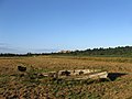
 Cow Grazing, Splash Farm - geograph.org.uk - 2959151.jpg 1,600 × 1,200; 391 KB
-
 Cow Pasture - geograph.org.uk - 3614658.jpg 640 × 480; 88 KB
-
 Cows grazing the water meadows - geograph.org.uk - 3526698.jpg 640 × 427; 101 KB
-
 Cross Dyke, Barpham Hill - geograph.org.uk - 3583433.jpg 640 × 480; 72 KB
-
 Crossing of Paths, New Down - geograph.org.uk - 3603331.jpg 640 × 480; 74 KB
-

-
 Cyclist on Peppering Lane - geograph.org.uk - 3674859.jpg 4,000 × 3,000; 3.55 MB
-
 Ditch, Floodplain of the River Arun - geograph.org.uk - 4760841.jpg 640 × 358; 34 KB
-
 Double gates on Barpham Hill - geograph.org.uk - 2724087.jpg 1,024 × 768; 201 KB
-
 Down steps to Arun Valley - geograph.org.uk - 3647052.jpg 4,000 × 3,000; 4.18 MB
-

-

-
 Downland bridleway at footpath junction - geograph.org.uk - 2489632.jpg 800 × 600; 152 KB
-
 Downland bridleway on a bleak December day - geograph.org.uk - 2722053.jpg 1,024 × 768; 145 KB
-
 Downland field with poppies (1) - geograph.org.uk - 2489541.jpg 600 × 800; 146 KB
-
 Downland field with poppies (2) - geograph.org.uk - 2489620.jpg 800 × 600; 171 KB
-
 Downland wildflowers on the wayside - geograph.org.uk - 2486103.jpg 1,024 × 768; 228 KB
-
 Drainage Channel - geograph.org.uk - 5805431.jpg 3,120 × 2,080; 7.68 MB
-
 Drainage Channel - geograph.org.uk - 5805435.jpg 2,940 × 1,960; 7.4 MB
-
 Drainage Channel - geograph.org.uk - 5805437.jpg 3,600 × 2,400; 7.76 MB
-
 Drainage channel at footbridge - geograph.org.uk - 2490361.jpg 600 × 800; 155 KB
-
 Drive to Home Farm - geograph.org.uk - 3614432.jpg 480 × 640; 82 KB
-
 Dung-heap at Peppering High Barn - geograph.org.uk - 3126127.jpg 1,024 × 791; 131 KB
-
 Dwelling in Burpham - geograph.org.uk - 2489494.jpg 800 × 600; 128 KB
-
 Earthwork, Barpham Hill - geograph.org.uk - 3602997.jpg 640 × 480; 48 KB
-
 Earthworks, Barpham Hill - geograph.org.uk - 1886491.jpg 640 × 428; 92 KB
-
 East Brook - geograph.org.uk - 3594401.jpg 640 × 480; 59 KB
-
 East Field - geograph.org.uk - 3586079.jpg 640 × 480; 79 KB
-
 East Furze - geograph.org.uk - 3603637.jpg 640 × 480; 94 KB
-
 East of The Burgh - geograph.org.uk - 984455.jpg 640 × 480; 76 KB
-
 Farm track under the railway - geograph.org.uk - 3526736.jpg 640 × 427; 79 KB
-
 Farmland in the Arun Valley - geograph.org.uk - 2604527.jpg 640 × 430; 43 KB
-
 Farmland near Warningcamp Hill - geograph.org.uk - 1386807.jpg 640 × 480; 74 KB
-
 Festival Field - geograph.org.uk - 3602918.jpg 640 × 480; 68 KB
-
 Field between Burpham and Wepham - geograph.org.uk - 2490959.jpg 1,024 × 768; 226 KB
-
 Field Close To Home Farm - geograph.org.uk - 5345809.jpg 4,608 × 3,456; 6.37 MB
-
 Field edge on Barpham Hill - geograph.org.uk - 2724089.jpg 1,024 × 768; 199 KB
-
 Fields on Wepham Downs - geograph.org.uk - 5348653.jpg 4,608 × 3,456; 6.8 MB
-
 First Coomb Field - geograph.org.uk - 3590772.jpg 640 × 487; 53 KB
-
 Fleet Mead (1) - geograph.org.uk - 3617095.jpg 640 × 480; 51 KB


_-_geograph.org.uk_-_2710486.jpg)
_-_geograph.org.uk_-_2713779.jpg)
_-_geograph.org.uk_-_2713808.jpg)


_-_geograph.org.uk_-_3612430.jpg)
_-_geograph.org.uk_-_3617105.jpg)


_-_geograph.org.uk_-_2724557.jpg)
_-_geograph.org.uk_-_2724559.jpg)


_-_geograph.org.uk_-_3618755.jpg)


_-_geograph.org.uk_-_3617086.jpg)
_-_geograph.org.uk_-_3618622.jpg)


_-_geograph.org.uk_-_2489541.jpg)
_-_geograph.org.uk_-_2489620.jpg)


_-_geograph.org.uk_-_3617095.jpg)