Category:Burgstelle Herten (Schneitberg)
Jump to navigation
Jump to search
| Object location | | View all coordinates using: OpenStreetMap |
|---|
archaeological site in Hagenbuch in the canton of Zürich, Switzerland  | |||||
| Upload media | |||||
| Instance of |
| ||||
|---|---|---|---|---|---|
| Part of | |||||
| Location |
| ||||
| Street address |
| ||||
| Heritage designation | |||||
 | |||||
Media in category "Burgstelle Herten (Schneitberg)"
The following 2 files are in this category, out of 2 total.
-
 Schneitberg Burgstelle Herten Hagenbuch ZH Halsgraben.jpg 5,184 × 3,888; 9.96 MB
-
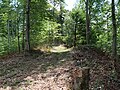 Schneitberg Burgstelle Herten Hagenbuch ZH.jpg 5,184 × 3,888; 8 MB
