Category:Bureau of Land Management areas
Jump to navigation
Jump to search
States of the United States: Alaska · Arizona · California · Colorado · Idaho · Montana · Nevada · New Mexico · Oregon · Utah · Washington · Wyoming
English: Bureau of Land Management areas in the United States — managed–protected–developed by the U.S. Bureau of Land Management.
Wikimedia category | |||||
| Upload media | |||||
| Instance of | |||||
|---|---|---|---|---|---|
| |||||
Subcategories
This category has the following 4 subcategories, out of 4 total.
*
Media in category "Bureau of Land Management areas"
The following 172 files are in this category, out of 172 total.
-
 BLM Wilderness Study Areas.jpeg 478 × 600; 61 KB
-
 Abert Rim & Lake Abert.jpg 2,550 × 3,300; 2.2 MB
-
 Abert Rim WSA.jpg 2,550 × 3,300; 1.04 MB
-
 Airport Allotment 2017.jpg 1,275 × 1,650; 221 KB
-
 Alsea Falls Recreation Site Map.jpg 1,700 × 2,200; 398 KB
-
 Alsea Falls Recreation Site.jpg 2,550 × 3,300; 1.61 MB
-
 Bald Mountain Creek Wild and Scenic River Location.jpg 3,300 × 2,550; 634 KB
-
 Bald Mountain Creek Wild and Scenic River Map.jpg 7,800 × 5,400; 2.66 MB
-
 Basque Hills WSA.jpg 2,550 × 3,300; 1.1 MB
-
 Bastendorff Beach.jpg 2,550 × 3,300; 1.07 MB
-
 Beaver Dam Creek WSA.jpg 2,550 × 3,300; 1,013 KB
-
 Black Hills Area of Critical Environmental Concern.jpg 2,550 × 3,300; 1.11 MB
-
 Blitzen River WSA.jpg 2,550 × 3,300; 1.15 MB
-
 Blue Canyon WSA.jpg 2,550 × 3,300; 902 KB
-
 Bowden Hills WSA.jpg 2,550 × 3,300; 882 KB
-
 Brewer Spruce ISA.jpg 2,550 × 3,300; 1.42 MB
-
 Bridge Creek WSA.jpg 2,550 × 3,300; 995 KB
-
 Camp Creek WSA.jpg 2,550 × 3,300; 1,020 KB
-
 Cape Blanco Lighthouse (BLM map).jpg 2,550 × 3,300; 998 KB
-
 Carpenter Bypass Mountain Bike Trail System.jpg 2,550 × 3,300; 1.91 MB
-
 Castle Rock WSA.jpg 2,550 × 3,300; 1.25 MB
-
 Cathedral Hills Trail System.jpg 2,550 × 3,300; 975 KB
-
 Cavitt Creek Falls Recreation Site.jpg 2,550 × 3,300; 1.15 MB
-
 Cedar Mountain WSA.jpg 2,550 × 3,300; 917 KB
-
 Chickahominy Recreation Site.jpg 2,550 × 3,300; 1.02 MB
-
 Christmas Valley Back Country Byway.jpg 2,200 × 1,700; 651 KB
-
 Clarks Butte WSA.jpg 2,550 × 3,300; 891 KB
-
 Clay Creek Recreation Site.jpg 3,300 × 2,550; 1.36 MB
-
 Cline Buttes OHV Trail System.jpg 3,300 × 2,550; 1.51 MB
-
 CNHT-Applegate Route Klamath Mountains.jpg 5,400 × 7,200; 37.16 MB
-
 CNHT-Applegate Route Lower Willamette Valley.jpg 5,400 × 7,200; 30.44 MB
-
 CNHT-Applegate Route Siskiyou Mountains.jpg 10,800 × 7,200; 49.01 MB
-
 Cottonwood Creek WSA.jpg 2,550 × 3,300; 1.05 MB
-
 Cougar Well WSA.jpg 2,550 × 3,300; 850 KB
-
 Dean Creek Elk Viewing Area.jpg 3,300 × 2,550; 1.23 MB
-
 Derrick Cave.jpg 2,550 × 3,300; 1.64 MB
-
 Devils Garden Lava Bed WSA.jpg 2,550 × 3,300; 865 KB
-
 Diablo Mountain WSA.jpg 2,550 × 3,300; 1.27 MB
-
 Diamond Craters Outstanding Natural Area.jpg 2,550 × 3,300; 2.06 MB
-
 Disaster Peak WSA.jpg 2,550 × 3,300; 1,021 KB
-
 Doerner Fir Trail.jpg 3,300 × 2,550; 1.63 MB
-
 Douglas Fir ISA.jpg 2,550 × 3,300; 1.16 MB
-
 Dry Creek Buttes WSA.jpg 2,550 × 3,300; 969 KB
-
 Dry Creek WSA.jpg 2,550 × 3,300; 866 KB
-
 Dry River Canyon Trail.jpg 3,300 × 2,550; 1.44 MB
-
 East Applegate Ridge Trail map - 50116373731.jpg 2,550 × 3,300; 726 KB
-
 East Applegate Ridge Trail map.jpg 8,800 × 6,800; 1.78 MB
-
 Edson Creek Recreation Site.jpg 3,300 × 2,550; 1.25 MB
-
 Eight Dollar Mountain and Jeffrey Pine Loop Trails.jpg 2,550 × 3,300; 1.64 MB
-
 Elk Creek Wild and Scenic River Map.jpg 2,850 × 3,600; 1.04 MB
-
 Enchanted Forest-Felton Memorial Trail.jpg 2,550 × 3,300; 3 MB
-
 Fifteenmile Creek WSA.jpg 2,550 × 3,300; 989 KB
-

-
 Figure 1- Bureau of Land Management-Managed Lands (19236097624).jpg 2,273 × 1,571; 236 KB
-
 Fish Trap Recreation Area.jpg 2,850 × 3,600; 939 KB
-
 Fishermen's Bend Recreation Site.jpg 2,550 × 3,300; 1.47 MB
-
 Fishtrap Recreation Area.jpg 2,550 × 3,300; 1.52 MB
-
 Four Craters Lava Bed WSA.jpg 2,550 × 3,300; 885 KB
-
 Gerber Recreation Area.jpg 2,550 × 3,300; 1.51 MB
-
 Gerry Mountain WSA.jpg 2,550 × 3,300; 867 KB
-
 Gold Creek WSA.jpg 2,550 × 3,300; 1.26 MB
-
 Grande Ronde.jpg 3,300 × 2,550; 1.44 MB
-
 Grizzly Peak Trail.jpg 2,550 × 3,300; 1.3 MB
-
 Guano Creek WSA.jpg 2,550 × 3,300; 925 KB
-
 Hampton Butte WSA.jpg 2,550 × 3,300; 851 KB
-
 Hawk Mountain WSA.jpg 2,550 × 3,300; 979 KB
-
 Heath Lake WSA.jpg 2,550 × 3,300; 951 KB
-
 Home Creek WSA.jpg 2,550 × 3,300; 960 KB
-
 Homestead WSA.jpg 2,550 × 3,300; 1,013 KB
-
 Honeycombs WSA.jpg 2,550 × 3,300; 926 KB
-
 Hungate Canyon, Moses Coulee, Columbia River Plateau.jpg 9,600 × 7,200; 11.61 MB
-
 Huntington Wagon Road.jpg 3,300 × 2,550; 1.37 MB
-
 Indian Creek - Pine Creek - Sheep Gulch WSAs.jpg 2,550 × 3,300; 1.21 MB
-
 Jenny Creek Wild and Scenic River Map - 49381792366.jpg 3,825 × 5,016; 1.53 MB
-
 Jordan Craters WSA.jpg 2,550 × 3,300; 942 KB
-
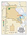 Jordan Craters.jpg 2,550 × 3,300; 1.76 MB
-
 Juniper Dunes map.jpg 1,700 × 2,200; 774 KB
-
 Juniper Dunes Wilderness and OHV Area.jpg 2,550 × 3,300; 1.8 MB
-
 Keeney Pass Interpretive Site.jpg 2,550 × 3,300; 1.25 MB
-
 Lake Creek Falls Recreation Site.jpg 2,550 × 3,300; 1.01 MB
-
 Leslie Gulch.jpg 3,300 × 2,550; 1.39 MB
-
 Liberty Recreation Site.jpg 2,550 × 3,300; 1.17 MB
-
 Little North Fork Recreation Area.jpg 3,300 × 2,550; 1.46 MB
-
 Little Sink ISA.jpg 2,550 × 3,300; 719 KB
-
 Lobster Creek Wild and Scenic River Map.jpg 3,800 × 4,800; 1.53 MB
-
 Lookout Butte WSA.jpg 2,550 × 3,300; 933 KB
-
 Lost Forest ISA.jpg 2,550 × 3,300; 811 KB
-
 Lower John Day WSA.jpg 2,550 × 3,300; 814 KB
-
 Lower Stonehouse WSA.jpg 2,550 × 3,300; 1.1 MB
-
 Mahogany Ridge WSA.jpg 2,550 × 3,300; 1.08 MB
-
 Malheur River - Bluebucket WSA.jpg 2,550 × 3,300; 1.13 MB
-
 Map of Pacific Northwest National Scenic Trail.jpg 7,200 × 5,400; 31.89 MB
-
 Maston Trail Use Area.jpg 3,300 × 2,550; 1.7 MB
-
 McGraw Creek WSA.jpg 2,550 × 3,300; 2.6 MB
-
 MckenzieRiver map.jpg 1,650 × 1,275; 338 KB
-
 Millican Valley OHV Trail System.jpg 2,550 × 3,300; 1.94 MB
-
 Molalla Wild and Scenic River Map.jpg 8,250 × 10,500; 7.29 MB
-
 Mountain Lakes WSA.jpg 2,550 × 3,300; 985 KB
-
 Mountain of the Rogue Trail System.jpg 2,550 × 3,300; 2.74 MB
-
 My Public Lands Magazine, Spring 2015 (16602531726).jpg 2,800 × 3,550; 7.55 MB
-
 My Public Lands Roadtrip- Eastern States (18373042616).jpg 2,048 × 1,365; 1.42 MB
-
 My Public Lands Roadtrip- Louisiana Bayou (18399230355).jpg 1,022 × 644; 374 KB
-
 My Public Lands Roadtrip- Louisiana Swamps (17959360864).jpg 600 × 370; 64 KB
-
 My Public Lands Roadtrip- Louisiana Swamps (18394369470).jpg 600 × 378; 52 KB
-

-

-
 Nestucca River Recreation Area.jpg 3,300 × 2,550; 1.66 MB
-
 North Fork Silver Creek Wild and Scenic River Map.jpg 6,000 × 7,500; 3.79 MB
-
 North Fork WSA.jpg 2,550 × 3,300; 980 KB
-
 North Pole Ridge WSA.jpg 2,550 × 3,300; 1.62 MB
-
 Oregon Badlands Wilderness (BLM map).jpg 3,300 × 2,550; 2 MB
-
 Oregon Canyon WSA.jpg 2,550 × 3,300; 950 KB
-
 Oregon road grant map, 1879.jpg 10,083 × 7,150; 35.32 MB
-
 Oregon Wilderness Study Areas.jpg 6,000 × 4,800; 6.51 MB
-
 Orejana Canyon WSA.jpg 2,550 × 3,300; 892 KB
-
 Pacific Crest Trail.jpg 2,550 × 3,300; 1.68 MB
-
 Palmer Mountain and Split Rock.jpg 2,550 × 3,300; 1.33 MB
-
 Palomino Hills WSA.jpg 2,550 × 3,300; 928 KB
-
 Pats Cabin WSA.jpg 2,550 × 3,300; 1.37 MB
-
 Priest Hole Recreation Area.jpg 3,300 × 2,550; 2.59 MB
-
 Provolt Recreation Site Map.jpg 1,700 × 2,200; 298 KB
-
 Red Mountain WSA.jpg 2,550 × 3,300; 963 KB
-
 Redmond Caves.jpg 3,300 × 2,550; 1.17 MB
-
 Reynolds Pond Recreation Site.jpg 3,300 × 2,550; 957 KB
-
 Rincon WSA.jpg 2,550 × 3,300; 1.01 MB
-
 Saddle Butte WSA.jpg 2,550 × 3,300; 952 KB
-
 Sage Hen Hills WSA.jpg 2,550 × 3,300; 794 KB
-
 San Juan Islands Map (High Resolution).jpg 1,650 × 1,276; 2.04 MB
-
 San Juan Islands Map.jpg 792 × 612; 432 KB
-
 Sand Dunes WSA - Lost Forest ISA.jpg 2,550 × 3,300; 784 KB
-
 Sand Hollow WSA.jpg 2,550 × 3,300; 1,019 KB
-
 Sharps Creek Recreation Site.jpg 2,550 × 3,300; 1.03 MB
-
 Sheep Mountain WSA.jpg 2,550 × 3,300; 1.43 MB
-
 Sheepshead Mountains WSA.jpg 2,550 × 3,300; 1.02 MB
-
 Shotgun Creek OHV Staging Area.jpg 3,300 × 2,550; 1.89 MB
-
 Shotgun Creek Recreation Site.jpg 2,550 × 3,300; 1.41 MB
-
 Sixes River Recreation Site.jpg 3,300 × 2,550; 1.06 MB
-
 Slocum Creek WSA.jpg 2,550 × 3,300; 1.21 MB
-
 Smith River Recreation Site.jpg 3,300 × 2,550; 1.01 MB
-
 Soda Mtn Wilderness.jpg 3,000 × 1,429; 3.89 MB
-
 South Fork Clackamas Wild and Scenic River - 28748030582.jpg 3,300 × 5,100; 1.32 MB
-
 South Fork WSA.jpg 2,550 × 3,300; 852 KB
-
 Sperry Creek WSA.jpg 2,550 × 3,300; 1.07 MB
-
 Spring Basin Wilderness (BLM map).jpg 4,800 × 6,000; 11.43 MB
-
 Spring basin wilderness 01.jpg 1,200 × 1,500; 1.57 MB
-
 Spring Recreation Site.jpg 2,550 × 3,300; 1.34 MB
-
 Squaw Ridge Lava Bed WSA.jpg 2,550 × 3,300; 877 KB
-
 Stonehouse WSA.jpg 2,550 × 3,300; 1.04 MB
-
 Sutton Mountain Backcountry Byway.jpg 3,300 × 2,550; 2.31 MB
-
 Sutton Mountain WSA.jpg 2,550 × 3,300; 982 KB
-
 Table Mountain WSA.jpg 2,550 × 3,300; 924 KB
-
 Table Rocks Trails.jpg 3,300 × 2,550; 1.49 MB
-
 Thirtymile WSA.jpg 2,550 × 3,300; 1.44 MB
-
 Topsy Campground.jpg 5,100 × 6,600; 3.09 MB
-
 Twelvemile Creek WSA.jpg 2,550 × 3,300; 959 KB
-
 Twin Lakes Recreation Area.jpg 3,300 × 2,550; 1.68 MB
-
 Upper Leslie Gulch WSA.jpg 2,550 × 3,300; 1.81 MB
-
 Upper West Little Owyhee WSA.jpg 2,550 × 3,300; 962 KB
-
 Virtue Flat Trail Guide 2018.jpg 7,378 × 4,774; 3.2 MB
-
 Walker Creek Wild and Scenic River Map.jpg 6,000 × 7,500; 2.46 MB
-
 Wasson Creek Wild and Scenic River Location Map.jpg 3,300 × 2,550; 842 KB
-
 West Peak WSA.jpg 2,550 × 3,300; 1.01 MB
-
 Western Juniper ISA.jpg 2,550 × 3,300; 752 KB
-
 White River Wilderness.jpg 7,368 × 3,800; 6.91 MB
-
 White river wilderness.jpg 1,500 × 808; 715 KB
-
 Whittaker Creek Recreation Site.jpg 3,300 × 2,550; 1.03 MB
-
 Wildcat Canyon WSA.jpg 2,550 × 3,300; 860 KB
-
 Wildhorse Basin WSA.jpg 2,550 × 3,300; 895 KB
-
 Willow Creek WSA.jpg 2,550 × 3,300; 1,018 KB
-
 Winter Range WSA.jpg 2,550 × 3,300; 893 KB
-
 Wolf Creek Recreation Area.jpg 2,550 × 3,300; 1.34 MB
-
 Woodrat Mountain Launch Sites.jpg 3,300 × 2,550; 1.59 MB


.jpg)


.jpg)
.jpg)


.jpg)
.jpg)
.jpg)
.jpg)
.jpg)
.jpg)
.jpg)


.jpg)


.jpg)


.jpg)


