Category:Bunker de l'Abbiette (Fromelles)
Jump to navigation
Jump to search
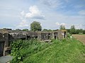
Casemate à mitrailleuse 28, dite Teufelgraben, puis de l'Abbiette, de type Müller de 1917
| Object location | | View all coordinates using: OpenStreetMap |
|---|
|
This building is indexed in the base Mérimée, a database of architectural heritage maintained by the French Ministry of Culture, under the reference IA59004858
|
.jpg) | |||||
| Upload media | |||||
| Location |
| ||||
|---|---|---|---|---|---|
 | |||||
Media in category "Bunker de l'Abbiette (Fromelles)"
The following 8 files are in this category, out of 8 total.
-
 Fromelles Blockhaus LAbbiette.jpg 3,648 × 2,736; 3.58 MB
-
 Fromelles bunker.JPG 4,000 × 3,000; 4.69 MB
-
 Fromelles le bunker de l'Abbiette (1).jpg 4,896 × 3,672; 7.06 MB
-
 Fromelles le bunker de l'Abbiette (4).jpg 4,896 × 3,672; 6.51 MB
-
 Fromelles le bunker de l'Abbiette IA59004858 (1).jpg 4,829 × 2,289; 3.69 MB
-
 Fromelles le bunker de l'Abbiette IA59004858 (2).jpg 4,828 × 1,788; 2.19 MB
-
 Fromelles le bunker de l'Abbiette IA59004858 (3).jpg 3,902 × 2,234; 2.34 MB
-
 Fromelles le bunker de l'Abbiette IA59004858 (4).jpg 4,896 × 3,672; 3.9 MB


.jpg)
.jpg)
.jpg)
.jpg)
.jpg)