Category:Bunker Saragossa
Jump to navigation
Jump to search
| Object location | | View all coordinates using: OpenStreetMap |
|---|
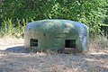
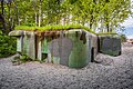
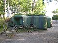
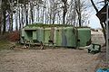
Polski: Ośrodek Oporu Jastarnia - schron bojowy Saragossa, 1939
 | |||||
| Upload media | |||||
| Part of | |||||
|---|---|---|---|---|---|
| Location | Jastarnia, Puck County, Pomeranian Voivodeship, Poland | ||||
| Heritage designation |
| ||||
| Inception |
| ||||
 | |||||
Media in category "Bunker Saragossa"
The following 16 files are in this category, out of 16 total.
-
 Bunker Saragossa 01.jpg 2,225 × 1,481; 700 KB
-
 Bunker Saragossa 02.jpg 2,496 × 1,664; 1.01 MB
-
 Ciężki schron bojowy Saragossa (1939 r.) - Jastarnia - panoramio.jpg 1,024 × 671; 224 KB
-
 Hel2 A-1200 z 1999-06-15.jpg 2,880 × 1,920; 5.12 MB
-
 Jastarnia, "Saragossa" Heavy bunker - panoramio.jpg 2,592 × 1,728; 2.97 MB
-
 Jastarnia, schron bojowy Saragossa (WLZ14).jpg 3,775 × 2,500; 5.75 MB
-
 Jastarnia, schron bojowy Saragossa 1 (WLZ14).jpg 3,800 × 2,400; 5.29 MB
-
 Jastarnia, schron bojowy Saragossa 2 (WLZ14).jpg 3,775 × 2,500; 6.43 MB
-
 Jastarnia, schron bojowy Saragossa.jpg 3,072 × 2,304; 2.26 MB
-
 Schron bojowy "Saragossa" wejście.JPG 2,864 × 4,288; 2.18 MB
-
 Schron bojowy "Saragossa" wnętrze.JPG 4,288 × 2,864; 1.97 MB
-
 Schron bojowy "Saragossa".JPG 4,288 × 2,864; 5.57 MB
-
 Schron Saragodda.jpg 3,264 × 2,448; 3.62 MB
-
 Schron Saragossa 1.JPG 1,728 × 1,152; 510 KB
-
 Schron Saragossa 2.jpg 1,728 × 1,152; 426 KB
-
 Schron Saragossa 3.jpg 1,728 × 1,152; 390 KB

_-_Jastarnia_-_panoramio.jpg)


.jpg)
.jpg)
.jpg)


