Category:Bundesverwaltungsgebäude (1902–1904) Hallwylstrasse 4, Bern
Jump to navigation
Jump to search
| Object location | | View all coordinates using: OpenStreetMap |
|---|
administrative building at Hallwylstrasse in the city of Bern, Switzerland  | |||||
| Upload media | |||||
| Instance of |
| ||||
|---|---|---|---|---|---|
| Part of | |||||
| Location | Kirchenfeld, Kirchenfeld-Schosshalde, Bern, Bern-Mittelland administrative district, Bernese Mittelland administrative region, Bern, Switzerland | ||||
| Street address |
| ||||
| Owned by | |||||
| Occupant |
| ||||
| Inception |
| ||||
 | |||||
Media in category "Bundesverwaltungsgebäude (1902–1904) Hallwylstrasse 4, Bern"
The following 3 files are in this category, out of 3 total.
-
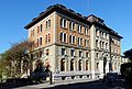 Bern Hallwylstrasse 4.jpg 4,056 × 2,744; 2.47 MB
-
 Hans Zölly TA5144a 1925.jpg 3,748 × 5,796; 10.38 MB
-
 Wettbewerbskommission Eingangsschild.jpg 3,456 × 4,608; 6.39 MB

