Category:Bryce Canyon Airport
Jump to navigation
Jump to search
airport in Garfield County, Utah, United States of America  | |||||
| Upload media | |||||
| Instance of | |||||
|---|---|---|---|---|---|
| Location | Garfield County, Utah | ||||
| Architectural style | |||||
| Heritage designation | |||||
| Elevation above sea level |
| ||||
| IATA airport code |
| ||||
| ICAO airport code |
| ||||
 | |||||
English: Media related to Bryce Canyon Airport, a historic public airport located 4 miles (6.4 km) north of Bryce Canyon City, Garfield County, Utah, United States, that is owned by Garfield County and is listed on the National Register of Historic Places.
IATA: BCE
ICAO: KBCE
|
This is a category about a place or building that is listed on the National Register of Historic Places in the United States of America. Its reference number is 78002660. |
Media in category "Bryce Canyon Airport"
The following 6 files are in this category, out of 6 total.
-
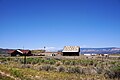
 Bryce Airport - Life on the Wilds, Oct 17.jpg 2,592 × 1,944; 2.41 MB
-
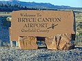 Bryce Canyon Airport sign, Oct 17.jpg 2,592 × 1,944; 2.29 MB
-
 Bryce Canyon Airport, Utah (2018).jpg 6,000 × 4,000; 7.38 MB
-
 Bryce Canyon Airport.jpeg 3,008 × 2,000; 2.67 MB
-
 Northwest at Bryce Canyon Airport from SR-12, Oct 17.jpg 2,592 × 1,944; 2.41 MB
-
 Tragedy and Triumph - Emergency Landings, Oct 17.jpg 2,592 × 1,944; 2.37 MB


.jpg)


Categories:
- Airports in Utah
- National Register of Historic Places in Garfield County, Utah
- Transportation on the National Register of Historic Places in Utah
- Built in Utah in 1938
- Airports in the United States by name
- Transport in Garfield County, Utah
- Johns Valley (Utah)
- Emery Valley
- Paunsaugunt Plateau
- Works Progress Administration in Utah
- Locales in Garfield County, Utah
- Locations along Utah State Route 12 in Garfield County, Utah