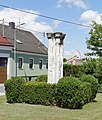
Category:Brotlaibsäule (Zistersdorf)
Jump to navigation
Jump to search
| Object location | | View all coordinates using: OpenStreetMap |
|---|
 | |||||
| Upload media | |||||
| Instance of | |||||
|---|---|---|---|---|---|
| Location | Zistersdorf, Gänserndorf District, Lower Austria, Austria | ||||
| Heritage designation | |||||
 | |||||
Media in category "Brotlaibsäule (Zistersdorf)"
The following 3 files are in this category, out of 3 total.
-
 Brotlaibsäule 9577 in A-2225 Zistersdorf.jpg 4,000 × 4,703; 4.96 MB
-
 NOE Zistersdorf Neustiftgasse 3-Detail.jpg 2,176 × 3,264; 3.14 MB
-
 NOE Zistersdorf Neustiftgasse 3.jpg 3,166 × 2,166; 4.38 MB

