Category:Brislington West (ward)
Jump to navigation
Jump to search
electoral ward of the unitary authority of Bristol   | |||||
| Upload media | |||||
| Instance of |
| ||||
|---|---|---|---|---|---|
| Location | City of Bristol, South West England, England | ||||
 | |||||
Subcategories
This category has the following 3 subcategories, out of 3 total.
A
- Arno's Court Triumphal Arch (12 F)
Media in category "Brislington West (ward)"
The following 34 files are in this category, out of 34 total.
-
 Neale(1818) p3.322 - Wick House, Somersetshire.jpg 1,808 × 1,216; 634 KB
-
 A bit parky for a picnic - geograph.org.uk - 5696547.jpg 2,304 × 1,704; 2.01 MB
-
 Already down before the snow - geograph.org.uk - 5710579.jpg 2,304 × 1,704; 2.05 MB
-
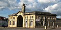
 Arno's Court Triumphal Arch - geograph.org.uk - 5911171.jpg 4,000 × 3,000; 2.87 MB
-
 Beechwood Close, Bristol - geograph.org.uk - 5707980.jpg 4,283 × 2,612; 1.28 MB
-
 Being taken for a walk by the dog - geograph.org.uk - 5710581.jpg 2,304 × 1,704; 1.8 MB
-
 Benchmark on buttress of St Anne's Church - geograph.org.uk - 5664295.jpg 1,024 × 683; 299 KB
-

-
 Brislington old tram depot.jpg 1,024 × 512; 180 KB
-
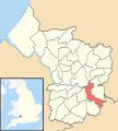 Brislington West Bristol UK ward map.svg 1,138 × 1,266; 709 KB
-
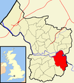 Bristol brislington.png 702 × 780; 149 KB
-
 Bristol MMB «85 North Somerset Railway.jpg 2,400 × 1,600; 3.05 MB
-
 Can't see the line markings^ - geograph.org.uk - 5696548.jpg 2,304 × 1,704; 1.08 MB
-
 Choke Walk - geograph.org.uk - 5696566.jpg 2,304 × 1,704; 1.31 MB
-
 Covering over the tracks - geograph.org.uk - 5696609.jpg 2,304 × 1,704; 1.15 MB
-
 Houses by Sturminster Road, Bristol - geograph.org.uk - 5707975.jpg 4,135 × 2,584; 1.89 MB
-
 Hungerford Community Centre - geograph.org.uk - 5696604.jpg 2,304 × 1,704; 1.35 MB
-
 Langton Road Bristol - geograph.org.uk - 5560128.jpg 1,944 × 2,592; 1,022 KB
-
 No chance of getting muddy - geograph.org.uk - 5696544.jpg 2,304 × 1,704; 962 KB
-
 Not just pubs that get converted - geograph.org.uk - 5696584.jpg 2,304 × 1,704; 1.78 MB
-
 Old school buildings - geograph.org.uk - 6078936.jpg 2,048 × 1,536; 868 KB
-
 Park and ride - for your sleigh - geograph.org.uk - 5696570.jpg 2,304 × 1,704; 1.33 MB
-
 Protected from the wayward - geograph.org.uk - 5696605.jpg 2,304 × 1,704; 1.45 MB
-
 Red cliff - geograph.org.uk - 5994425.jpg 1,024 × 774; 187 KB
-
 Rosedale House Care Home - geograph.org.uk - 6124904.jpg 4,000 × 3,000; 2.46 MB
-
 St Anne's Church, Langton Road - geograph.org.uk - 5664298.jpg 1,024 × 683; 147 KB
-
 Sturminster Road, Bristol - geograph.org.uk - 5703171.jpg 4,288 × 2,848; 2.16 MB
-
 Suitably decorated - geograph.org.uk - 5696592.jpg 2,304 × 1,704; 1.9 MB
-
 The snow has reduced the congestion - geograph.org.uk - 5696595.jpg 2,304 × 1,704; 1.63 MB
-
 West Town Lane, Bristol - geograph.org.uk - 5707985.jpg 4,249 × 2,429; 1.65 MB
-
 What does snow mean^ - geograph.org.uk - 5696599.jpg 2,304 × 1,704; 1.59 MB
-
 Wintery wassail - geograph.org.uk - 5710568.jpg 2,304 × 1,704; 2.01 MB
-
 You'll have to wait a bit longer for the apple blossom - geograph.org.uk - 5710571.jpg 2,304 × 1,704; 2.44 MB
-
 ^224 Bloomfield Road at Buckingham Road junction - geograph.org.uk - 5664325.jpg 1,024 × 683; 156 KB
_p3.322_-_Wick_House,_Somersetshire.jpg)


