Category:Braughing
Jump to navigation
Jump to search
English: Braughing is a village and civil parish, between the rivers Quin and Rib, in the non-metropolitan district of East Hertfordshire, part of the English county of Hertfordshire, England. Braughing was a rural district in Hertfordshire from 1935 to 1974.
village and civil parish in Hertfordshire, England, UK  | |||||
| Upload media | |||||
| Instance of | |||||
|---|---|---|---|---|---|
| Location | East Hertfordshire, Hertfordshire, East of England, England | ||||
| official website | |||||
 | |||||
Subcategories
This category has the following 10 subcategories, out of 10 total.
A
B
- Braughing Bourne (5 F)
- Braughing railway station (5 F)
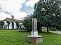
- Braughing War Memorial (1 F)
- Brown Bear, Braughing (2 F)
D
- Dassels (4 F)
F
- Ford at Braughing (12 F)
M
Media in category "Braughing"
The following 122 files are in this category, out of 122 total.
-
 (0994) Clepsis consimilana (7501334726).jpg 1,200 × 836; 1.09 MB
-
 16, The Street, Braughing (8009286576).jpg 4,288 × 3,216; 4.64 MB
-
 30 limit though Hay Street - geograph.org.uk - 6063420.jpg 1,024 × 684; 281 KB
-
 A field next to The Causeway - geograph.org.uk - 473359.jpg 640 × 480; 63 KB
-
 A10, southbound - geograph.org.uk - 4790519.jpg 640 × 426; 57 KB
-
 A10, southbound - geograph.org.uk - 4790520.jpg 640 × 426; 58 KB
-
 Ash tree and cow parsley at roadside - geograph.org.uk - 4494162.jpg 4,320 × 3,240; 5.25 MB
-
 B1368 at Braughing - geograph.org.uk - 3584113.jpg 640 × 360; 85 KB
-
 B1368 near Hay Street, Hertfordshire - geograph.org.uk - 1880340.jpg 1,024 × 768; 449 KB
-
 B1368 near Hay Street, Hertfordshire - geograph.org.uk - 1880824.jpg 1,024 × 768; 312 KB
-
 B1368 Station Road, Braughing - geograph.org.uk - 6063401.jpg 1,024 × 684; 328 KB
-
 B1368 through Dassells - geograph.org.uk - 6063429.jpg 1,024 × 684; 335 KB
-
 B1368 through Green End - geograph.org.uk - 5862208.jpg 1,600 × 1,252; 328 KB
-
 B1368, Green End, Braughing - geograph.org.uk - 6063410.jpg 1,024 × 684; 292 KB
-
 Barley field near May Trees - geograph.org.uk - 4535686.jpg 4,320 × 3,240; 2.96 MB
-
 Benedict, Braughing (8009277959).jpg 4,288 × 3,216; 4.09 MB
-
 Braughing from the air - geograph.org.uk - 3844579.jpg 640 × 394; 98 KB
-
 Braughing from the air - geograph.org.uk - 3844596.jpg 640 × 480; 115 KB
-
 Braughing Village Centre, Hertfordshire - geograph.org.uk - 2027093.jpg 1,024 × 768; 271 KB
-
 Braughing Village Sign - geograph.org.uk - 1882377.jpg 768 × 1,024; 378 KB
-
 Braughing War Memorial - geograph.org.uk - 3584145.jpg 640 × 360; 97 KB
-
 Braughing, Bridleway to Bozen Green - geograph.org.uk - 2477563.jpg 640 × 480; 67 KB
-
 Braughing, Bridleway to Rotten Row - geograph.org.uk - 2477580.jpg 640 × 480; 68 KB
-
 Braughing, Flooded Horse Cross lane - geograph.org.uk - 3818045.jpg 640 × 480; 77 KB
-

-
 Braughing, Herts - geograph.org.uk - 118202.jpg 640 × 480; 109 KB
-
-

-

-
 Braughing- Church End (geograph 2480242).jpg 640 × 480; 71 KB
-
 Bridge, Braughing - geograph.org.uk - 1886623.jpg 768 × 1,024; 482 KB
-
 Bridleway to Patmoreheath - geograph.org.uk - 473277.jpg 640 × 480; 79 KB
-
 Churchyard, St Mary the Virgin, Braughing - geograph.org.uk - 1890719.jpg 1,024 × 768; 450 KB
-

-

-
 Cottage, Braughing - geograph.org.uk - 1881442.jpg 1,024 × 768; 341 KB
-
-
 Cottages on The Street, Braughing - geograph.org.uk - 4830821.jpg 2,304 × 1,728; 1,001 KB
-
 Cow Parsley near Hay Street, Hertfordshire - geograph.org.uk - 1880827.jpg 1,024 × 613; 469 KB
-
 Depth Gauge, Braughing Ford - geograph.org.uk - 1882593.jpg 1,024 × 768; 489 KB
-
 Dusk over Braughing - geograph.org.uk - 4831568.jpg 2,238 × 1,591; 702 KB
-
 Entrance to Hamels Park - geograph.org.uk - 275698.jpg 640 × 428; 109 KB
-
 Entrance to Hamels Park - geograph.org.uk - 471710.jpg 640 × 480; 106 KB
-
 Entrance to St Mary the Virgin, Braughing - geograph.org.uk - 1890710.jpg 1,024 × 768; 456 KB
-
 Farmhouse at Fordstreet, Braughing - geograph.org.uk - 4493940.jpg 4,320 × 3,240; 3.46 MB
-
 Field by The Causeway near Patient End - geograph.org.uk - 4831554.jpg 2,304 × 1,728; 913 KB
-
 Field margin near Bozen Green - geograph.org.uk - 4494152.jpg 4,320 × 3,240; 4.26 MB
-
 Field of wheat, near Braughing Friars - geograph.org.uk - 2475694.jpg 3,008 × 2,000; 3.15 MB
-
 Fleece Lane, Braughing - geograph.org.uk - 1886655.jpg 1,024 × 768; 427 KB
-
 Ford at Braughing - geograph.org.uk - 3584156.jpg 640 × 360; 84 KB
-
 Ford Street, Braughing - geograph.org.uk - 3584150.jpg 640 × 360; 107 KB
-
 Former railway, Braughing - geograph.org.uk - 3584137.jpg 640 × 360; 63 KB
-
 Geese crossing Braughing Ford, Hertfordshire - geograph.org.uk - 2027058.jpg 1,024 × 768; 214 KB
-
 Geese drinking in Braughing Ford, Hertfordshire - geograph.org.uk - 2027063.jpg 1,024 × 768; 220 KB
-
 Geese, Braughing Ford, Hertfordshire - geograph.org.uk - 2027071.jpg 1,024 × 768; 454 KB
-
 GOC Braughing 091 1-4 Ford Street, Braughing (8451979677).jpg 3,974 × 2,488; 2.61 MB
-
 GOC Braughing 092 Fordstreet Farm, Braughing (8454686243).jpg 2,899 × 2,181; 2.27 MB
-
 GOC Braughing 093 8 Ford Street, Braughing (8455780524).jpg 3,016 × 2,264; 2.18 MB
-
 GOC Braughing 094 Braughing village sign (8454686671).jpg 2,054 × 2,999; 1.58 MB
-
 GOC Braughing 097 River Quin and Malting Lane Ford, Braughing (8454687141).jpg 4,288 × 3,216; 4.37 MB
-
 GOC Braughing 099 3-8 Malting Lane, Braughing (8454687469).jpg 3,583 × 2,693; 2.87 MB
-
 GOC Braughing 101 1 The Street, Braughing (8458215556).jpg 3,501 × 2,623; 2.94 MB
-
 GOC Braughing 103 Braughing Methodist Church (8458216142).jpg 3,904 × 2,933; 2.97 MB
-
 Goose on guard, Braughing - geograph.org.uk - 1881431.jpg 1,024 × 768; 347 KB
-
 Green Hill Close, Braughing, Hertfordshire - geograph.org.uk - 2027084.jpg 1,024 × 768; 413 KB
-
 Green Hill Close, Braughing, Hertfordshire - geograph.org.uk - 2027088.jpg 1,024 × 768; 436 KB
-
 Hay Street, B1368 to Hare Street - geograph.org.uk - 2480042.jpg 640 × 480; 61 KB
-
 Heading up to Rotten Row - geograph.org.uk - 720284.jpg 640 × 425; 74 KB
-
 Hertfordshire landscape, near Braughing Friars - geograph.org.uk - 2475098.jpg 2,669 × 1,781; 1.95 MB
-
 House round corner from the Church, Braughing - geograph.org.uk - 1881414.jpg 1,024 × 768; 419 KB
-
 House with wind turbine - geograph.org.uk - 471699.jpg 640 × 480; 75 KB
-
 Houses in Church End, Braughing - geograph.org.uk - 4494091.jpg 4,320 × 3,240; 4.66 MB
-
 Ideal Farm at Braughing Friars - geograph.org.uk - 5478108.jpg 3,264 × 2,448; 3.46 MB
-
 Late May, the Causeway - geograph.org.uk - 4494135.jpg 4,320 × 3,240; 4.7 MB
-
 Mallards, Braughing - geograph.org.uk - 1886640.jpg 1,024 × 602; 390 KB
-
 Meadow, Braughing - geograph.org.uk - 1881447.jpg 1,024 × 768; 490 KB
-
 Meadow, Braughing - geograph.org.uk - 1881451.jpg 1,024 × 768; 444 KB
-
 Methodist chapel, Braughing - geograph.org.uk - 4493968.jpg 4,320 × 3,240; 4.27 MB
-
 Milestone 28 on B1368 in Braughing.jpg 2,736 × 3,648; 5.11 MB
-
 Milestone 29 on B1368 at Braughing.jpg 2,736 × 3,648; 4.61 MB
-
 Northbound A10 - geograph.org.uk - 5678139.jpg 640 × 428; 113 KB
-

-

-

-

-

-
 Old Milestone - geograph.org.uk - 3206784.jpg 1,024 × 768; 377 KB
-
 Old Milestone - geograph.org.uk - 3206788.jpg 768 × 1,024; 284 KB
-
 Old Milestone - geograph.org.uk - 3206794.jpg 1,024 × 768; 399 KB
-
 Old Milestone - geograph.org.uk - 3206797.jpg 768 × 1,024; 292 KB
-
 Ordnance Survey Drawings - Buntingford (OSD 142).jpg 4,000 × 2,205; 3.75 MB
-
 Part of Stortford Road - geograph.org.uk - 1214357.jpg 640 × 480; 117 KB
-
 Public bridleway near Braughing - geograph.org.uk - 3584201.jpg 640 × 360; 88 KB
-
 Quinbury Farm near Hay Street, Hertfordshire - geograph.org.uk - 1880326.jpg 1,024 × 768; 419 KB
-
 Quinbury Farm near Hay Street, Hertfordshire - geograph.org.uk - 1880330.jpg 1,024 × 616; 338 KB
-
 Recycling in the countryside. - geograph.org.uk - 473286.jpg 640 × 480; 69 KB
-
 Refurbished Braughing - geograph.org.uk - 6022997.jpg 3,264 × 2,448; 2.07 MB
-
 River Quin near Braughing - geograph.org.uk - 621817.jpg 640 × 480; 133 KB
-
 River Rib valley north of Puckeridge - geograph.org.uk - 90420.jpg 640 × 425; 77 KB
-
 River Rib valley south of Braughing - geograph.org.uk - 90426.jpg 640 × 425; 77 KB
-
 Rotten Row from the air - geograph.org.uk - 3844604.jpg 640 × 379; 96 KB
-
 Site of Braughing railway station - geograph.org.uk - 3584127.jpg 640 × 360; 84 KB
-
 Small stream seen from bridge carrying the B1368 - geograph.org.uk - 3447324.jpg 4,320 × 3,240; 5.1 MB
-
 Station Road at the junction of Ford Street - geograph.org.uk - 4830846.jpg 2,304 × 1,728; 1.78 MB
-
 Sunset over The Causeway near Braughing - geograph.org.uk - 4831559.jpg 2,304 × 1,728; 1.37 MB
-
 The Causeway, Braughing - geograph.org.uk - 3584182.jpg 640 × 360; 50 KB
-
 The Causeway, Braughing - geograph.org.uk - 3584193.jpg 640 × 360; 68 KB
-
 The Causeway, Braughing - geograph.org.uk - 4494117.jpg 4,320 × 3,240; 3.84 MB
-
 The Ex Adam and Eve P.H. - geograph.org.uk - 304369.jpg 640 × 428; 89 KB
-
 The Gables, Braughing - geograph.org.uk - 2485106.jpg 1,024 × 768; 202 KB
-
 The Gatehouse, Braughing (8009286988).jpg 4,288 × 3,216; 4.29 MB
-
 The Golden Fleece, Green End - geograph.org.uk - 5862207.jpg 1,600 × 1,200; 327 KB
-
 The road to Rotten Row. - geograph.org.uk - 473377.jpg 640 × 480; 105 KB
-
 The Street, Braughing - geograph.org.uk - 4879486.jpg 4,320 × 3,240; 4.14 MB
-
 Track near Oldfield Cottages - geograph.org.uk - 473262.jpg 640 × 480; 83 KB
-
 Unusual rendering on house in Braughing - geograph.org.uk - 1881419.jpg 1,024 × 768; 405 KB
-
 Village Centre, Braughing - geograph.org.uk - 1881436.jpg 1,024 × 768; 493 KB
-
 Village Centre, Braughing - geograph.org.uk - 1882386.jpg 1,024 × 768; 437 KB
-
 Village Pump - geograph.org.uk - 5679237.jpg 4,128 × 3,096; 2.62 MB
-
 Village Sign, Braughing - geograph.org.uk - 1886632.jpg 768 × 1,024; 408 KB
-
 Village Sign, Braughing, Essex - geograph.org.uk - 4669147.jpg 1,400 × 1,050; 1.41 MB
-
 War memorial, Braughing - geograph.org.uk - 4493929.jpg 4,320 × 3,240; 5.47 MB
_Clepsis_consimilana_(7501334726).jpg)
.jpg)


.jpg)


.jpg)


.jpg)
.jpg)
.jpg)
.jpg)
.jpg)
.jpg)
.jpg)
.jpg)


.jpg)


.jpg)


