Category:Bramcote, Nottinghamshire
Jump to navigation
Jump to search
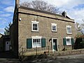
English: Bramcote is a settlement in the Broxtowe district of Nottinghamshire, about five miles south-west of Nottingham. It was a separate village but is now a suburb of Greater Nottingham. Originally one of the main roads between the cities of Nottingham and Derby (about 15 miles apart) passed through the village centre. Nowadays the main Nottingham - Derby road (the A52 - called the Brian Clough Way in honour of the late football manager who brought success to both Derby County and Nottingham Forest passes a little to the north of the village centre, partially cutting the centre from the Bramcote Hills part of the village. The original road snakes through the old centre entering a steep-sided cutting just south of the centre, forming a blind bend known as 'Devils Bend'.
village in the Broxtowe district of Nottinghamshire, England, UK | |||||
| Upload media | |||||
| Instance of | |||||
|---|---|---|---|---|---|
| Location | Broxtowe, Nottinghamshire, East Midlands, England | ||||
| Different from | |||||
 | |||||
Subcategories
This category has the following 7 subcategories, out of 7 total.
Media in category "Bramcote, Nottinghamshire"
The following 147 files are in this category, out of 147 total.
-
 "Entrance" to The Chancery - geograph.org.uk - 670858.jpg 640 × 353; 115 KB
-
 101 Town Street, Bramcote.jpg 1,024 × 768; 247 KB
-
 Alderman White College - geograph.org.uk - 1478171.jpg 640 × 479; 40 KB
-
 Alderman White College, Bramcote - geograph.org.uk - 1775697.jpg 640 × 480; 102 KB
-
 Alderman White School - geograph.org.uk - 1478850.jpg 640 × 479; 108 KB
-
 Ancient and modern - geograph.org.uk - 622440.jpg 461 × 627; 111 KB
-
 Autumn leaves at Rosedale Drive - geograph.org.uk - 612622.jpg 640 × 480; 145 KB
-

-
 Not in working order - geograph.org.uk - 622435.jpg 469 × 631; 103 KB
-
 Bramcote Almshouses - geograph.org.uk - 1775626.jpg 640 × 480; 61 KB
-
 Bramcote Hills Park - Flickr - brianfagan.jpg 5,472 × 3,648; 16.48 MB
-
 Bramcote Hills Park - geograph.org.uk - 17663.jpg 640 × 423; 60 KB
-
 Bramcote Hills PO - geograph.org.uk - 575613.jpg 640 × 426; 40 KB
-
 Bramcote Hills schools - geograph.org.uk - 622477.jpg 640 × 480; 98 KB
-
 Bramcote House Nursing Home - geograph.org.uk - 1775645.jpg 640 × 480; 71 KB
-
 Bramcote Lane, Bramcote - geograph.org.uk - 1775848.jpg 640 × 480; 115 KB
-
 Bramcote Leisure Centre - geograph.org.uk - 671786.jpg 640 × 427; 188 KB
-
 Bramcote Post Office - geograph.org.uk - 671434.jpg 640 × 430; 131 KB
-
 Bramcote Roundabout (1) - geograph.org.uk - 671455.jpg 640 × 427; 155 KB
-
 Bramcote.JPG 2,304 × 1,728; 2.69 MB
-
 Bridge in the Woods - geograph.org.uk - 1013975.jpg 640 × 480; 134 KB
-
 Bridle Road, Bramcote - geograph.org.uk - 909926.jpg 480 × 640; 117 KB
-
 Broom Hill Terrace, Bramcote.jpg 1,200 × 845; 431 KB
-
 Cemetery and Chapel - geograph.org.uk - 54412.jpg 640 × 480; 109 KB
-
 Central Avenue shops, Beeston - geograph.org.uk - 673076.jpg 640 × 427; 201 KB
-
 Chilwell Lane, Bramcote - geograph.org.uk - 1775680.jpg 640 × 480; 104 KB
-
 Chilwell Lane, Bramcote - geograph.org.uk - 1775684.jpg 640 × 480; 107 KB
-
 Chilwell Lane, Bramcote - geograph.org.uk - 1775705.jpg 640 × 480; 88 KB
-
 Chilwell Lane, Bramcote - geograph.org.uk - 1775819.jpg 640 × 480; 72 KB
-
 Chilwell Lane, Bramcote - geograph.org.uk - 1775832.jpg 640 × 480; 90 KB
-
 Chilwell Lane, Bramcote - geograph.org.uk - 1775838.jpg 640 × 480; 110 KB
-
 Common Lane, Bramcote - geograph.org.uk - 1478857.jpg 479 × 640; 123 KB
-
 Court Yard, Bramcote - geograph.org.uk - 1775621.jpg 640 × 480; 107 KB
-
 Cow Lane - geograph.org.uk - 1478165.jpg 640 × 479; 141 KB
-
 Cow Lane, Bramcote - geograph.org.uk - 1775607.jpg 640 × 480; 99 KB
-
 Doomed Row of Shops^ - geograph.org.uk - 1201195.jpg 640 × 480; 121 KB
-
 Ewe Lamb Lane - geograph.org.uk - 916155.jpg 640 × 480; 74 KB
-
 Fields near Bramcote - geograph.org.uk - 1478852.jpg 640 × 479; 76 KB
-
 Frederic Chatfield Smith MP plaque.JPG 640 × 480; 145 KB
-
 Gated Community Barrier - geograph.org.uk - 54408.jpg 616 × 462; 102 KB
-
 Good advice for cyclists^ - geograph.org.uk - 1478855.jpg 640 × 479; 133 KB
-
 Henry John Pearson and Lt. Col. Noel Jervis Pearson DSO MC plaque.jpg 640 × 484; 174 KB
-
 Informal cycling area - geograph.org.uk - 622267.jpg 640 × 480; 113 KB
-

-

-
 Kingsbridge Way - geograph.org.uk - 1478845.jpg 640 × 442; 79 KB
-
 Kingsbridge Way, Bramcote - geograph.org.uk - 1775824.jpg 640 × 480; 77 KB
-
 Lynton Road, Bramcote - geograph.org.uk - 1775841.jpg 640 × 480; 59 KB
-
 Middleton Crescent, Nottingham - geograph.org.uk - 919151.jpg 640 × 480; 114 KB
-
 Neighbour's Garden - panoramio.jpg 2,048 × 1,536; 927 KB
-
 New housing estate - geograph.org.uk - 1305247.jpg 640 × 480; 48 KB
-
 North-side of the Hedge - geograph.org.uk - 773849.jpg 640 × 427; 146 KB
-
 On Bramcote Hills - geograph.org.uk - 1478152.jpg 640 × 479; 128 KB
-
 Orton Avenue, Bramcote - geograph.org.uk - 1775709.jpg 640 × 480; 82 KB
-
 Peache Way - geograph.org.uk - 1478862.jpg 640 × 479; 133 KB
-
 Picnic Table in Bramcote Hills Park - geograph.org.uk - 1116074.jpg 640 × 426; 130 KB
-
 Playground in King Georges Park, Bramcote Geograph-767826.jpg 640 × 427; 239 KB
-
 Primary School, Bramcote - geograph.org.uk - 1775615.jpg 640 × 480; 81 KB
-
 Private Road to Manor Court, Bramcote - geograph.org.uk - 1775654.jpg 640 × 480; 152 KB
-
 Railway bridge south of Balloon Woods - geograph.org.uk - 1717802.jpg 1,534 × 1,023; 491 KB
-
 Rock cutting, Bramcote - geograph.org.uk - 1478876.jpg 640 × 479; 89 KB
-
 Sandy Lane - geograph.org.uk - 1478156.jpg 640 × 479; 138 KB
-
 Shops on Bramcote Lane - panoramio.jpg 2,048 × 1,536; 619 KB
-
 South-side of the hedge - geograph.org.uk - 773838.jpg 640 × 427; 134 KB
-
 St John's College - geograph.org.uk - 1305288.jpg 640 × 480; 72 KB
-
 St John's College - geograph.org.uk - 1478858.jpg 640 × 479; 98 KB
-
 St. John's College, Bramcote - geograph.org.uk - 1775672.jpg 640 × 480; 91 KB
-
 Sunnyside School - geograph.org.uk - 54401.jpg 640 × 480; 75 KB
-
 Sunset over Bramcote - geograph.org.uk - 1769935.jpg 640 × 480; 52 KB
-
 Telephone pole at Bramcote, Greater Nottingham.jpg 2,048 × 1,536; 310 KB
-
 Tennis Court, St John's College, Bramcote - geograph.org.uk - 667446.jpg 640 × 427; 163 KB
-
 The Grange, Bramcote - geograph.org.uk - 1775639.jpg 640 × 480; 59 KB
-
 The Home Croft - geograph.org.uk - 1478864.jpg 640 × 479; 97 KB
-
 The Home Croft, Bramcote - geograph.org.uk - 1775660.jpg 640 × 480; 75 KB
-
 The Refugee and the Hemlock Stone - geograph.org.uk - 1116067.jpg 426 × 640; 118 KB
-
 The Walled Garden, Bramcote Hills - geograph.org.uk - 622431.jpg 480 × 640; 82 KB
-
 The Walled Garden, Bramcote Hills - geograph.org.uk - 622438.jpg 470 × 631; 99 KB
-
 Town Street, Bramcote - geograph.org.uk - 1775632.jpg 640 × 480; 58 KB
-
 Tree House - geograph.org.uk - 1478153.jpg 640 × 479; 158 KB
-
 View from Bramcote Hills - geograph.org.uk - 1478150.jpg 640 × 479; 91 KB
-
 View from King Georges Park, Bramcote - geograph.org.uk - 767853.jpg 640 × 415; 187 KB
-

-
 Walnut Drive, Bramcote - geograph.org.uk - 671851.jpg 427 × 640; 231 KB
-
 White House - geograph.org.uk - 909924.jpg 640 × 480; 58 KB
-
 Wollaton from Bramcote Hills - geograph.org.uk - 38449.jpg 640 × 419; 116 KB
-
 Wollaton Village Tennis Club - geograph.org.uk - 689244.jpg 640 × 428; 121 KB
-
 Alexandrina Plantation - geograph.org.uk - 1478155.jpg 640 × 479; 137 KB
-
 Alexandrina Plantation, Bramcote Hills - geograph.org.uk - 482753.jpg 640 × 428; 108 KB
-
 Approaching the Bramcote Roundabout - geograph.org.uk - 671826.jpg 427 × 640; 173 KB
-
 Autumn leaves, Wollaton Vale - geograph.org.uk - 612593.jpg 640 × 480; 156 KB
-
 Balloon Woods Childrens Playground - geograph.org.uk - 622478.jpg 640 × 480; 109 KB
-
 Baulk Lane - geograph.org.uk - 1517496.jpg 640 × 480; 113 KB
-
 Beeston Cemetery - geograph.org.uk - 182031.jpg 640 × 480; 129 KB
-
 Beeston Fields Drive - geograph.org.uk - 1478167.jpg 640 × 479; 104 KB
-
 Bench, lake and four geese - geograph.org.uk - 760441.jpg 640 × 422; 220 KB
-
 Benches with a View - geograph.org.uk - 767860.jpg 640 × 427; 190 KB
-
 Bramcote Avenue - geograph.org.uk - 1478178.jpg 640 × 479; 76 KB
-
 Bramcote Avenue - geograph.org.uk - 1478842.jpg 640 × 479; 75 KB
-
 Bramcote Drive, Beeston - geograph.org.uk - 652975.jpg 640 × 427; 92 KB
-
 Bramcote Lane Store`s - geograph.org.uk - 1478879.jpg 640 × 479; 81 KB
-
 Bramcote Park - geograph.org.uk - 1478848.jpg 640 × 479; 62 KB
-
 Bramcote Roundabout (2) - geograph.org.uk - 671475.jpg 640 × 427; 146 KB
-
 Bramcote Roundabout footbridge (1) - geograph.org.uk - 671802.jpg 640 × 427; 217 KB
-
 Bramcote Roundabout footbridge (2) - geograph.org.uk - 671805.jpg 427 × 640; 165 KB
-
 Bramcote Roundabout footbridge (3) - geograph.org.uk - 671808.jpg 427 × 640; 223 KB
-
 Bridge Over the A52 - geograph.org.uk - 1517465.jpg 640 × 480; 85 KB
-
 Bridle Road - geograph.org.uk - 1478166.jpg 640 × 479; 115 KB
-
 Common Lane, Bramcote - geograph.org.uk - 773818.jpg 640 × 427; 150 KB
-

-
 Cranston Road, Bramcote Hills - geograph.org.uk - 482762.jpg 640 × 428; 117 KB
-
 Farm Building Conversion - geograph.org.uk - 773958.jpg 640 × 427; 142 KB
-
 Fence and Roof, Bramcote - geograph.org.uk - 667704.jpg 640 × 427; 133 KB
-
 Field, Hedge and Flats, Chilwell - geograph.org.uk - 777063.jpg 640 × 427; 124 KB
-
 Footpath onto Burnt Hill - geograph.org.uk - 773822.jpg 640 × 427; 138 KB
-
 Footpath to Beeston, Bramcote - geograph.org.uk - 667649.jpg 640 × 427; 219 KB
-
 Footpath, Bramcote - geograph.org.uk - 667643.jpg 640 × 427; 173 KB
-
 Footpath, Bramcote - geograph.org.uk - 667653.jpg 640 × 427; 208 KB
-
 Hemlock Stone Public House, Wollaton - geograph.org.uk - 17069.jpg 640 × 423; 68 KB
-
 Inham Nook, Chilwell - geograph.org.uk - 777051.jpg 640 × 423; 158 KB
-
 King Georges Park, Bramcote - geograph.org.uk - 671746.jpg 640 × 427; 271 KB
-
 Lane Markings, Bramcote - geograph.org.uk - 671845.jpg 427 × 640; 239 KB
-
 Leapfrog Day Nursery, Wollaton - geograph.org.uk - 689369.jpg 640 × 428; 86 KB
-
 Lenton Abbey Park, Nottingham - geograph.org.uk - 653296.jpg 640 × 427; 70 KB
-
 Moor Farm , Bramcote Hills - geograph.org.uk - 622485.jpg 626 × 459; 96 KB
-
 Moor Farm, Bramcote - geograph.org.uk - 51188.jpg 640 × 480; 90 KB
-
 Moor Lane, Balloon Woods - geograph.org.uk - 622479.jpg 640 × 480; 101 KB
-

-
 Nottingham Canal, west of Wollaton - geograph.org.uk - 483004.jpg 640 × 428; 147 KB
-
 Old quarry face on Stapleford Hill - geograph.org.uk - 622266.jpg 480 × 640; 126 KB
-
 Orange tree on Stapleford Hill - geograph.org.uk - 622263.jpg 640 × 480; 142 KB
-

-
 Railway bridge, Wollaton Vale - geograph.org.uk - 612639.jpg 480 × 640; 108 KB
-
 Road with two names - geograph.org.uk - 653312.jpg 427 × 640; 73 KB
-
 Sandstone cliffs at Stapleford - geograph.org.uk - 64841.jpg 640 × 480; 80 KB
-

-
 Stapleford Hill - geograph.org.uk - 622270.jpg 602 × 452; 116 KB
-
 Stapleford Hill quarries - geograph.org.uk - 622264.jpg 480 × 640; 140 KB
-

-
 Sycamore roots and sandstone - geograph.org.uk - 54404.jpg 640 × 480; 132 KB
-
 The A52 - geograph.org.uk - 671730.jpg 640 × 348; 159 KB
-

-
 The Priory roundabout, Nottingham. - geograph.org.uk - 653298.jpg 640 × 427; 61 KB
-
 The Priory roundabout, Nottingham. - geograph.org.uk - 653303.jpg 640 × 427; 60 KB
-
 Town Street, Bramcote - geograph.org.uk - 671774.jpg 427 × 640; 184 KB
-
 Wollaton - geograph.org.uk - 689233.jpg 428 × 640; 99 KB
-
 Wollaton Sports Association - geograph.org.uk - 689264.jpg 640 × 428; 128 KB
-
 Wollaton Village - geograph.org.uk - 17674.jpg 640 × 423; 74 KB


_-_geograph.org.uk_-_671455.jpg)


_-_geograph.org.uk_-_671475.jpg)
_-_geograph.org.uk_-_671802.jpg)
_-_geograph.org.uk_-_671805.jpg)
_-_geograph.org.uk_-_671808.jpg)


