Category:Brücke (Pfaffenried 329, Oberwil im Simmental)
Jump to navigation
Jump to search
| Object location | | View all coordinates using: OpenStreetMap |
|---|
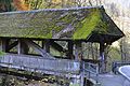
Deutsch: Pfaffenriedbrücke
covered wooden bridge over the Simme in Oberwil im Simmental in the canton of Bern, Switzerland  | |||||
| Upload media | |||||
| Instance of | |||||
|---|---|---|---|---|---|
| Part of | |||||
| Location | Oberwil im Simmental, Frutigen-Niedersimmental administrative district, Oberland administrative region, Bern, Switzerland | ||||
| Street address |
| ||||
| Crosses | |||||
| Heritage designation |
| ||||
| Inception |
| ||||
 | |||||
Media in category "Brücke (Pfaffenried 329, Oberwil im Simmental)"
The following 5 files are in this category, out of 5 total.
-
 CH-NB - Zweisimmen, Holzbrücke, vue d'ensemble - Collection Max van Berchem - EAD-6700.tif 5,148 × 3,719; 18.28 MB
-
 ETH-BIB-Simmenbrücke bei Pfaffenried, Détail-Dia 247-00510.tif 2,845 × 3,474; 9.53 MB
-
 ETH-BIB-Simmenbrücke bei Pfaffenried, Überblick-Dia 247-00511.tif 3,280 × 2,817; 8.9 MB
-
 Pfaffenriedbrücke über die Simme, Oberwil im Simmental BE 20220604-jag9889.jpg 4,608 × 3,456; 14.49 MB
-
 Обервиль - panoramio.jpg 4,288 × 2,848; 9.34 MB
