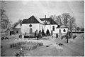
Category:Botilsäters kyrka
Jump to navigation
Jump to search
| Object location | | View all coordinates using: OpenStreetMap |
|---|
church building in Säffle Municipality, Sweden  | |||||
| Upload media | |||||
| Instance of | |||||
|---|---|---|---|---|---|
| Location | Säffle Municipality, Värmland County, Sweden | ||||
| Diocese | |||||
| Has use |
| ||||
| Occupant | |||||
| Heritage designation |
| ||||
 | |||||
|
This is a category about an ecclesiastical monument in Sweden, number 21300000004461 in the RAÄ buildings database.
|
|
This is a category about a protected building in Sweden, number 21400000440426 in the RAÄ buildings database.
|
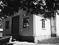
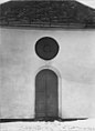
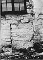
Media in category "Botilsäters kyrka"
The following 44 files are in this category, out of 44 total.
-
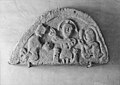
 Botilsäter-tympanonforshemsmästaren-SHM.png 1,464 × 787; 822 KB
-
 Botilsäters kyrka - KMB - 16000200144787.jpg 897 × 600; 113 KB
-
 Botilsäters kyrka - KMB - 16000200144788.jpg 897 × 600; 94 KB
-
 Botilsäters kyrka - KMB - 16000200144789.jpg 900 × 600; 137 KB
-
 Botilsäters kyrka - KMB - 16000200144790.jpg 898 × 600; 132 KB
-
 Botilsäters kyrka - KMB - 16000200144791.jpg 895 × 600; 123 KB
-
 Botilsäters kyrka - KMB - 16000200144792.jpg 801 × 600; 120 KB
-
 Botilsäters kyrka - KMB - 16000200144793.jpg 792 × 600; 71 KB
-
 Botilsäters kyrka - KMB - 16000200144794.jpg 436 × 600; 29 KB
-
 Botilsäters kyrka - KMB - 16000200144795.jpg 849 × 600; 84 KB
-
 Botilsäters kyrka - KMB - 16000200144796.jpg 440 × 600; 63 KB
-
 Botilsäters kyrka - KMB - 16000200144797.jpg 802 × 600; 79 KB
-
 Botilsäters kyrka - KMB - 16000200144798.jpg 433 × 600; 29 KB
-
 Botilsäters kyrka - KMB - 16000200144799.jpg 455 × 600; 56 KB
-
 Botilsäters kyrka - KMB - 16000200144800.jpg 855 × 600; 106 KB
-
 Botilsäters kyrka - KMB - 16000200144801.jpg 425 × 600; 71 KB
-
 Botilsäters kyrka - KMB - 16000200144802.jpg 1,400 × 594; 140 KB
-
 Botilsäters kyrka - KMB - 16000200144803.jpg 799 × 600; 102 KB
-
 Botilsäters kyrka - KMB - 16000200144804.jpg 904 × 600; 97 KB
-
 Botilsäters kyrka - KMB - 16000200144805.jpg 825 × 600; 140 KB
-
 Botilsäters kyrka - KMB - 16000200144806.jpg 841 × 600; 95 KB
-
 Botilsäters kyrka - KMB - 16000200144808.jpg 846 × 600; 119 KB
-
 Botilsäters kyrka - KMB - 16000200144809.jpg 938 × 600; 97 KB
-
 Botilsäters kyrka - KMB - 16000200144810.jpg 736 × 600; 80 KB
-
 Botilsäters kyrka - KMB - 16000200144811.jpg 825 × 600; 74 KB
-
 Botilsäters kyrka - KMB - 16000200144812.jpg 395 × 600; 54 KB
-
 Botilsäters kyrka - KMB - 16000200144813.jpg 376 × 600; 39 KB
-
 Botilsäters kyrka - KMB - 16000200144814.jpg 484 × 600; 59 KB
-
 Botilsäters kyrka - KMB - 16000200144815.jpg 421 × 600; 38 KB
-
 Botilsäters kyrka - KMB - 16000200144816.jpg 439 × 600; 62 KB
-
 Botilsäters kyrka - KMB - 16000200144817.jpg 819 × 600; 179 KB
-
 Botilsäters kyrka - KMB - 16000200144818.jpg 889 × 600; 181 KB
-
 Botilsäters kyrka - KMB - 16000200144819.jpg 877 × 600; 182 KB
-
 Botilsäters kyrka - KMB - 16000200144820.jpg 422 × 600; 45 KB
-
 Botilsäters kyrka - KMB - 16000200144825.jpg 395 × 600; 45 KB
-
 Botilsäters kyrka - KMB - 16000200144826.jpg 411 × 600; 20 KB
-
 Botilsäters kyrka - KMB - 16000200144827.jpg 429 × 600; 36 KB
-
 Botilsäters kyrka - KMB - 16000200144828.jpg 427 × 600; 35 KB
-
 Botilsäters kyrka - KMB - 16000200144829.jpg 431 × 600; 46 KB
-
 Botilsäters kyrka - KMB - 16000200144830.jpg 423 × 600; 31 KB
-
 Botilsäters kyrka - KMB - 16000200144831.jpg 432 × 600; 35 KB
-
 Botilsäters kyrka - KMB - 16000200144832.jpg 451 × 600; 19 KB
-
 Botilsäters kyrka - KMB - 16000200144833.jpg 472 × 600; 38 KB
-
 Botilsäters kyrka - KMB - 16000200144834.jpg 434 × 600; 55 KB


