Category:Bondkyrkan
Jump to navigation
Jump to search
|
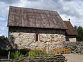
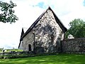
This is a category about a protected building in Sweden, number 21400000442910 in the RAÄ buildings database.
|
| Object location | | View all coordinates using: OpenStreetMap |
|---|
Media in category "Bondkyrkan"
The following 43 files are in this category, out of 43 total.
-
 Bondkyrkan - KMB - 16000200086824.jpg 608 × 600; 54 KB
-
 Bondkyrkan - KMB - 16000200086878.jpg 916 × 600; 114 KB
-
 Bondkyrkan - KMB - 16000200086879.jpg 909 × 600; 121 KB
-
 Nydala bondkyrkan Ext (1).JPG 2,592 × 1,944; 2.09 MB
-
 Nydala bondkyrkan Ext (2).JPG 2,592 × 1,944; 2.02 MB
-
 Nydala bondkyrkan Int.JPG 2,592 × 1,944; 2.22 MB
-
 Nydala klosterkyrkan Int (1).JPG 2,592 × 1,944; 2.14 MB
-
 Nydala kyrka (Nydala Klosterkyrka) (2).jpg 772 × 513; 77 KB
-
 Nydala, Bondkyrkan - KMB - 16000200086826.jpg 416 × 600; 25 KB
-
 Nydala, Bondkyrkan - KMB - 16000200086827.jpg 826 × 570; 48 KB
-
 Nydala, Bondkyrkan - KMB - 16000200086830.jpg 417 × 600; 22 KB
-
 Nydala, Bondkyrkan - KMB - 16000200086832.jpg 602 × 600; 19 KB
-
 Nydala, Bondkyrkan - KMB - 16000200086834.jpg 605 × 600; 32 KB
-
 Nydala, Bondkyrkan - KMB - 16000200086835.jpg 606 × 600; 30 KB
-
 Nydala, Bondkyrkan - KMB - 16000200086836.jpg 604 × 600; 40 KB
-
 Nydala, Bondkyrkan - KMB - 16000200086837.jpg 604 × 600; 33 KB
-
 Nydala, Bondkyrkan - KMB - 16000200086838.jpg 575 × 600; 53 KB
-
 Nydala, Bondkyrkan - KMB - 16000200086840.jpg 578 × 600; 58 KB
-
 Nydala, Bondkyrkan - KMB - 16000200086842.jpg 578 × 600; 51 KB
-
 Nydala, Bondkyrkan - KMB - 16000200086843.jpg 576 × 600; 54 KB
-
 Nydala, Bondkyrkan - KMB - 16000200086846.jpg 577 × 600; 40 KB
-
 Nydala, Bondkyrkan - KMB - 16000200086848.jpg 577 × 600; 35 KB
-
 Nydala, Bondkyrkan - KMB - 16000200086849.jpg 575 × 600; 29 KB
-
 Nydala, Bondkyrkan - KMB - 16000200086851.jpg 578 × 600; 43 KB
-
 Nydala, Bondkyrkan - KMB - 16000200086853.jpg 577 × 600; 37 KB
-
 Nydala, Bondkyrkan - KMB - 16000200086854.jpg 575 × 600; 42 KB
-
 Nydala, Bondkyrkan - KMB - 16000200086856.jpg 826 × 550; 48 KB
-
 Nydala, Bondkyrkan - KMB - 16000200086860.jpg 826 × 548; 53 KB
-
 Nydala, Bondkyrkan - KMB - 16000200086861.jpg 826 × 546; 49 KB
-
 Nydala, Bondkyrkan - KMB - 16000200086863.jpg 578 × 600; 36 KB
-
 Nydala, Bondkyrkan - KMB - 16000200086868.jpg 578 × 600; 36 KB
-
 Nydala, Bondkyrkan - KMB - 16000200086870.jpg 579 × 600; 44 KB
-
 Nydala, Bondkyrkan - KMB - 16000200086871.jpg 826 × 548; 70 KB
-
 Nydala, Bondkyrkan - KMB - 16000200086872.jpg 826 × 547; 68 KB
-
 Nydala, Bondkyrkan - KMB - 16000200086876.jpg 577 × 600; 41 KB
-
 Nydala, Bondkyrkan - KMB - 16000200086877.jpg 578 × 600; 36 KB
-
 Nydala, Bondkyrkan - KMB - 16000200086880.jpg 576 × 600; 40 KB
-
 Nydala, Bondkyrkan - KMB - 16000200086881.jpg 826 × 550; 60 KB
-
 Nydala, Bondkyrkan - KMB - 16000200086883.jpg 826 × 545; 65 KB
-
 Nydala, Bondkyrkan - KMB - 16000200086887.jpg 579 × 600; 43 KB
-
 Nydala, Bondkyrkan - KMB - 16000200086888.jpg 605 × 600; 15 KB
-
 Nydala, Bondkyrkan - KMB - 16000200086891.jpg 821 × 600; 25 KB
-
 Nydala, Bondkyrkan - KMB - 16000200086892.jpg 826 × 600; 29 KB


.JPG)
.JPG)

.JPG)
_(2).jpg)


Categories:
- Built in Värnamo Municipality in 1143
- Churches in the Diocese of Växjö
- Churches in Småland
- Churches in Värnamo Municipality
- Churches in Sweden built in 1143
- 12th-century churches in Jönköping County
- Gray churches in Sweden
- Fieldstone churches in Jönköping County
- Romanesque stone churches in Jönköping County
- Nydala kloster